
FCCInfo.com
A Service of Cavell, Mertz & Associates, Inc.
(855) FCC-INFO
|
|
|
|
|
||||||||||||||||
|
|
W300CI Channel: 300D 107.9 MHz Cincinnati, Ohio Service: FX - A translator or application for a translator. Facility ID: 156580 Fac. Service: FX Programming Delivery Method: Unspecified Status: License Application Accepted: 02/02/2018 Application Granted: 02/07/2018 File Number: BLFT-20180202AAV License Expires: 00/00/0000 Prefix Type: This is a license for a translator Application Type: License To Cover FCC Website Links: LMS Facility Details This Application CDBS Application Other W300CI Applications Other W300CI Applications in CDBS Including Superseded Applications Mailing Address Correspondence for W300CI Correspondence related to application BLFT-20180202AAV Service Contour - Open Street Map or USGS Map (60 dBu) Service Contour - KML / Google Earth (60 dBu) Class: D, A Noncommercial educational operating with no more than 10W Site Location: 39-02-36.2 N 84-28-53.8 W (NAD 83) Site Location: 39-02-36.0 N 84-28-54.0 W (Converted to NAD 27) Effective Radiated Power: 0.25 kW Transmitter Output Power: 0.706 kW Antenna Center HAAT: 0 m Antenna Center AMSL: 314 m (1030 ft.) Antenna Center HAG: 81 m (266 ft.) Site Elevation: 233 m. (764 ft.) Height Overall*: 87 m (285 ft.) (* As Filed In This Application, may differ from ASR Data, Below.) Directional Antenna Antenna Make/Model: None Antenna ID: 127944 Polarization:
| ||||||||||||||||||
| Antenna Data for Antenna Id: 127944 W300CI FX File: BLFT-20180202AAV None - Service: FX | 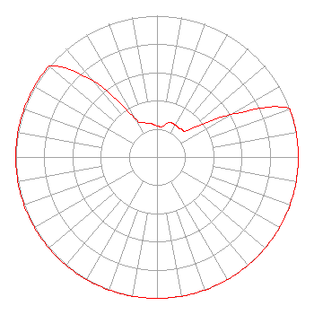 | ||||||||||||||||||
| Azimuth | Ratio | Azimuth | Ratio | Azimuth | Ratio | Azimuth | Ratio | ||||||||||||
| 0 | 0.220 | 10 | 0.220 | 20 | 0.260 | 30 | 0.260 | ||||||||||||
| 40 | 0.260 | 50 | 0.300 | 60 | 0.600 | 70 | 1.000 | ||||||||||||
| 80 | 1.000 | 90 | 1.000 | 100 | 1.000 | 110 | 1.000 | ||||||||||||
| 120 | 1.000 | 130 | 1.000 | 140 | 1.000 | 150 | 1.000 | ||||||||||||
| 160 | 1.000 | 170 | 1.000 | 180 | 1.000 | 190 | 1.000 | ||||||||||||
| 200 | 1.000 | 210 | 1.000 | 220 | 1.000 | 230 | 1.000 | ||||||||||||
| 240 | 1.000 | 250 | 1.000 | 260 | 1.000 | 270 | 1.000 | ||||||||||||
| 280 | 1.000 | 290 | 1.000 | 300 | 1.000 | 310 | 1.000 | ||||||||||||
| 320 | 0.700 | 330 | 0.320 | 340 | 0.260 | 350 | 0.240 | ||||||||||||
Structure Registration Number 1017797 [ASR Heights Differ from W300CI Application] Structure Type: TOWER Registered To: Cellco Partnership Structure Address: 1202 Johns Hills Road Cold Springs, KY County Name: Campbell County ASR Issued: 02/04/2019 Date Built: 09/08/2005 Site Elevation: 233.2 m (765 ft.) Structure Height: 85.3 m (280 ft.) Height Overall: 86.5 m (284 ft.) Overall Height AMSL: 319.7 m (1049 ft.) FAA Determination: 11/16/2004 FAA Study #: 2004-ASO-6288-OE FAA Circular #: 70/7460-1K Paint & Light FAA Chapters: 4, 8, 12 PRIOR STUDY 1985-ASO-2278-OE 39-02-36.2 N 84-28-53.8 W (NAD 83) 39-02-36.0 N 84-28-54.0 W (Converted to NAD 27) |
665 Homestead St. Lafayette, CO 80026 Phone: 303-664-1998 | Date: 02/02/2018 Application Certifier MARY MEDICUS 665 Homestead St. Lafayette, CO 80026 Applicant KEVIN J. YOUNGERS 3004 70th Ave Greeley, CO 80634 TECHNICAL CONSULTANT MARY MEDICUS Mary Medicus 655 Homestead Street Lafayette, CO 80026 | |||||||||||||||||