
FCCInfo.com
A Service of Cavell, Mertz & Associates, Inc.
(855) FCC-INFO
|
|
W240DJ from 11/05/2013 |
|
|
||||||||||||||||
|
|
W240DJ Channel: 240D 95.9 MHz Washington, District of Columbia Service: FX - A translator or application for a translator. Facility ID: 139772 Fac. Service: FX Programming Delivery Method: Unspecified Status: License Application Accepted: 09/20/2019 Application Granted: 09/30/2019 File Number: BLFT-20190920ABG License Expires: 00/00/0000 Prefix Type: This is a license for a translator Application Type: License To Cover FCC Website Links: LMS Facility Details This Application CDBS Application Other W240DJ Applications Other W240DJ Applications in CDBS Including Superseded Applications Mailing Address Correspondence for W240DJ Correspondence related to application BLFT-20190920ABG Service Contour - Open Street Map or USGS Map (60 dBu) Service Contour - KML / Google Earth (60 dBu) Class: D, A Noncommercial educational operating with no more than 10W Site Location: 39-00-00.4 N 77-03-24.9 W (NAD 83) Site Location: 39-00-00.0 N 77-03-26.0 W (Converted to NAD 27) Effective Radiated Power: 0.25 kW Transmitter Output Power: 0.512 kW Antenna Center HAAT: 0 m Antenna Center AMSL: 280 m (919 ft.) Antenna Center HAG: 190 m (623 ft.) Site Elevation: 90 m. (295 ft.) Height Overall*: 230 m (755 ft.) (* As Filed In This Application, may differ from ASR Data, Below.) Directional Antenna Antenna Make/Model: None Antenna ID: 135214 Polarization:
| ||||||||||||||||||
| Antenna Data for Antenna Id: 135214 W240DJ FX File: BLFT-20190920ABG None - Service: FX | 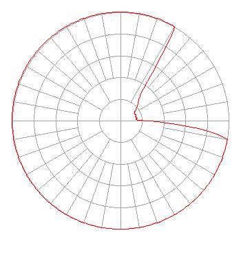 | ||||||||||||||||||
| Azimuth | Ratio | Azimuth | Ratio | Azimuth | Ratio | Azimuth | Ratio | ||||||||||||
| 0 | 1.000 | 10 | 1.000 | 20 | 1.000 | 30 | 1.000 | ||||||||||||
| 35 | 0.400 | 40 | 0.270 | 50 | 0.200 | 60 | 0.150 | ||||||||||||
| 70 | 0.150 | 80 | 0.150 | 90 | 0.230 | 100 | 1.000 | ||||||||||||
| 110 | 1.000 | 120 | 1.000 | 130 | 1.000 | 140 | 1.000 | ||||||||||||
| 150 | 1.000 | 160 | 1.000 | 170 | 1.000 | 180 | 1.000 | ||||||||||||
| 190 | 1.000 | 200 | 1.000 | 210 | 1.000 | 220 | 1.000 | ||||||||||||
| 230 | 1.000 | 240 | 1.000 | 250 | 1.000 | 260 | 1.000 | ||||||||||||
| 270 | 1.000 | 280 | 1.000 | 290 | 1.000 | 300 | 1.000 | ||||||||||||
| 310 | 1.000 | 320 | 1.000 | 330 | 1.000 | 340 | 1.000 | ||||||||||||
| 350 | 1.000 | ||||||||||||||||||
Structure Registration Number 1042694 Structure Type: 3TA1 Registered To: Vertical Bridge CC FM, LLC Structure Address: Twr 1 - Center - 8744 Brookville Rd Silver Spring, MD County Name: Montgomery County ASR Issued: 11/08/2018 Date Built: 07/01/1985 Site Elevation: 90.3 m (296 ft.) Structure Height: 211.8 m (695 ft.) Height Overall: 229.9 m (754 ft.) Overall Height AMSL: 320.2 m (1051 ft.) FAA Determination: 03/27/1998 FAA Study #: 98-AEA-0685-OE FAA Circular #: 70/7460-1J Paint & Light FAA Chapters: 4, 9, 13 39-00-00.0 N 77-03-25.0 W (NAD 83) 38-59-59.6 N 77-03-26.1 W (Converted to NAD 27) |
1010 Wayne Avenue 14th Floor Silver Spring, MD 20910 Phone: 301-429-3200 | Date: 09/20/2019 Application Certifier RADIO ONE LICENSES, LLC 1010 Wayne Avenue, 14th Floor Silver Spring, MD 20910 Applicant GREG STRICKLAND Urban One, Inc 1010 Wayne Avenue, 14th Floor Silver Spring, MD 20910 CORPORATE ENGINEER SONYA HALL-HARRIS Urban One, Inc. 1010 Wayne Avenue, 14th Floor Silver Spring, MD 20910 | |||||||||||||||||