
FCCInfo.com
A Service of Cavell, Mertz & Associates, Inc.
(855) FCC-INFO
|
|
|
|
|
||||||||||||||||
|
|
KLJH-FM2 Channel: 296D 107.1 MHz Bloomfield, New Mexico Service: FB - A booster station or application for a booster. Facility ID: 184454 Fac. Service: FB Programming Delivery Method: Unspecified Status: License Application Accepted: 09/16/2011 Application Granted: 09/22/2011 File Number: BLFTB-20110916ABU License Expires: 00/00/0000 Prefix Type: This is a license for a booster Application Type: License To Cover FCC Website Links: LMS Facility Details This Application CDBS Application Other KLJH-FM2 Applications Other KLJH-FM2 Applications in CDBS Including Superseded Applications Mailing Address Correspondence for KLJH-FM2 Correspondence related to application BLFTB-20110916ABU Service Contour - Open Street Map or USGS Map (60 dBu) Service Contour - KML / Google Earth (60 dBu) Facility Type: FM STATION Class: D, A Noncommercial educational operating with no more than 10W Site Location: 36-48-53.0 N 107-53-33.2 W (NAD 83) Site Location: 36-48-53.0 N 107-53-31.0 W (Converted to NAD 27) Effective Radiated Power: 2.5 kW Horiz. ; 0 kW Vert. Transmitter Output Power: 0.71 kW Antenna Center HAAT: 0 m Antenna Center AMSL: 2133 m Horiz.; 0 m Vert. Antenna Center HAG: 64 m Horiz.; 0 m Vert. Site Elevation: 2069 m. (6788 ft.) Height Overall*: 92 m (302 ft.) (* As Filed In This Application, may differ from ASR Data, Below.) Directional Antenna Antenna Make/Model: None Antenna ID: 16150 Polarization:
| ||||||||||||||||||
| Antenna Data for Antenna Id: 16150 KLJH-FM2 FB File: BLFTB-20110916ABU None - Service: FB Pattern and Field Values Include a 250° Clockwise Rotation | 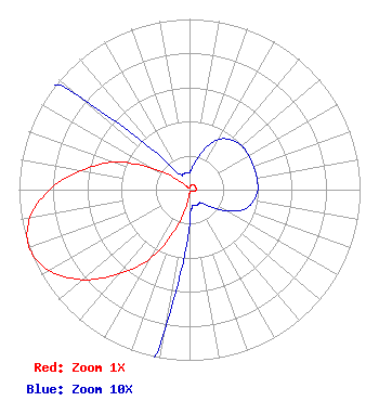 | ||||||||||||||||||
| Azimuth | Ratio | Azimuth | Ratio | Azimuth | Ratio | Azimuth | Ratio | ||||||||||||
| 0 | 0.010 | 10 | 0.015 | 20 | 0.025 | 30 | 0.034 | ||||||||||||
| 40 | 0.038 | 50 | 0.040 | 60 | 0.040 | 70 | 0.040 | ||||||||||||
| 80 | 0.040 | 90 | 0.040 | 100 | 0.038 | 110 | 0.034 | ||||||||||||
| 120 | 0.025 | 130 | 0.015 | 140 | 0.010 | 150 | 0.010 | ||||||||||||
| 160 | 0.010 | 170 | 0.010 | 180 | 0.020 | 190 | 0.085 | ||||||||||||
| 200 | 0.250 | 210 | 0.470 | 220 | 0.645 | 230 | 0.820 | ||||||||||||
| 240 | 0.950 | 250 | 1.000 | 260 | 0.950 | 270 | 0.820 | ||||||||||||
| 280 | 0.645 | 290 | 0.470 | 300 | 0.250 | 310 | 0.085 | ||||||||||||
| 320 | 0.020 | 330 | 0.010 | 340 | 0.010 | 350 | 0.010 | ||||||||||||
Structure Registration Number 1262083 Structure Type: TOWER Registered To: Voice Ministries of Farmington, Inc. Structure Address: Atop Knickerbocker Peak, 5.6 Miles East Of Aztec, Nm Aztec, NM County Name: San Juan County ASR Issued: 09/15/2010 Date Built: 09/13/2010 Site Elevation: 2069 m (6788 ft.) Structure Height: 91.5 m (300 ft.) Height Overall: 92.4 m (303 ft.) Overall Height AMSL: 2161.4 m (7091 ft.) FAA Determination: 06/15/2010 FAA Study #: 2010-ASW-2950-OE FAA Circular #: 70/7460-1K Paint & Light FAA Chapters: 4, 8, 12 PRIOR STUDY 2007-ASW-7313-OE 36-48-52.9 N 107-53-33.3 W (NAD 83) 36-48-52.9 N 107-53-31.1 W (Converted to NAD 27) |
1105 West Apache Street Farmington, NM 87401 Phone: 505-327-7202 Not-for-Profit | Date: 09/16/2011 Application Certifier VOICE MINISTRIES OF FARMINGTON, INC. P.o. Box 232 Farmington, NM 87499 Applicant GEORGE S. CRISSEY Bromo Communications, Inc. 218 Tiger Connector Tiger, GA 30576-2303 TECHNICAL CONSULTANT JEFFREY D. SOUTHMAYD Southmayd & Miller 4 Ocean Ridge Boulevard South Palm Coast, FL 32137 | |||||||||||||||||