
FCCInfo.com
A Service of Cavell, Mertz & Associates, Inc.
(855) FCC-INFO
|
|
|
|
|
||||||||||||||||
|
|
WKNS Channel: 212C2 90.3 MHz Kinston, North Carolina Service: FM - A full-service FM station or application. Facility ID: 14358 Fac. Service: FM Status: License Application Accepted: 06/04/1998 Application Granted: 12/10/2001 File Number: BLED-19980604KD License Expires: 00/00/0000 Prefix Type: This is a license for a noncommercial educational FM station Application Type: License To Cover FCC Website Links: LMS Facility Details This Application CDBS Application Other WKNS Applications Other WKNS Applications in CDBS Including Superseded Applications Mailing Address Correspondence for WKNS Correspondence related to application BLED-19980604KD Service Contour - Open Street Map or USGS Map (60 dBu) Service Contour - KML / Google Earth (60 dBu) Public Inspection Files History Cards for WKNS Facility Type: NON-COMMERCIAL EDUC. FM Class: C2, A Zone II station; with 25kW-50kW ERP and a class contour distance 39km-52km Site Location: 35-25-01.6 N 77-48-55.9 W (NAD 83) Site Location: 35-25-01.0 N 77-48-57.0 W (Converted to NAD 27) Effective Radiated Power: 35 kW Horiz. ; 34 kW Vert. Transmitter Output Power: 7.9 kW Antenna Center HAAT: 98 m (322 ft.) Antenna Center AMSL: 130 m (427 ft.) Antenna Center HAG: 94 m (308 ft.) Site Elevation: 36 m. (118 ft.) Height Overall*: 105 m (344 ft.) (* As Filed In This Application, may differ from ASR Data, Below.) Directional Antenna Antenna Make/Model: None Jampro JBCP-4H DA, 4 section Antenna ID: 15193 Polarization:
| ||||||||||||||||||
| Antenna Data for Antenna Id: 15193 WKNS FM File: BLED-19980604KD None - Jampro JBCP-4H DA, 4 section Service: FM | 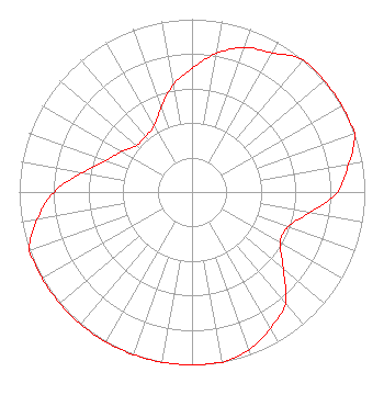 | ||||||||||||||||||
| Azimuth | Ratio | Azimuth | Ratio | Azimuth | Ratio | Azimuth | Ratio | ||||||||||||
| 0 | 0.715 | 10 | 0.815 | 20 | 0.890 | 30 | 0.930 | ||||||||||||
| 40 | 1.000 | 50 | 1.000 | 60 | 1.000 | 70 | 1.000 | ||||||||||||
| 80 | 0.920 | 90 | 0.840 | 100 | 0.690 | 110 | 0.590 | ||||||||||||
| 120 | 0.590 | 130 | 0.690 | 140 | 0.840 | 150 | 0.910 | ||||||||||||
| 160 | 0.970 | 170 | 1.000 | 180 | 1.000 | 190 | 1.000 | ||||||||||||
| 200 | 1.000 | 210 | 1.000 | 220 | 1.000 | 230 | 1.000 | ||||||||||||
| 240 | 1.000 | 250 | 1.000 | 260 | 0.910 | 270 | 0.800 | ||||||||||||
| 280 | 0.645 | 290 | 0.530 | 300 | 0.470 | 310 | 0.420 | ||||||||||||
| 320 | 0.420 | 330 | 0.440 | 340 | 0.520 | 350 | 0.630 | ||||||||||||
Structure Registration Number 1027311 Structure Type: TOWER Registered To: BOARD OF TRUSTEES CRAVEN COMMUNITY COLLEGE Structure Address: Sr 1140 .9 Km Sw Of Sr 1137 Oakdale, NC County Name: Greene County ASR Issued: 08/11/1997 Date Built: 01/25/1997 Site Elevation: 36 m (118 ft.) Structure Height: 104.6 m (343 ft.) Height Overall: 104.6 m (343 ft.) Overall Height AMSL: 140.6 m (461 ft.) FAA Determination: 06/11/1996 FAA Study #: 96-ASO-1794-OE FAA Circular #: 70/7460-1J Paint & Light FAA Chapters: 3, 4, 5, 13 RED LIGHTS/PAINT 35-25-02.0 N 77-48-56.0 W (NAD 83) 35-25-01.4 N 77-48-57.1 W (Converted to NAD 27) |
800 College Court New Bern, NC 28562 | Date: 06/04/1998 Application Certifier CRAVEN COMMUNITY COLLEGE Craven Community College 800 College Ct New Bern, NC 28562 Applicant | |||||||||||||||||