
FCCInfo.com
A Service of Cavell, Mertz & Associates, Inc.
(855) FCC-INFO
|
|
|
|
|
||||||||||||||||
|
|
W236CI Channel: 236D 95.1 MHz Murfreesboro, Tennessee Service: FX - A translator or application for a translator. Facility ID: 141270 Fac. Service: FX Programming Delivery Method: Unspecified Status: License Application Accepted: 11/07/2014 Application Granted: 12/01/2014 File Number: BLFT-20141107AED License Expires: 00/00/0000 Prefix Type: This is a license for a translator Application Type: License To Cover FCC Website Links: LMS Facility Details This Application CDBS Application Other W236CI Applications Other W236CI Applications in CDBS Including Superseded Applications Mailing Address Correspondence for W236CI Correspondence related to application BLFT-20141107AED Service Contour - Open Street Map or USGS Map (60 dBu) Service Contour - KML / Google Earth (60 dBu) Class: D, A Noncommercial educational operating with no more than 10W Site Location: 35-50-56.2 N 86-21-11.0 W (NAD 83) Site Location: 35-50-56.0 N 86-21-11.0 W (Converted to NAD 27) Effective Radiated Power: 0.25 kW Transmitter Output Power: 0.224 kW Antenna Center HAAT: 0 m Antenna Center AMSL: 275 m (902 ft.) Antenna Center HAG: 83 m (272 ft.) Site Elevation: 192 m. (630 ft.) Height Overall*: 88 m (289 ft.) (* As Filed In This Application, may differ from ASR Data, Below.) Directional Antenna Antenna Make/Model: None Antenna ID: 119357 Polarization:
| ||||||||||||||||||
| Antenna Data for Antenna Id: 119357 W236CI FX File: BLFT-20141107AED None - Service: FX | 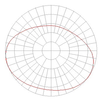 | ||||||||||||||||||
| Azimuth | Ratio | Azimuth | Ratio | Azimuth | Ratio | Azimuth | Ratio | ||||||||||||
| 0 | 0.548 | 10 | 0.547 | 20 | 0.550 | 30 | 0.558 | ||||||||||||
| 40 | 0.575 | 50 | 0.608 | 60 | 0.651 | 70 | 0.707 | ||||||||||||
| 80 | 0.781 | 90 | 0.862 | 100 | 0.931 | 110 | 0.974 | ||||||||||||
| 120 | 0.994 | 130 | 0.993 | 140 | 0.974 | 150 | 0.945 | ||||||||||||
| 160 | 0.913 | 170 | 0.885 | 180 | 0.867 | 190 | 0.861 | ||||||||||||
| 200 | 0.868 | 210 | 0.888 | 220 | 0.916 | 230 | 0.948 | ||||||||||||
| 240 | 0.978 | 250 | 0.997 | 260 | 0.999 | 270 | 0.977 | ||||||||||||
| 280 | 0.933 | 290 | 0.864 | 300 | 0.780 | 310 | 0.705 | ||||||||||||
| 320 | 0.649 | 330 | 0.604 | 340 | 0.572 | 350 | 0.555 | ||||||||||||
Structure Registration Number 1061283 [ASR Heights Differ from W236CI Application] Structure Type: TOWER Registered To: MIDDLE TENNESSEE STATE UNIVERSITY DBA = (C/O RADIO STATION WMTS) Structure Address: N. Rutherford Blvd. (at Mtsu 2nd St. Intersection) Murfreesboro, TN County Name: Rutherford County ASR Issued: 03/04/1999 Date Built: 12/01/1971 Site Elevation: 192 m (630 ft.) Structure Height: 87.2 m (286 ft.) Height Overall: 87.5 m (287 ft.) Overall Height AMSL: 279.5 m (917 ft.) FAA Determination: 09/28/1993 FAA Study #: 93-ASO-1751-OE FAA Circular #: 70/7460-1H Paint & Light FAA Chapters: 3, 4, 5, 13 RED LIGHTS/PAINT 35-50-56.0 N 86-21-11.0 W (NAD 83) 35-50-55.8 N 86-21-11.0 W (Converted to NAD 27) |
P.o. Box 150846 Nashville, TN 37215 Phone: 615-361-7560 Corporation | Date: 11/07/2014 Application Certifier WYCQ, INC. P.o. Box 150846 Nashville, TN 37215 Applicant CHARLES M. ANDERSON Anderson Associates 1519 Euclid Avenue Bowling Green, KY 42103 CONSULTANT JOHN GARZIGLIA Womble Carlyle Sandridge & Rice, Llp 1200 19th Street, N.w., Suite 500 Washington, DC 20036 | |||||||||||||||||