
FCCInfo.com
A Service of Cavell, Mertz & Associates, Inc.
(855) FCC-INFO
|
|
|
|  |
|
|||||||||||||||
|
|
WBGO Channel: 202B1 88.3 MHz Newark, New Jersey Service: FM - A full-service FM station or application. Facility ID: 48699 Fac. Service: FM Analog & Digital Status: License Application Accepted: 12/13/2011 Application Granted: 12/20/2011 File Number: BLED-20111213ABV License Expires: 00/00/0000 Prefix Type: This is a license for a noncommercial educational FM station Application Type: License To Cover FCC Website Links: LMS Facility Details This Application CDBS Application Other WBGO Applications Other WBGO Applications in CDBS Including Superseded Applications Mailing Address Correspondence for WBGO Correspondence related to application BLED-20111213ABV Service Contour - Open Street Map or USGS Map (60 dBu) Service Contour - KML / Google Earth (60 dBu) Public Inspection Files History Cards for WBGO Facility Type: NON-COMMERCIAL EDUC. FM Class: B1, A Zone I or I-A station; with 6kW-25kW ERP and a class contour distance 28km-39km Site Location: 40-45-22.4 N 73-59-10.5 W (NAD 83) Site Location: 40-45-22.0 N 73-59-12.0 W (Converted to NAD 27) Effective Radiated Power: 2.5 kW Transmitter Output Power: 3.17 kW Antenna Center HAAT: 269.2 m (883 ft.) Antenna Center AMSL: 284 m (932 ft.) Antenna Center HAG: 269 m (883 ft.) Calculated Site Elevation: 15 m. (49 ft.) Height Overall*: 340.8 m (1118 ft.) (* As Filed In This Application, may differ from ASR Data, Below.) Directional Antenna Antenna Make/Model: Electronics Research Inc. 1182-1CP-DA-1 Antenna ID: 104256 Polarization: | ||||||||||||||||||
| Antenna Data for Antenna Id: 104256 WBGO FM File: BLED-20111213ABV Electronics Research Inc. - 1182-1CP-DA-1 Service: FM | 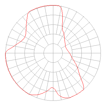 | ||||||||||||||||||
| Azimuth | Ratio | Azimuth | Ratio | Azimuth | Ratio | Azimuth | Ratio | ||||||||||||
| 0 | 1.000 | 10 | 0.959 | 20 | 0.573 | 30 | 0.459 | ||||||||||||
| 40 | 0.374 | 50 | 0.330 | 60 | 0.298 | 70 | 0.294 | ||||||||||||
| 80 | 0.310 | 90 | 0.345 | 100 | 0.387 | 110 | 0.464 | ||||||||||||
| 120 | 0.584 | 130 | 0.735 | 140 | 1.000 | 150 | 1.000 | ||||||||||||
| 160 | 1.000 | 170 | 0.925 | 180 | 0.731 | 190 | 0.821 | ||||||||||||
| 200 | 0.931 | 210 | 1.000 | 220 | 1.000 | 230 | 1.000 | ||||||||||||
| 240 | 1.000 | 250 | 1.000 | 260 | 1.000 | 270 | 1.000 | ||||||||||||
| 280 | 0.830 | 290 | 0.713 | 300 | 0.677 | 310 | 0.737 | ||||||||||||
| 320 | 0.860 | 330 | 1.000 | 340 | 1.000 | 350 | 1.000 | ||||||||||||
Structure Registration Number 1238745 [ASR Heights Differ from WBGO Application] Structure Type: BTWR Registered To: 4 TS II LLC Structure Address: 4 Times Square New York, NY County Name: New York County ASR Issued: 03/24/2014 Date Built: 10/01/2014 Site Elevation: 15.2 m (50 ft.) Structure Height: 328.2 m (1077 ft.) Height Overall: 349.7 m (1147 ft.) Overall Height AMSL: 364.9 m (1197 ft.) FAA Determination: 09/09/2013 FAA Study #: 2013-AEA-3207-OE FAA Circular #: 70/7460-1K Paint & Light FAA Chapters: 4, 5, 12 Removed expiration and final dates from determination. Scenario 2./jjs/case#635066 40-45-22.4 N 73-59-10.5 W (NAD 83) 40-45-22.0 N 73-59-12.0 W (Converted to NAD 27) |
54 Park Place Newark, NJ 07102 Phone: 973-624-8880 Fax: 973-824-8888 Not-for-Profit | Date: 12/13/2011 Application Certifier NEWARK PUBLIC RADIO INC. 54 Park Place Newark, NJ 07102 Applicant DOUG VERNIER Telecommunications Consultants 401 Main St, Suite 213 Cedar Falls, IA 50613 ENGINEERING CONSULTANT MARGARET L. MILLER Dow Lohnes Pllc | |||||||||||||||||