
FCCInfo.com
A Service of Cavell, Mertz & Associates, Inc.
(855) FCC-INFO
|
|
|
|
|
||||||||||||||||
|
|
K220EU Channel: 220D 91.9 MHz Erwinville, Louisiana Service: FX - A translator or application for a translator. Facility ID: 21099 Fac. Service: FX Programming Delivery Method: Unspecified Status: License Application Accepted: 09/17/2009 Application Granted: 09/28/2009 File Number: BLFT-20090917ABV License Expires: 00/00/0000 Prefix Type: This is a license for a translator Application Type: License To Cover FCC Website Links: LMS Facility Details This Application CDBS Application Other K220EU Applications Other K220EU Applications in CDBS Including Superseded Applications Mailing Address Correspondence for K220EU Correspondence related to application BLFT-20090917ABV Service Contour - Open Street Map or USGS Map (60 dBu) Service Contour - KML / Google Earth (60 dBu) Class: D, A Noncommercial educational operating with no more than 10W Site Location: 30-36-59.7 N 91-20-28.4 W (NAD 83) Site Location: 30-36-59.0 N 91-20-28.0 W (Converted to NAD 27) Effective Radiated Power: 0 kW Horiz. ; 0.15 kW Vert. Transmitter Output Power: 0.202 kW Antenna Center HAAT: 0 m Horiz.; 81.6 m Vert. Antenna Center AMSL: 0 m Horiz.; 91 m Vert. Antenna Center HAG: 0 m Horiz.; 82 m Vert. Site Elevation: 9 m. (30 ft.) Height Overall*: 104 m (341 ft.) (* As Filed In This Application, may differ from ASR Data, Below.) Directional Antenna Antenna Make/Model: None Antenna ID: 31326 Polarization:
| ||||||||||||||||||
| Antenna Data for Antenna Id: 31326 K220EU FX File: BLFT-20090917ABV None - Service: FX Pattern and Field Values Include a 225° Clockwise Rotation | 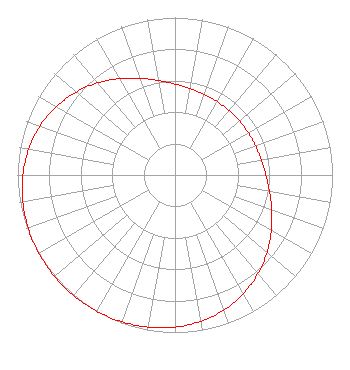 | ||||||||||||||||||
| Azimuth | Ratio | Azimuth | Ratio | Azimuth | Ratio | Azimuth | Ratio | ||||||||||||
| 5 | 0.566 | 15 | 0.549 | 25 | 0.540 | 35 | 0.535 | ||||||||||||
| 45 | 0.534 | 55 | 0.535 | 65 | 0.540 | 75 | 0.549 | ||||||||||||
| 85 | 0.566 | 95 | 0.592 | 105 | 0.630 | 115 | 0.679 | ||||||||||||
| 125 | 0.735 | 135 | 0.792 | 145 | 0.845 | 155 | 0.892 | ||||||||||||
| 165 | 0.929 | 175 | 0.956 | 185 | 0.975 | 195 | 0.987 | ||||||||||||
| 205 | 0.995 | 215 | 0.999 | 225 | 1.000 | 235 | 0.999 | ||||||||||||
| 245 | 0.995 | 255 | 0.987 | 265 | 0.975 | 275 | 0.956 | ||||||||||||
| 285 | 0.929 | 295 | 0.892 | 305 | 0.845 | 315 | 0.792 | ||||||||||||
| 325 | 0.735 | 335 | 0.679 | 345 | 0.630 | 355 | 0.592 | ||||||||||||
Structure Registration Number 1225274 Structure Type: GTOWER Registered To: American Towers LLC Structure Address: 5060 Arbroth Rd. (35756) Glynn, LA County Name: Pointe Coupee Parish ASR Issued: 02/12/2024 Date Built: 06/15/2001 Site Elevation: 9.1 m (30 ft.) Structure Height: 100.6 m (330 ft.) Height Overall: 104.2 m (342 ft.) Overall Height AMSL: 113.3 m (372 ft.) FAA Determination: 04/21/2023 FAA Study #: 2022-ASW-25123-OE FAA Circular #: 70/7460-1K Paint & Light FAA Chapters: 4, 8, 12 PRIOR STUDY 2004-ASW-3736-OE 30-36-59.9 N 91-20-27.9 W (NAD 83) 30-36-59.2 N 91-20-27.5 W (Converted to NAD 27) |
P.o. Box 391 4002 N. 3300 E. Twin Falls, ID 83303 Phone: 208-733-3133 | Date: 09/17/2009 Application Certifier CALVARY CHAPEL OF TWIN FALLS, INC. P.o. Box 391 Twin Falls, ID 83303 Applicant LOIS MILLS Po Box 391 Twin Falls, ID 83303 APPLICATIONS TECHNICIAN CARY S. TEPPER, ESQ. Booth, Freret, Imlay & Tepper, Pc 7900 Wisconsin Avenue Suite 304 Bethesda, MD 20814-3628 | |||||||||||||||||