
FCCInfo.com
A Service of Cavell, Mertz & Associates, Inc.
(855) FCC-INFO
|
|
W278BM from 06/08/2012 W278BM from 08/18/2004 |
|
|
||||||||||||||||
|
|
W278BM Channel: 278D 103.5 MHz Winston-salem, North Carolina Service: FX - A translator or application for a translator. Facility ID: 139568 Fac. Service: FX Programming Delivery Method: Unspecified Status: License Application Accepted: 08/01/2018 Application Granted: 08/15/2018 File Number: BLFT-20180801AAR License Expires: 00/00/0000 Prefix Type: This is a license for a translator Application Type: License To Cover FCC Website Links: LMS Facility Details This Application CDBS Application Other W278BM Applications Other W278BM Applications in CDBS Including Superseded Applications Mailing Address Correspondence for W278BM Correspondence related to application BLFT-20180801AAR Service Contour - Open Street Map or USGS Map (60 dBu) Service Contour - KML / Google Earth (60 dBu) Class: D, A Noncommercial educational operating with no more than 10W Site Location: 36-04-26.5 N 80-15-17.2 W (NAD 83) Site Location: 36-04-26.0 N 80-15-18.0 W (Converted to NAD 27) Effective Radiated Power: 0.25 kW Transmitter Output Power: 0.825 kW Antenna Center HAAT: 0 m Antenna Center AMSL: 321 m (1053 ft.) Antenna Center HAG: 102 m (335 ft.) Site Elevation: 219 m. (719 ft.) Height Overall*: 117 m (384 ft.) (* As Filed In This Application, may differ from ASR Data, Below.) Directional Antenna Antenna Make/Model: None Antenna ID: 132555 Polarization:
| ||||||||||||||||||
| Antenna Data for Antenna Id: 132555 W278BM FX File: BLFT-20180801AAR None - Service: FX | 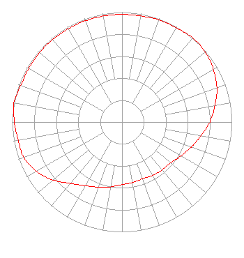 | ||||||||||||||||||
| Azimuth | Ratio | Azimuth | Ratio | Azimuth | Ratio | Azimuth | Ratio | ||||||||||||
| 0 | 0.980 | 10 | 0.980 | 20 | 0.990 | 30 | 0.990 | ||||||||||||
| 40 | 1.000 | 50 | 0.990 | 60 | 0.960 | 70 | 0.920 | ||||||||||||
| 80 | 0.860 | 90 | 0.800 | 100 | 0.730 | 110 | 0.670 | ||||||||||||
| 120 | 0.620 | 130 | 0.580 | 140 | 0.570 | 150 | 0.560 | ||||||||||||
| 160 | 0.550 | 170 | 0.560 | 180 | 0.570 | 190 | 0.600 | ||||||||||||
| 200 | 0.630 | 210 | 0.670 | 220 | 0.730 | 230 | 0.820 | ||||||||||||
| 240 | 0.900 | 250 | 0.950 | 260 | 0.960 | 270 | 0.980 | ||||||||||||
| 280 | 1.000 | 290 | 0.980 | 300 | 0.980 | 310 | 0.980 | ||||||||||||
| 320 | 0.980 | 330 | 0.980 | 340 | 0.980 | 350 | 0.980 | ||||||||||||
Structure Registration Number 1230607 Structure Type: TOWER Registered To: Truth Broadcasting Corporation Structure Address: N 36-04-26.0 W 080-15-17.0 Winston Salem, NC County Name: Forsyth County ASR Issued: 05/16/2023 Date Built: 02/01/1937 Site Elevation: 218.6 m (717 ft.) Structure Height: 117.3 m (385 ft.) Height Overall: 117.3 m (385 ft.) Overall Height AMSL: 335.9 m (1102 ft.) FAA Determination: 10/26/2001 FAA Study #: 01-ASO-8305-OE Paint & Light FAA Chapters: 1, 3, 12, 21 OM&L TO REMAIN PAINT RED LIGHTS AS PER PRIOR STUDY SO-OE-3307-OE 36-04-26.0 N 80-15-17.0 W (NAD 83) 36-04-25.5 N 80-15-17.8 W (Converted to NAD 27) |
4405 Providence Lane Suite D Winston-salem, NC 27106 Phone: 336-759-0363 Corporation | Date: 08/01/2018 Application Certifier TRUTH BROADCASTING CORPORATION 4405 Providence Lane Suite D Winston-salem, NC 27106 Applicant CARL E GLUCK Carl T Jones Corp 7901 Yarnwood Court Springfield, VA 22153-2899 TECHNICAL CONSULTANT DAVINA SASHKIN, ESQ. Fletcher, Heald & Hildreth, Plc 1300 North 17th Street 11th Floor Arlington, VA 22209 | |||||||||||||||||