
FCCInfo.com
A Service of Cavell, Mertz & Associates, Inc.
(855) FCC-INFO
|
|
|
|  |
|
|||||||||||||||
|
|
WATP Channel: 215C1 90.9 MHz Laurel, Mississippi Service: FM - A full-service FM station or application. Facility ID: 82443 Fac. Service: FM Status: License Application Accepted: 07/03/2007 Application Granted: 07/20/2007 File Number: BLED-20070703AAX License Expires: 00/00/0000 Prefix Type: This is a license for a noncommercial educational FM station Application Type: License To Cover FCC Website Links: LMS Facility Details This Application CDBS Application Other WATP Applications Other WATP Applications in CDBS Including Superseded Applications Mailing Address Correspondence for WATP Correspondence related to application BLED-20070703AAX Service Contour - Open Street Map or USGS Map (60 dBu) Service Contour - KML / Google Earth (60 dBu) Public Inspection Files Facility Type: NON-COMMERCIAL EDUC. FM Class: C1, A Zone II station; with 50kW-100kW ERP and a class contour distance 52km-72km Site Location: 31-52-39.6 N 88-52-44.2 W (NAD 83) Site Location: 31-52-39.0 N 88-52-44.0 W (Converted to NAD 27) Effective Radiated Power: 69 kW Transmitter Output Power: 10.4 kW Antenna Center HAAT: 220.5 m (723 ft.) Antenna Center AMSL: 313 m (1027 ft.) Antenna Center HAG: 160 m (525 ft.) Site Elevation: 153 m. (502 ft.) Height Overall*: 177 m (581 ft.) (* As Filed In This Application, may differ from ASR Data, Below.) Directional Antenna Antenna Make/Model: Shivley 6810-8-D4, eight sections Antenna ID: 76839 Polarization:
| ||||||||||||||||||
| Antenna Data for Antenna Id: 76839 WATP FM File: BLED-20070703AAX Shivley - 6810-8-D4, eight sections Service: FM | 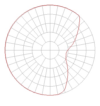 | ||||||||||||||||||
| Azimuth | Ratio | Azimuth | Ratio | Azimuth | Ratio | Azimuth | Ratio | ||||||||||||
| 0 | 1.000 | 10 | 1.000 | 20 | 1.000 | 30 | 1.000 | ||||||||||||
| 40 | 1.000 | 50 | 0.842 | 60 | 0.692 | 70 | 0.581 | ||||||||||||
| 80 | 0.475 | 90 | 0.395 | 100 | 0.366 | 110 | 0.378 | ||||||||||||
| 120 | 0.406 | 130 | 0.496 | 140 | 0.618 | 150 | 0.762 | ||||||||||||
| 160 | 0.935 | 170 | 1.000 | 180 | 1.000 | 190 | 1.000 | ||||||||||||
| 200 | 1.000 | 210 | 1.000 | 220 | 1.000 | 230 | 1.000 | ||||||||||||
| 240 | 1.000 | 250 | 1.000 | 260 | 1.000 | 270 | 1.000 | ||||||||||||
| 280 | 1.000 | 290 | 1.000 | 300 | 1.000 | 310 | 1.000 | ||||||||||||
| 320 | 1.000 | 330 | 1.000 | 340 | 1.000 | 350 | 1.000 | ||||||||||||
Structure Registration Number 1256379 Structure Type: TOWER Registered To: AMERICAN FAMILY ASSOCIATION Structure Address: 3017 Cr 240 Heidelberg, MS County Name: Clarke County ASR Issued: 10/19/2009 Date Built: 06/07/2007 Site Elevation: 153 m (502 ft.) Structure Height: 177 m (581 ft.) Height Overall: 177 m (581 ft.) Overall Height AMSL: 330 m (1083 ft.) FAA Determination: 10/18/2006 FAA Study #: 2006-ASO-5705-OE Paint & Light FAA Chapters: B, C, H, 3, 4, 13, 21, 23 Continue As Is OM&L = A HIGH-DUAL SYSTEM 31-52-39.2 N 88-52-43.7 W (NAD 83) 31-52-38.6 N 88-52-43.5 W (Converted to NAD 27) |
P.o. Drawer 2440 Tupelo, MS 38801 Phone: 662-844-8888 Not-for-Profit | Date: 07/03/2007 Application Certifier AMERICAN FAMILY ASSOCIATION P.o. Drawer 2440 Tupelo, MS 38801 Applicant JESSICA HUCKABY P.o. Drawer 2440 Tupelo, MS 38803 TECHNICAL CONSULTANT JESSICA HUCKABY American Family Association | |||||||||||||||||