
FCCInfo.com
A Service of Cavell, Mertz & Associates, Inc.
(855) FCC-INFO
|
|
|
|
|
|||||||||||||||||||
|
|
WHSA Channel: 210C1 89.9 MHz Brule, Wisconsin Service: FM - A full-service FM station or application. Facility ID: 63089 Fac. Service: FM Analog & Digital Status: License Application Accepted: 09/20/2012 Application Granted: 10/02/2012 File Number: BLED-20120920ADG License Expires: 00/00/0000 Prefix Type: This is a license for a noncommercial educational FM station Application Type: License To Cover FCC Website Links: LMS Facility Details This Application CDBS Application Other WHSA Applications Other WHSA Applications in CDBS Including Superseded Applications Mailing Address Correspondence for WHSA Correspondence related to application BLED-20120920ADG Service Contour - Open Street Map or USGS Map (60 dBu) Service Contour - KML / Google Earth (60 dBu) Public Inspection Files History Cards for WHSA Facility Type: NON-COMMERCIAL EDUC. FM Class: C1, A Zone II station; with 50kW-100kW ERP and a class contour distance 52km-72km Site Location: 46-27-59.9 N 91-33-59.5 W (NAD 83) Site Location: 46-28-00.1 N 91-33-58.8 W (Converted to NAD 27) Effective Radiated Power: 92 kW Transmitter Output Power: 13.43 kW Antenna Center HAAT: 157 m (515 ft.) Antenna Center AMSL: 519.2 m (1703 ft.) Antenna Center HAG: 108.2 m (355 ft.) Calculated Site Elevation: 411 m. (1348 ft.) Height Overall*: 122.5 m (402 ft.) (* As Filed In This Application, may differ from ASR Data, Below.) Directional Antenna Antenna Make/Model: DIELECTRIC DCR, eight sections Antenna ID: 110149 Polarization: | |||||||||||||||||||||
| Antenna Data for Antenna Id: 110149 WHSA FM File: BLED-20120920ADG DIELECTRIC - DCR, eight sections Service: FM | 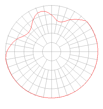 | |||||||||||||||||||||
| Azimuth | Ratio | Azimuth | Ratio | Azimuth | Ratio | Azimuth | Ratio | |||||||||||||||
| 0 | 0.790 | 10 | 0.680 | 20 | 0.680 | 30 | 0.790 | |||||||||||||||
| 40 | 0.900 | 50 | 1.000 | 60 | 1.000 | 70 | 1.000 | |||||||||||||||
| 80 | 1.000 | 90 | 1.000 | 100 | 1.000 | 110 | 1.000 | |||||||||||||||
| 120 | 1.000 | 130 | 1.000 | 140 | 1.000 | 150 | 1.000 | |||||||||||||||
| 160 | 1.000 | 170 | 1.000 | 180 | 1.000 | 190 | 1.000 | |||||||||||||||
| 200 | 1.000 | 210 | 1.000 | 220 | 1.000 | 230 | 1.000 | |||||||||||||||
| 240 | 1.000 | 250 | 1.000 | 260 | 1.000 | 270 | 0.960 | |||||||||||||||
| 280 | 0.880 | 290 | 0.790 | 300 | 0.680 | 310 | 0.643 | |||||||||||||||
| 320 | 0.680 | 330 | 0.790 | 340 | 0.880 | 350 | 0.880 | |||||||||||||||
Structure Registration Number 1280552 Structure Type: LTOWER Registered To: State of Wisconsin - Educational Communications Board Structure Address: 14115 E. Radio Tower Rd Brule, WI County Name: Douglas County ASR Issued: 10/13/2020 Date Built: 08/29/2012 Site Elevation: 411 m (1348 ft.) Structure Height: 121.5 m (399 ft.) Height Overall: 122.5 m (402 ft.) Overall Height AMSL: 533.5 m (1750 ft.) FAA Determination: 12/20/2016 FAA Study #: 2016-AGL-17099-OE FAA Circular #: 70/7460-1L Paint & Light FAA Chapters: 4, 8, 12 PRIOR STUDY 2011-AGL-3149-OE 46-27-59.9 N 91-33-59.5 W (NAD 83) 46-28-00.1 N 91-33-58.8 W (Converted to NAD 27) |
3319 W. Beltline Hwy. Madison, WI 53713 Phone: 608-264-9600 Government Entity | Date: 09/20/2012 Application Certifier STATE OF WISCONSIN - EDUCATIONAL COMMUNICATIONS BOARD 3319 W. Beltline Hwy. Madison, WI 53713 Applicant STEPHEN BAUDER 3319 W. Beltline Hwy Madison, WI 53713 STAFF ENGINEER MARGARET L. MILLER Dow Lohnes Pllc | ||||||||||||||||||||
| ||||||||||||||||||||||