
FCCInfo.com
A Service of Cavell, Mertz & Associates, Inc.
(855) FCC-INFO
|
|
|
|
|
||||||||||||||||
|
|
W272EI Channel: 272D 102.3 MHz Youngstown, Ohio Service: FX - A translator or application for a translator. Facility ID: 202961 Fac. Service: FX Programming Delivery Method: Unspecified Status: License Application Accepted: 04/22/2019 Application Granted: 04/29/2019 File Number: BLFT-20190422AAT License Expires: 00/00/0000 Prefix Type: This is a license for a translator Application Type: License To Cover FCC Website Links: LMS Facility Details This Application CDBS Application Other W272EI Applications Other W272EI Applications in CDBS Including Superseded Applications Mailing Address Correspondence for W272EI Correspondence related to application BLFT-20190422AAT Service Contour - Open Street Map or USGS Map (60 dBu) Service Contour - KML / Google Earth (60 dBu) Class: D, A Noncommercial educational operating with no more than 10W Site Location: 41-04-48.6 N 80-38-24.4 W (NAD 83) Site Location: 41-04-48.4 N 80-38-25.1 W (Converted to NAD 27) Effective Radiated Power: 0.099 kW Transmitter Output Power: 0.318 kW Antenna Center HAAT: 0 m Antenna Center AMSL: 540 m (1772 ft.) Antenna Center HAG: 225 m (738 ft.) Site Elevation: 315 m. (1033 ft.) Height Overall*: 311 m (1020 ft.) (* As Filed In This Application, may differ from ASR Data, Below.) Directional Antenna Antenna Make/Model: None Antenna ID: 16125 Polarization:
| ||||||||||||||||||
| Antenna Data for Antenna Id: 16125 W272EI FX File: BLFT-20190422AAT None - Service: FX Pattern and Field Values Include a 30° Clockwise Rotation | 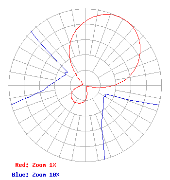 | ||||||||||||||||||
| Azimuth | Ratio | Azimuth | Ratio | Azimuth | Ratio | Azimuth | Ratio | ||||||||||||
| 0 | 0.829 | 10 | 0.920 | 20 | 0.979 | 30 | 1.000 | ||||||||||||
| 40 | 0.979 | 50 | 0.920 | 60 | 0.829 | 70 | 0.715 | ||||||||||||
| 80 | 0.570 | 90 | 0.388 | 100 | 0.187 | 110 | 0.045 | ||||||||||||
| 120 | 0.030 | 130 | 0.032 | 140 | 0.037 | 150 | 0.046 | ||||||||||||
| 160 | 0.065 | 170 | 0.142 | 180 | 0.202 | 190 | 0.234 | ||||||||||||
| 200 | 0.250 | 210 | 0.260 | 220 | 0.250 | 230 | 0.234 | ||||||||||||
| 240 | 0.202 | 250 | 0.142 | 260 | 0.065 | 270 | 0.046 | ||||||||||||
| 280 | 0.037 | 290 | 0.032 | 300 | 0.030 | 310 | 0.045 | ||||||||||||
| 320 | 0.187 | 330 | 0.388 | 340 | 0.570 | 350 | 0.715 | ||||||||||||
Structure Registration Number 1015316 Structure Type: GTOWER Registered To: WFMJ TELEVISION INC DBA = WFMJ Structure Address: 750 Mabel St Youngstown, OH County Name: Mahoning County ASR Issued: 09/18/2013 Date Built: 12/03/2013 Site Elevation: 314.9 m (1033 ft.) Structure Height: 292 m (958 ft.) Height Overall: 311.2 m (1021 ft.) Overall Height AMSL: 626.1 m (2054 ft.) FAA Determination: 09/10/2013 FAA Study #: 2013-AGL-8829-OE Paint & Light FAA Chapters: 1, 3, 7, 16, 21 PRIOR STUDY 2006-AGL-3581-OE OM&l PAINT/RED LIGHTS (FCC PARAGRAPHS) ADD SPECIAL CONDITION FOR LIGHTING DEVIATION. 41-04-48.6 N 80-38-24.4 W (NAD 83) 41-04-48.4 N 80-38-25.1 W (Converted to NAD 27) |
10058 Fox Den Road Ellicott City, MD 21042-2244 Phone: 443-487-3312 | Date: 04/22/2019 Application Certifier VCI RADIO, INC. 16271 Conneaut Lake Road Suite 102 Meadville, PA 16335 Applicant JOSEPH M VILKIE 16271 Conneaut Lake Rd Suite 102 Meadville, PA 16335 PRESIDENT MARISSA G. REPP, ESQ. Repp Law Firm 1629 K Street, Nw Suite 300 Washington, DC 20006-1631 | |||||||||||||||||