
FCCInfo.com
A Service of Cavell, Mertz & Associates, Inc.
(855) FCC-INFO
|
|
WRGC-FM from 11/27/2008 |
|  |
|
|||||||||||||||
|
|
WRGC-FM Channel: 202C3 88.3 MHz Milledgeville, Georgia Service: FM - A full-service FM station or application. Facility ID: 173100 Fac. Service: FM Analog & Digital Status: License Application Accepted: 02/17/2011 Application Granted: 02/24/2011 File Number: BLED-20110217AAV License Expires: 00/00/0000 Prefix Type: This is a license for a noncommercial educational FM station Application Type: License To Cover FCC Website Links: LMS Facility Details This Application CDBS Application Other WRGC-FM Applications Other WRGC-FM Applications in CDBS Including Superseded Applications Mailing Address Correspondence for WRGC-FM Correspondence related to application BLED-20110217AAV Service Contour - Open Street Map or USGS Map (60 dBu) Service Contour - KML / Google Earth (60 dBu) Public Inspection Files Facility Type: NON-COMMERCIAL EDUC. FM Class: C3, A Zone II station; with 6kW-25kW ERP and a class contour distance 28km-39km Site Location: 33-04-05.5 N 83-16-29.6 W (NAD 83) Site Location: 33-04-05.0 N 83-16-30.0 W (Converted to NAD 27) Effective Radiated Power: 4.8 kW Horiz. ; 4.3 kW Vert. Transmitter Output Power: 1.53 kW Antenna Center HAAT: 117 m (384 ft.) Antenna Center AMSL: 239 m (784 ft.) Antenna Center HAG: 87 m (285 ft.) Calculated Site Elevation: 152 m. (499 ft.) Height Overall*: 98 m (322 ft.) (* As Filed In This Application, may differ from ASR Data, Below.) Directional Antenna Antenna Make/Model: Shivley 6810-3R-DA Antenna ID: 81857 Polarization: | ||||||||||||||||||
| Antenna Data for Antenna Id: 81857 WRGC-FM FM File: BLED-20110217AAV Shivley - 6810-3R-DA Service: FM | 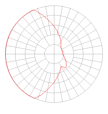 | ||||||||||||||||||
| Azimuth | Ratio | Azimuth | Ratio | Azimuth | Ratio | Azimuth | Ratio | ||||||||||||
| 0 | 0.566 | 10 | 0.450 | 20 | 0.358 | 30 | 0.285 | ||||||||||||
| 40 | 0.227 | 50 | 0.190 | 60 | 0.180 | 70 | 0.178 | ||||||||||||
| 80 | 0.178 | 90 | 0.178 | 100 | 0.202 | 110 | 0.232 | ||||||||||||
| 120 | 0.281 | 130 | 0.330 | 140 | 0.370 | 150 | 0.300 | ||||||||||||
| 160 | 0.370 | 170 | 0.465 | 180 | 0.585 | 190 | 0.736 | ||||||||||||
| 200 | 0.926 | 204 | 1.000 | 210 | 1.000 | 220 | 1.000 | ||||||||||||
| 230 | 1.000 | 240 | 1.000 | 250 | 1.000 | 260 | 1.000 | ||||||||||||
| 270 | 1.000 | 280 | 1.000 | 290 | 1.000 | 300 | 1.000 | ||||||||||||
| 310 | 1.000 | 320 | 1.000 | 330 | 1.000 | 335 | 1.000 | ||||||||||||
| 340 | 0.896 | 350 | 0.712 | ||||||||||||||||
Structure Registration Number 1020381 Structure Type: TOWER Registered To: GEORGIA, STATE OF Structure Address: Ga Hwy 49 At City Limits Milledgeville, GA County Name: Baldwin County ASR Issued: 06/06/2007 Date Built: 01/01/1971 Site Elevation: 152 m (499 ft.) Structure Height: 91 m (299 ft.) Height Overall: 98 m (322 ft.) Overall Height AMSL: 250 m (820 ft.) Paint & Light FAA Chapters: 1, 3, 12, 21 33-04-06.0 N 83-16-30.0 W (NAD 83) 33-04-05.5 N 83-16-30.4 W (Converted to NAD 27) |
Campus Box 97 Milledgville, GA 31061-3375 Phone: 478-445-6804 Government Entity | Date: 02/17/2011 Application Certifier GEORGIA COLLEGE & STATE UNIVERSITY Campus Box 97 Milledgville, GA 31061-3375 Applicant DANIEL L. DAVIS Po Box 48 Madison, GA 30650-0048 TECHNICAL CONSULTANT HARRY BATTSON Georgia College & State University | |||||||||||||||||