
FCCInfo.com
A Service of Cavell, Mertz & Associates, Inc.
(855) FCC-INFO
|
|
|
|
|
||||||||||||||||
|
|
WULV Channel: 204B1 88.7 MHz Moundsville, West Virginia Service: FM - A full-service FM station or application. Facility ID: 175587 Fac. Service: FM Status: License Application Accepted: 04/27/2015 Application Granted: 04/28/2015 File Number: BMLED-20150427AAR License Expires: 00/00/0000 Prefix Type: This is a modification of license for a noncommercial educational FM station Application Type: Minor Modification FCC Website Links: LMS Facility Details This Application CDBS Application Other WULV Applications Other WULV Applications in CDBS Including Superseded Applications Mailing Address Correspondence for WULV Correspondence related to application BMLED-20150427AAR Service Contour - Open Street Map or USGS Map (60 dBu) Service Contour - KML / Google Earth (60 dBu) Public Inspection Files Facility Type: NON-COMMERCIAL EDUC. FM Class: B1, A Zone I or I-A station; with 6kW-25kW ERP and a class contour distance 28km-39km Site Location: 39-50-51.3 N 80-45-22.3 W (NAD 83) Site Location: 39-50-51.0 N 80-45-23.0 W (Converted to NAD 27) Effective Radiated Power: 3 kW Transmitter Output Power: 1.815 kW Antenna Center HAAT: 181 m (594 ft.) Antenna Center AMSL: 498 m (1634 ft.) Antenna Center HAG: 58 m (190 ft.) Calculated Site Elevation: 440 m. (1444 ft.) Height Overall*: 62 m (203 ft.) (* As Filed In This Application, may differ from ASR Data, Below.) Directional Antenna Antenna Make/Model: Electronics Research Inc. 1092-1CP-DA Antenna ID: 81665 Polarization:
| ||||||||||||||||||
| Antenna Data for Antenna Id: 81665 WULV FM File: BMLED-20150427AAR Electronics Research Inc. - 1092-1CP-DA Service: FM | 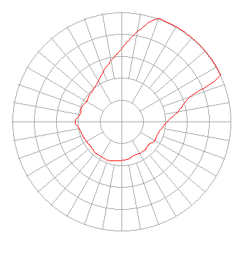 | ||||||||||||||||||
| Azimuth | Ratio | Azimuth | Ratio | Azimuth | Ratio | Azimuth | Ratio | ||||||||||||
| 0 | 0.664 | 10 | 0.835 | 20 | 1.000 | 30 | 1.000 | ||||||||||||
| 40 | 1.000 | 50 | 1.000 | 60 | 1.000 | 65 | 1.000 | ||||||||||||
| 70 | 0.663 | 80 | 0.527 | 90 | 0.418 | 100 | 0.372 | ||||||||||||
| 110 | 0.348 | 120 | 0.350 | 130 | 0.327 | 140 | 0.337 | ||||||||||||
| 150 | 0.335 | 160 | 0.330 | 170 | 0.349 | 180 | 0.355 | ||||||||||||
| 190 | 0.367 | 200 | 0.374 | 210 | 0.370 | 220 | 0.373 | ||||||||||||
| 230 | 0.363 | 240 | 0.366 | 250 | 0.378 | 260 | 0.391 | ||||||||||||
| 270 | 0.424 | 280 | 0.384 | 290 | 0.387 | 300 | 0.369 | ||||||||||||
| 310 | 0.382 | 320 | 0.392 | 330 | 0.424 | 340 | 0.484 | ||||||||||||
| 350 | 0.561 | ||||||||||||||||||
Structure Registration Number 1033711 Structure Type: TOWER Registered To: Educational Media Foundation Structure Address: Riggs Knob, On Taylors Ridge Road Moundsville, WV County Name: Marshall County ASR Issued: 05/14/2008 Date Built: 07/01/1989 Site Elevation: 440.1 m (1444 ft.) Structure Height: 61 m (200 ft.) Height Overall: 62.1 m (204 ft.) Overall Height AMSL: 502.2 m (1648 ft.) FAA Determination: 09/16/1997 FAA Study #: 97-AEA-2196-OE FAA Circular #: 70/7460-1J Paint & Light FAA Chapters: 3, 4, 5, 13 39-50-51.0 N 80-45-22.0 W (NAD 83) 39-50-50.7 N 80-45-22.7 W (Converted to NAD 27) |
5700 West Oaks Blvd. Rocklin, CA 95765 Phone: 916-251-1600 Not-for-Profit | Date: 04/27/2015 Application Certifier EDUCATIONAL MEDIA FOUNDATION 5700 West Oaks Blvd Rocklin, CA 95765 Applicant STEPHEN WILDE 5700 West Oaks Blvd Rocklin, CA 95765 BROADCAST ENGINEER MARY N. O'CONNOR Wilkinson Barker Knauer, Llp | |||||||||||||||||