
FCCInfo.com
A Service of Cavell, Mertz & Associates, Inc.
(855) FCC-INFO
|
|
|
|
|
||||||||||||||||
|
|
KIVM Channel: 216A 91.1 MHz Fredericksburg, Texas Service: FM - A full-service FM station or application. Facility ID: 171707 Fac. Service: FM Status: License Application Accepted: 02/17/2012 Application Granted: 03/07/2012 File Number: BLED-20120217ABU License Expires: 00/00/0000 Prefix Type: This is a license for a noncommercial educational FM station Application Type: License To Cover FCC Website Links: LMS Facility Details This Application CDBS Application Other KIVM Applications Other KIVM Applications in CDBS Including Superseded Applications Mailing Address Correspondence for KIVM Correspondence related to application BLED-20120217ABU Service Contour - Open Street Map or USGS Map (60 dBu) Service Contour - KML / Google Earth (60 dBu) Public Inspection Files Facility Type: NON-COMMERCIAL EDUC. FM Class: A, A Zone I; I-A; or II station; with 0.1kW-6kW ERP and a class contour distance <=28km Site Location: 30-21-51.7 N 98-54-43.2 W (NAD 83) Site Location: 30-21-51.0 N 98-54-42.0 W (Converted to NAD 27) Effective Radiated Power: 1 kW Transmitter Output Power: 0.89 kW Antenna Center HAAT: 151 m (495 ft.) Antenna Center AMSL: 734 m (2408 ft.) Antenna Center HAG: 76 m (249 ft.) Calculated Site Elevation: 658 m. (2159 ft.) Height Overall*: 106.1 m (348 ft.) (* As Filed In This Application, may differ from ASR Data, Below.) Directional Antenna Antenna Make/Model: Shivley 6810-1-DA Antenna ID: 103316 Polarization:
| ||||||||||||||||||
| Antenna Data for Antenna Id: 103316 KIVM FM File: BLED-20120217ABU Shivley - 6810-1-DA Service: FM | 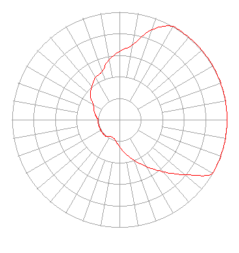 | ||||||||||||||||||
| Azimuth | Ratio | Azimuth | Ratio | Azimuth | Ratio | Azimuth | Ratio | ||||||||||||
| 0 | 0.632 | 10 | 0.708 | 20 | 0.890 | 30 | 1.000 | ||||||||||||
| 40 | 1.000 | 50 | 1.000 | 60 | 1.000 | 70 | 1.000 | ||||||||||||
| 80 | 1.000 | 90 | 1.000 | 100 | 1.000 | 110 | 1.000 | ||||||||||||
| 120 | 1.000 | 130 | 0.795 | 140 | 0.632 | 150 | 0.503 | ||||||||||||
| 160 | 0.400 | 170 | 0.317 | 180 | 0.252 | 190 | 0.200 | ||||||||||||
| 200 | 0.178 | 210 | 0.178 | 220 | 0.200 | 230 | 0.200 | ||||||||||||
| 240 | 0.200 | 250 | 0.200 | 260 | 0.200 | 270 | 0.200 | ||||||||||||
| 280 | 0.225 | 290 | 0.252 | 300 | 0.283 | 310 | 0.356 | ||||||||||||
| 320 | 0.400 | 330 | 0.448 | 340 | 0.475 | 350 | 0.563 | ||||||||||||
Structure Registration Number 1276790 Structure Type: TOWER Registered To: Highpoint Wireless, Inc. Structure Address: 404 Kirchen Berg Rd. Fredericksburg, TX County Name: Gillespie County ASR Issued: 11/19/2010 Date Built: 06/03/2011 Site Elevation: 658.1 m (2159 ft.) Structure Height: 99.1 m (325 ft.) Height Overall: 106.1 m (348 ft.) Overall Height AMSL: 764.2 m (2507 ft.) FAA Determination: 07/06/2010 FAA Study #: 2010-ASW-3322-OE FAA Circular #: 70/7460-1K Paint & Light FAA Chapters: 4, 8, 12 Removed expiration date from determination. Scenario 1./jjs/case#635066 30-21-51.5 N 98-54-43.5 W (NAD 83) 30-21-50.8 N 98-54-42.3 W (Converted to NAD 27) |
1406 E. Garden Lane Midland, TX 79701 Phone: 888-784-3476 Not-for-Profit | Date: 02/17/2012 Application Certifier LA PROMESA FOUNDATION 1406 E. Garden Lane Midland, TX 79701 Applicant ROBERT WALKER Post Office Box 28961 Austin, TX 78755 ATTORNEY/CONSULTANT DENNIS J. KELLY Law Office Of Dennis J. Kelly | |||||||||||||||||