
FCCInfo.com
A Service of Cavell, Mertz & Associates, Inc.
(855) FCC-INFO
|
|
|
|
|
||||||||||||||||
|
|
K220EO Channel: 220D 91.9 MHz Hilo, Hawaii Service: FX - A translator or application for a translator. Facility ID: 43688 Fac. Service: FX Programming Delivery Method: Unspecified Status: License Application Accepted: 09/10/2015 Application Granted: 10/01/2015 File Number: BLFT-20150910AAF License Expires: 00/00/0000 Prefix Type: This is a license for a translator Application Type: License To Cover FCC Website Links: LMS Facility Details This Application CDBS Application Other K220EO Applications Other K220EO Applications in CDBS Including Superseded Applications Mailing Address Correspondence for K220EO Correspondence related to application BLFT-20150910AAF Service Contour - Open Street Map or USGS Map (60 dBu) Service Contour - KML / Google Earth (60 dBu) Class: D, A Noncommercial educational operating with no more than 10W Site Location: 19-43-00.0 N 155-08-13.0 W (NAD 83) Site Location: 19-43-10.9 N 155-08-23.0 W (Converted to NAD 27) Effective Radiated Power: 0.25 kW Transmitter Output Power: 0.111 kW Antenna Center HAAT: -140.3 m Horiz.; 0 m Vert. Antenna Center AMSL: 300 m (984 ft.) Antenna Center HAG: 37 m (121 ft.) Site Elevation: 263 m. (863 ft.) Height Overall*: 80 m (262 ft.) (* As Filed In This Application, may differ from ASR Data, Below.) Directional Antenna Antenna Make/Model: None Antenna ID: 110376 Polarization:
| ||||||||||||||||||
| Antenna Data for Antenna Id: 110376 K220EO FX File: BLFT-20150910AAF None - Service: FX | 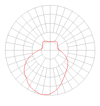 | ||||||||||||||||||
| Azimuth | Ratio | Azimuth | Ratio | Azimuth | Ratio | Azimuth | Ratio | ||||||||||||
| 0 | 0.180 | 10 | 0.190 | 20 | 0.205 | 30 | 0.231 | ||||||||||||
| 40 | 0.236 | 50 | 0.222 | 60 | 0.193 | 70 | 0.173 | ||||||||||||
| 80 | 0.179 | 90 | 0.206 | 100 | 0.273 | 110 | 0.359 | ||||||||||||
| 120 | 0.445 | 130 | 0.519 | 140 | 0.574 | 150 | 0.652 | ||||||||||||
| 160 | 0.761 | 170 | 0.882 | 180 | 0.970 | 190 | 1.000 | ||||||||||||
| 200 | 0.963 | 210 | 0.909 | 220 | 0.818 | 230 | 0.747 | ||||||||||||
| 240 | 0.639 | 250 | 0.501 | 260 | 0.355 | 270 | 0.242 | ||||||||||||
| 280 | 0.184 | 290 | 0.174 | 300 | 0.188 | 310 | 0.216 | ||||||||||||
| 320 | 0.233 | 330 | 0.230 | 340 | 0.206 | 350 | 0.184 | ||||||||||||
Structure Registration Number 1029536 Structure Type: TOWER Registered To: Nexstar Media Inc. Structure Address: 2.1 Km Nw Of Intersection Waianuenue & Akola Piihonua, HI County Name: Hawaii County ASR Issued: 05/28/2021 Date Built: 01/01/1967 Site Elevation: 262.7 m (862 ft.) Structure Height: 78.6 m (258 ft.) Height Overall: 79.6 m (261 ft.) Overall Height AMSL: 342.3 m (1123 ft.) Paint & Light FAA Chapters: 1, 3, 11, 21 19-42-49.0 N 155-08-03.0 W (NAD 83) 19-42-59.9 N 155-08-13.0 W (Converted to NAD 27) |
820 N Lasalle St Chicago, IL 60610-3214 Phone: 312-329-4438 | Date: 09/10/2015 Application Certifier THE MOODY BIBLE INSTITUTE OF CHICAGO 820 North Lasalle Boulevard Chicago, IL 60610-3284 Applicant JEFFREY D SOUTHMAYD Southmayd & Miller 4 Palm Coast, FL 32137 ATTORNEY JEFFREY D. SOUTHMAYD Southmayd & Miller 4 Ocean Ridge Boulevard South Palm Coast, FL 32137 | |||||||||||||||||