
FCCInfo.com
A Service of Cavell, Mertz & Associates, Inc.
(855) FCC-INFO
|
|
|
|  |
|
||||||||||||||||||
|
|
WAYF Channel: 201C1 88.1 MHz West Palm Beach, Florida Service: FM - A full-service FM station or application. Facility ID: 61507 Fac. Service: FM Status: License Application Accepted: 08/18/2003 Application Granted: 08/26/2003 File Number: BLED-20030818ADR License Expires: 00/00/0000 Prefix Type: This is a license for a noncommercial educational FM station Application Type: License To Cover FCC Website Links: LMS Facility Details This Application CDBS Application Other WAYF Applications Other WAYF Applications in CDBS Including Superseded Applications Mailing Address Correspondence for WAYF Correspondence related to application BLED-20030818ADR Service Contour - Open Street Map or USGS Map (60 dBu) Service Contour - KML / Google Earth (60 dBu) Public Inspection Files Facility Type: NON-COMMERCIAL EDUC. FM Class: C1, A Zone II station; with 50kW-100kW ERP and a class contour distance 52km-72km Site Location: 26-35-21.2 N 80-12-43.2 W (NAD 83) Site Location: 26-35-20.0 N 80-12-44.0 W (Converted to NAD 27) Effective Radiated Power: 0.05 kW Horiz. ; 50 kW Vert. Transmitter Output Power: 11.48 kW Antenna Center HAAT: 321 m (1053 ft.) Antenna Center AMSL: 322.5 m (1058 ft.) Antenna Center HAG: 317 m (1040 ft.) Site Elevation: 5.5 m. (18 ft.) Height Overall*: 405.7 m (1331 ft.) (* As Filed In This Application, may differ from ASR Data, Below.) Directional Antenna Antenna Make/Model: Electronics Research Inc. PAN303-3B-DA Antenna ID: 43945 Polarization:
| |||||||||||||||||||||
| Antenna Data for Antenna Id: 43945 WAYF FM File: BLED-20030818ADR Electronics Research Inc. - PAN303-3B-DA Service: FM | 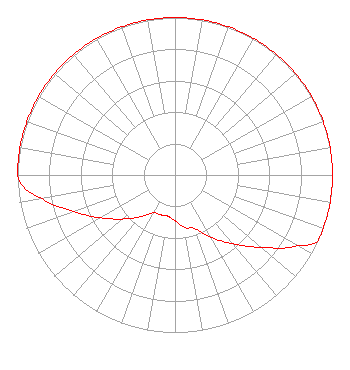 | |||||||||||||||||||||
| Azimuth | Ratio | Azimuth | Ratio | Azimuth | Ratio | Azimuth | Ratio | |||||||||||||||
| 0 | 1.000 | 10 | 1.000 | 20 | 1.000 | 30 | 1.000 | |||||||||||||||
| 40 | 1.000 | 50 | 1.000 | 60 | 1.000 | 70 | 1.000 | |||||||||||||||
| 80 | 1.000 | 90 | 1.000 | 100 | 1.000 | 110 | 1.000 | |||||||||||||||
| 115 | 1.000 | 120 | 0.897 | 130 | 0.716 | 140 | 0.570 | |||||||||||||||
| 150 | 0.456 | 160 | 0.363 | 170 | 0.338 | 180 | 0.290 | |||||||||||||||
| 190 | 0.266 | 200 | 0.269 | 210 | 0.277 | 220 | 0.347 | |||||||||||||||
| 230 | 0.435 | 240 | 0.545 | 250 | 0.683 | 260 | 0.856 | |||||||||||||||
| 265 | 0.958 | 270 | 1.000 | 280 | 1.000 | 290 | 1.000 | |||||||||||||||
| 300 | 1.000 | 310 | 1.000 | 320 | 1.000 | 330 | 1.000 | |||||||||||||||
| 340 | 1.000 | 350 | 1.000 | |||||||||||||||||||
Structure Registration Number 1220033 [ASR Heights Differ from WAYF Application] Structure Type: TOWER Registered To: SCRIPPS MEDIA, INC. Structure Address: Near Intersection Of Us Hwy 441 And Lantana Road Greenacres City, FL County Name: Palm Beach County ASR Issued: 09/11/2013 Date Built: 06/19/2009 Site Elevation: 5.5 m (18 ft.) Structure Height: 377.3 m (1238 ft.) Height Overall: 395 m (1296 ft.) Overall Height AMSL: 400.5 m (1314 ft.) FAA Determination: 09/27/2010 FAA Study #: 2010-ASO-4579-OE FAA Circular #: 70/7460-1K Paint & Light FAA Chapters: 4, 7, 12 PRIOR STUDY 2000-ASO-790-OE 26-35-21.2 N 80-12-42.8 W (NAD 83) 26-35-20.0 N 80-12-43.6 W (Converted to NAD 27) |
1722 Treble Drive Humble, TX 77338 Phone: 214-353-9293 Not-for-Profit | Date: 08/18/2003 Application Certifier WAY MEDIA , INC. P.o. Box 64500 Colorado Springs, CO 80962 Applicant LAURA M. MIZRAHI Communications Technologies, Inc. P.o. Box 1130 Marlton, NJ 08053 TECHNICAL CONSULTANT A. WRAY FITCH III Gammon & Grange, P.c. | ||||||||||||||||||||
| ||||||||||||||||||||||