
FCCInfo.com
A Service of Cavell, Mertz & Associates, Inc.
(855) FCC-INFO
|
|
KKER from 12/08/2000 KKER from 01/20/1998 |
|
|
||||||||||||||||
|
|
KKER Channel: 204C1 88.7 MHz Kerrville, Texas Service: FM - A full-service FM station or application. Facility ID: 84182 Fac. Service: FM Status: License Application Accepted: 06/16/2005 Application Granted: 11/14/2005 File Number: BLED-20050616AAW License Expires: 00/00/0000 Prefix Type: This is a license for a noncommercial educational FM station Application Type: Amendment FCC Website Links: LMS Facility Details This Application CDBS Application Other KKER Applications Other KKER Applications in CDBS Including Superseded Applications Mailing Address Correspondence for KKER Correspondence related to application BLED-20050616AAW Service Contour - Open Street Map or USGS Map (60 dBu) Service Contour - KML / Google Earth (60 dBu) Public Inspection Files Facility Type: NON-COMMERCIAL EDUC. FM Class: C1, A Zone II station; with 50kW-100kW ERP and a class contour distance 52km-72km Site Location: 30-03-30.8 N 99-03-51.1 W (NAD 83) Site Location: 30-03-30.0 N 99-03-50.0 W (Converted to NAD 27) Effective Radiated Power: 52 kW Transmitter Output Power: 6.5 kW Antenna Center HAAT: 174 m (571 ft.) Antenna Center AMSL: 727 m (2385 ft.) Antenna Center HAG: 116 m (381 ft.) Site Elevation: 611 m. (2005 ft.) Height Overall*: 128 m (420 ft.) (* As Filed In This Application, may differ from ASR Data, Below.) Directional Antenna Antenna Make/Model: Electronics Research Inc. MP-8C-DA, eight sections Antenna ID: 68921 Polarization:
| ||||||||||||||||||
| Antenna Data for Antenna Id: 68921 KKER FM File: BLED-20050616AAW Electronics Research Inc. - MP-8C-DA, eight sections Service: FM | 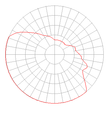 | ||||||||||||||||||
| Azimuth | Ratio | Azimuth | Ratio | Azimuth | Ratio | Azimuth | Ratio | ||||||||||||
| 0 | 0.300 | 10 | 0.300 | 20 | 0.300 | 30 | 0.300 | ||||||||||||
| 40 | 0.300 | 50 | 0.300 | 60 | 0.360 | 70 | 0.440 | ||||||||||||
| 75 | 0.440 | 80 | 0.440 | 85 | 0.470 | 90 | 0.510 | ||||||||||||
| 95 | 0.550 | 100 | 0.570 | 110 | 0.710 | 120 | 0.665 | ||||||||||||
| 125 | 0.710 | 130 | 0.795 | 140 | 1.000 | 150 | 1.000 | ||||||||||||
| 160 | 1.000 | 170 | 1.000 | 180 | 1.000 | 190 | 1.000 | ||||||||||||
| 200 | 1.000 | 210 | 1.000 | 220 | 1.000 | 230 | 1.000 | ||||||||||||
| 240 | 1.000 | 250 | 1.000 | 260 | 1.000 | 270 | 1.000 | ||||||||||||
| 280 | 1.000 | 290 | 1.000 | 300 | 0.880 | 310 | 0.700 | ||||||||||||
| 320 | 0.560 | 330 | 0.450 | 340 | 0.400 | 350 | 0.350 | ||||||||||||
Structure Registration Number 1247051 Structure Type: GTOWER Registered To: Houston Christian Broadcasters, Inc Structure Address: 2935 Cypress Creek Road (5 Mi E Of Kerville) Kerville, TX County Name: Kerr County ASR Issued: 05/05/2014 Date Built: 02/02/2006 Site Elevation: 611.1 m (2005 ft.) Structure Height: 127.1 m (417 ft.) Height Overall: 128 m (420 ft.) Overall Height AMSL: 739.1 m (2425 ft.) FAA Determination: 02/05/2013 FAA Study #: 2013-ASW-625-OE FAA Circular #: 70/7460-1K Paint & Light FAA Chapters: 4, 8, 12 PRIOR STUDY 2004-ASW-4478-OE CHAPTERS 4,8,12 (1K) ADD SPECIAL CONDITION FOR LIGHTING DEVIATION. 30-03-31.0 N 99-03-51.1 W (NAD 83) 30-03-30.2 N 99-03-50.0 W (Converted to NAD 27) |
2424 South Blvd Houston, TX 77098 Phone: 713-520-5200 Not-for-Profit | Date: 06/16/2005 Application Certifier HOUSTON CHRISTIAN BROADCASTERS, INC. 2424 South Boulevard Houston, TX 77098-5196 Applicant JEFFREY D. SOUTHMAYD Southmayd & Miller 1220 19th Street Nw #400 Washington, DC 20036 ATTORNEY JEFFREY D. SOUTHMAYD Southmayd & Miller | |||||||||||||||||