
FCCInfo.com
A Service of Cavell, Mertz & Associates, Inc.
(855) FCC-INFO
|
|
W234CU from 01/28/2016 W234CU from 06/15/2015 W234CU from 06/23/2004 |
|
|
||||||||||||||||
|
|
W234CU Channel: 234D 94.7 MHz Knoxville, Tennessee Service: FX - A translator or application for a translator. Facility ID: 153535 Fac. Service: FX Programming Delivery Method: Unspecified Status: License Application Accepted: 12/12/2016 Application Granted: 12/16/2016 File Number: BLFT-20161212AAD License Expires: 00/00/0000 Prefix Type: This is a license for a translator Application Type: License To Cover FCC Website Links: LMS Facility Details This Application CDBS Application Other W234CU Applications Other W234CU Applications in CDBS Including Superseded Applications Mailing Address Correspondence for W234CU Correspondence related to application BLFT-20161212AAD Service Contour - Open Street Map or USGS Map (60 dBu) Service Contour - KML / Google Earth (60 dBu) Class: D, A Noncommercial educational operating with no more than 10W Site Location: 36-00-08.3 N 83-56-40.7 W (NAD 83) Site Location: 36-00-08.0 N 83-56-41.0 W (Converted to NAD 27) Effective Radiated Power: 0 kW Horiz. ; 0.25 kW Vert. Transmitter Output Power: 0.271 kW Antenna Center HAAT: 0 m Antenna Center AMSL: 0 m Horiz.; 455 m Vert. Antenna Center HAG: 0 m Horiz.; 50 m Vert. Site Elevation: 405 m. (1329 ft.) Height Overall*: 61 m (200 ft.) (* As Filed In This Application, may differ from ASR Data, Below.) Directional Antenna Antenna Make/Model: None Antenna ID: 124835 Polarization:
| ||||||||||||||||||
| Antenna Data for Antenna Id: 124835 W234CU FX File: BLFT-20161212AAD None - Service: FX | 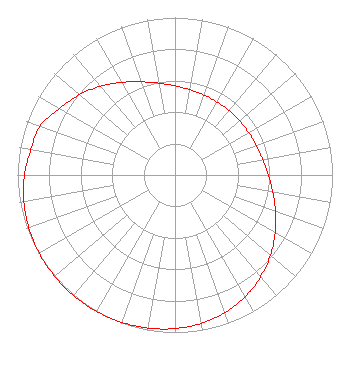 | ||||||||||||||||||
| Azimuth | Ratio | Azimuth | Ratio | Azimuth | Ratio | Azimuth | Ratio | ||||||||||||
| 0 | 0.566 | 10 | 0.549 | 20 | 0.540 | 30 | 0.535 | ||||||||||||
| 40 | 0.534 | 50 | 0.535 | 60 | 0.540 | 70 | 0.549 | ||||||||||||
| 80 | 0.566 | 90 | 0.592 | 100 | 0.630 | 110 | 0.679 | ||||||||||||
| 120 | 0.735 | 130 | 0.792 | 140 | 0.845 | 150 | 0.892 | ||||||||||||
| 160 | 0.929 | 170 | 0.956 | 180 | 0.975 | 190 | 0.987 | ||||||||||||
| 200 | 0.995 | 210 | 0.999 | 220 | 1.000 | 230 | 0.999 | ||||||||||||
| 240 | 0.995 | 250 | 0.987 | 260 | 0.975 | 270 | 0.956 | ||||||||||||
| 280 | 0.929 | 290 | 0.910 | 300 | 0.845 | 310 | 0.792 | ||||||||||||
| 320 | 0.735 | 330 | 0.679 | 340 | 0.630 | 350 | 0.592 | ||||||||||||
Structure Registration Number 1000295 Structure Type: TOWER Structure Address: 331 Sharp Ridge Memorial Dr Knoxville, TN County Name: Knox County ASR Issued: 07/01/2008 Date Built: 01/01/1989 Site Elevation: 405.4 m (1330 ft.) Structure Height: 61 m (200 ft.) Height Overall: 61 m (200 ft.) Overall Height AMSL: 466.4 m (1530 ft.) FAA Determination: 09/19/1991 FAA Study #: 89-ASO-0115-OE Paint & Light FAA Chapters: NONE 36-00-08.0 N 83-56-41.0 W (NAD 83) 36-00-07.7 N 83-56-41.3 W (Converted to NAD 27) |
818 North Cedar Bluff Road Knoxville, TN 37923 Phone: 865-690-0855 | Date: 12/12/2016 Application Certifier PROGRESSIVE MEDIA INC. 818n Cedar Bluff Road Knoxville, TN 37923 Applicant LARRY PERRY Attorney 11464 Saga Lane Suite 400 Knoxville, TN 37931-2819 CONSULTING ENGINEER LARRY PERRY Attorney 11464 Saga Lane Sutie 400 Knoxville,, TN 37931-2819 | |||||||||||||||||