
FCCInfo.com
A Service of Cavell, Mertz & Associates, Inc.
(855) FCC-INFO
|
|
WLXF from 09/04/2009 WLXF from 06/20/2005 WLXF from 12/26/2000 WLXF from 04/14/1980 |
|
|
||||||||||||||||
|
|
WLXF Channel: 288C3 105.5 MHz Macon, Georgia Service: FM - A full-service FM station or application. Facility ID: 68679 Fac. Service: FM Status: License 73.215 Station Application Accepted: 03/29/2016 Application Granted: 06/06/2016 File Number: BMLED-20160329ABX License Expires: 00/00/0000 Prefix Type: This is a modification of license for a noncommercial educational FM station Application Type: Minor Modification FCC Website Links: LMS Facility Details This Application CDBS Application Other WLXF Applications Other WLXF Applications in CDBS Including Superseded Applications Mailing Address Correspondence for WLXF Correspondence related to application BMLED-20160329ABX Service Contour - Open Street Map or USGS Map (60 dBu) Service Contour - KML / Google Earth (60 dBu) Public Inspection Files History Cards for WLXF Facility Type: NON-COMMERCIAL EDUC. FM Class: C3, A Zone II station; with 6kW-25kW ERP and a class contour distance 28km-39km Site Location: 32-53-48.5 N 83-32-04.6 W (NAD 83) Site Location: 32-53-48.0 N 83-32-05.0 W (Converted to NAD 27) Effective Radiated Power: 6.1 kW Transmitter Output Power: 4.34 kW Antenna Center HAAT: 201 m (659 ft.) Antenna Center AMSL: 339 m (1112 ft.) Antenna Center HAG: 144 m (472 ft.) Site Elevation: 195 m. (640 ft.) Height Overall*: 152 m (499 ft.) (* As Filed In This Application, may differ from ASR Data, Below.) Directional Antenna Antenna Make/Model: Electronics Research Inc. LP-4E-DA-HW, four sections Antenna ID: 31638 Polarization: | ||||||||||||||||||
| Antenna Data for Antenna Id: 31638 WLXF FM File: BMLED-20160329ABX Electronics Research Inc. - LP-4E-DA-HW, four sections Service: FM | 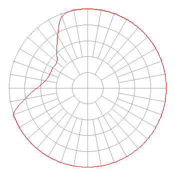 | ||||||||||||||||||
| Azimuth | Ratio | Azimuth | Ratio | Azimuth | Ratio | Azimuth | Ratio | ||||||||||||
| 0 | 1.000 | 10 | 1.000 | 20 | 1.000 | 30 | 1.000 | ||||||||||||
| 40 | 1.000 | 50 | 1.000 | 60 | 1.000 | 70 | 1.000 | ||||||||||||
| 80 | 1.000 | 90 | 1.000 | 100 | 1.000 | 110 | 1.000 | ||||||||||||
| 120 | 1.000 | 130 | 1.000 | 140 | 1.000 | 150 | 1.000 | ||||||||||||
| 160 | 1.000 | 170 | 1.000 | 180 | 1.000 | 190 | 1.000 | ||||||||||||
| 200 | 1.000 | 210 | 1.000 | 220 | 1.000 | 230 | 1.000 | ||||||||||||
| 240 | 1.000 | 250 | 1.000 | 260 | 0.808 | 270 | 0.641 | ||||||||||||
| 280 | 0.539 | 290 | 0.509 | 300 | 0.509 | 310 | 0.509 | ||||||||||||
| 320 | 0.605 | 330 | 0.757 | 340 | 0.954 | 350 | 1.000 | ||||||||||||
Structure Registration Number 1052145 Structure Type: TOWER Registered To: Clearview Tower Company II, LLC Structure Address: Hwy. 49 1.5 Miles (2.4km) N. Of Jones/bibb Co. Line Macon, GA County Name: Jones County ASR Issued: 01/18/2018 Date Built: 01/01/1981 Site Elevation: 195.1 m (640 ft.) Structure Height: 152.1 m (499 ft.) Height Overall: 152.1 m (499 ft.) Overall Height AMSL: 347.2 m (1139 ft.) FAA Determination: 06/09/1998 FAA Study #: 98-ASO-3631-OE FAA Circular #: 70/7460-1J Paint & Light FAA Chapters: 3, 4, 5, 13 32-53-48.0 N 83-32-05.0 W (NAD 83) 32-53-47.5 N 83-32-05.4 W (Converted to NAD 27) |
5700 West Oaks Blvd. Rocklin, CA 95765 Phone: 916-251-1600 Not-for-Profit | Date: 03/29/2016 Application Certifier EDUCATIONAL MEDIA FOUNDATION 5700 West Oaks Blvd. Rocklin, CA 95765 Applicant SAM WALLINGTON 5700 West Oaks Blvd. Rocklin, CA 95765 VP OF ENGINEERING MARY O'CONNOR Wilkinson Barker Knauer, Llp | |||||||||||||||||