
FCCInfo.com
A Service of Cavell, Mertz & Associates, Inc.
(855) FCC-INFO
|
|
KING-FM from 02/16/1995 KING-FM from 10/31/1980 |
|  |
|
||||||||||||||||||
|
|
KING-FM Channel: 251C 98.1 MHz Seattle, Washington Service: FM - A full-service FM station or application. Facility ID: 11755 Fac. Service: FM Analog & Digital Status: License Application Accepted: 05/02/2011 Application Granted: 06/28/2011 File Number: BMLED-20110502AEJ License Expires: 00/00/0000 Prefix Type: This is a modification of license for a noncommercial educational FM station Application Type: Minor Modification FCC Website Links: LMS Facility Details This Application CDBS Application Other KING-FM Applications Other KING-FM Applications in CDBS Including Superseded Applications Mailing Address Correspondence for KING-FM Correspondence related to application BMLED-20110502AEJ Service Contour - Open Street Map or USGS Map (60 dBu) Service Contour - KML / Google Earth (60 dBu) Public Inspection Files History Cards for KING-FM Facility Type: NON-COMMERCIAL EDUC. FM Class: C, A Zone II station; with exactly 100kW ERP and a class contour distance 72km-92km Site Location: 47-30-13.4 N 121-58-33.4 W (NAD 83) Site Location: 47-30-14.0 N 121-58-29.0 W (Converted to NAD 27) Effective Radiated Power: 68 kW Transmitter Output Power: 17.8 kW Antenna Center HAAT: 707 m (2320 ft.) Antenna Center AMSL: 940 m (3084 ft.) Antenna Center HAG: 41 m (135 ft.) Calculated Site Elevation: 899 m. (2949 ft.) Height Overall*: 61 m (200 ft.) (* As Filed In This Application, may differ from ASR Data, Below.) Directional Antenna Antenna Make/Model: Electronics Research Inc. 1082-4CP-DA Antenna ID: 72520 Polarization: | |||||||||||||||||||||
| Antenna Data for Antenna Id: 72520 KING-FM FM File: BMLED-20110502AEJ Electronics Research Inc. - 1082-4CP-DA Service: FM | 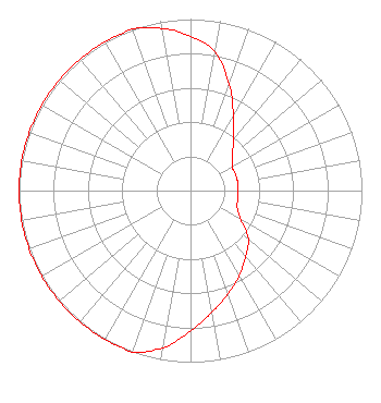 | |||||||||||||||||||||
| Azimuth | Ratio | Azimuth | Ratio | Azimuth | Ratio | Azimuth | Ratio | |||||||||||||||
| 0 | 0.901 | 10 | 0.820 | 20 | 0.660 | 30 | 0.500 | |||||||||||||||
| 40 | 0.390 | 50 | 0.320 | 60 | 0.280 | 70 | 0.280 | |||||||||||||||
| 80 | 0.280 | 90 | 0.279 | 100 | 0.280 | 110 | 0.290 | |||||||||||||||
| 120 | 0.340 | 130 | 0.440 | 140 | 0.500 | 150 | 0.570 | |||||||||||||||
| 160 | 0.640 | 170 | 0.720 | 180 | 0.819 | 190 | 0.930 | |||||||||||||||
| 200 | 1.000 | 210 | 1.000 | 220 | 1.000 | 230 | 1.000 | |||||||||||||||
| 240 | 1.000 | 250 | 1.000 | 260 | 1.000 | 270 | 1.000 | |||||||||||||||
| 280 | 1.000 | 290 | 1.000 | 300 | 1.000 | 310 | 1.000 | |||||||||||||||
| 320 | 1.000 | 330 | 1.000 | 340 | 1.000 | 350 | 0.960 | |||||||||||||||
Structure Registration Number 1056823 Structure Type: LTOWER Registered To: American Towers LLC Structure Address: 3.75 Miles S.e. Of Issaquah, Wa - On West Tiger Mtn. (#273577) Issaquah, WA County Name: King County ASR Issued: 12/07/2016 Date Built: 04/03/1988 Site Elevation: 898.6 m (2948 ft.) Structure Height: 61 m (200 ft.) Height Overall: 61 m (200 ft.) Overall Height AMSL: 959.6 m (3148 ft.) FAA Determination: 12/05/2016 FAA Study #: 2016-ANM-3387-OE Paint & Light FAA Chapters: NONE PRIOR STUDY 2016-ANM-2649-OE 47-30-13.0 N 121-58-33.0 W (NAD 83) 47-30-13.6 N 121-58-28.6 W (Converted to NAD 27) |
363 Mercer Street Suite 200 Seattle, WA 98109 Phone: 206-691-2981 Not-for-Profit | Date: 05/02/2011 Application Certifier CLASSIC RADIO, INC. 10 Harrison Street Suite 100 Seattle, WA 98109-4509 Applicant ERIK C. SWANSON, P.E. Hatfield & Dawson Consulting Engineers 9500 Greenwood Ave N Seattle, WA 98103 CONSULTING ENGINEER ERWIN G. KRASNOW, ESQ. Garvey Schubert Barer | ||||||||||||||||||||
|
| |||||||||||||||||||||