
FCCInfo.com
A Service of Cavell, Mertz & Associates, Inc.
(855) FCC-INFO
|
|
W283CR from 08/24/2004 |
|
|
||||||||||||||||
|
|
W283CR Channel: 283D 104.5 MHz Morgantown, West Virginia Service: FX - A translator or application for a translator. Facility ID: 143294 Fac. Service: FX Programming Delivery Method: Unspecified Status: License Application Accepted: 03/25/2019 Application Granted: 03/27/2019 File Number: BLFT-20190325AAF License Expires: 00/00/0000 Prefix Type: This is a license for a translator Application Type: License To Cover FCC Website Links: LMS Facility Details This Application CDBS Application Other W283CR Applications Other W283CR Applications in CDBS Including Superseded Applications Mailing Address Correspondence for W283CR Correspondence related to application BLFT-20190325AAF Service Contour - Open Street Map or USGS Map (60 dBu) Service Contour - KML / Google Earth (60 dBu) Class: D, A Noncommercial educational operating with no more than 10W Site Location: 39-36-29.0 N 79-59-06.0 W (NAD 83) Site Location: 39-36-28.7 N 79-59-06.8 W (Converted to NAD 27) Effective Radiated Power: 0.25 kW Transmitter Output Power: 0.035 kW Antenna Center HAAT: 0 m Antenna Center AMSL: 510 m (1673 ft.) Antenna Center HAG: 97 m (318 ft.) Site Elevation: 413 m. (1355 ft.) Height Overall*: 130 m (427 ft.) (* As Filed In This Application, may differ from ASR Data, Below.) Directional Antenna Antenna Make/Model: None Antenna ID: 126378 Polarization:
| ||||||||||||||||||
| Antenna Data for Antenna Id: 126378 W283CR FX File: BLFT-20190325AAF None - Service: FX Pattern and Field Values Include a 160° Clockwise Rotation | 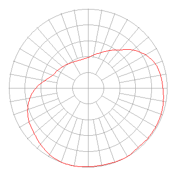 | ||||||||||||||||||
| Azimuth | Ratio | Azimuth | Ratio | Azimuth | Ratio | Azimuth | Ratio | ||||||||||||
| 0 | 0.384 | 10 | 0.423 | 20 | 0.475 | 30 | 0.545 | ||||||||||||
| 40 | 0.628 | 50 | 0.745 | 60 | 0.840 | 70 | 0.902 | ||||||||||||
| 80 | 0.929 | 90 | 0.945 | 100 | 0.966 | 110 | 0.981 | ||||||||||||
| 120 | 0.986 | 130 | 0.988 | 140 | 0.982 | 150 | 0.999 | ||||||||||||
| 160 | 0.995 | 170 | 0.990 | 180 | 0.996 | 190 | 1.000 | ||||||||||||
| 200 | 0.994 | 210 | 0.971 | 220 | 0.932 | 230 | 0.889 | ||||||||||||
| 240 | 0.860 | 250 | 0.811 | 260 | 0.744 | 270 | 0.656 | ||||||||||||
| 280 | 0.547 | 290 | 0.472 | 300 | 0.443 | 310 | 0.415 | ||||||||||||
| 320 | 0.395 | 330 | 0.378 | 340 | 0.368 | 350 | 0.369 | ||||||||||||
Structure Registration Number 1035671 Structure Type: TOWER Registered To: WEST VIRGINIA RADIO CORPORATION Structure Address: E Side Of Old Dupont Rd Morgantown, WV County Name: Monongalia County ASR Issued: 01/26/1998 Date Built: 01/01/1981 Site Elevation: 413 m (1355 ft.) Structure Height: 130.1 m (427 ft.) Height Overall: 130.1 m (427 ft.) Overall Height AMSL: 543.1 m (1782 ft.) FAA Determination: 02/15/1980 FAA Study #: 79-AEA-894-OE Paint & Light FAA Chapters: 1, 3, 12, 21 RED LIGHTS/PAINT 39-36-29.0 N 79-59-06.0 W (NAD 83) 39-36-28.7 N 79-59-06.8 W (Converted to NAD 27) |
1111 Virginia Street, E Charleston, WV 25301 Phone: 304-554-3900 | Date: 03/25/2019 Application Certifier WEST VIRGINIA RADIO CORPORATION 1251 Earl L. Core Road Morgantown, WV 26505 Applicant NOEL RICHARDSON 1111 Virginia Street E. Charleston, WV 25301 VICE-PRESIDENT/ENGINEERING MATTHEW H. MCCORMICK Fletcher, Heald & Hildreth, Plc 1300 North 17th Street 11th Floor Arlington, VA 22209 | |||||||||||||||||