
FCCInfo.com
A Service of Cavell, Mertz & Associates, Inc.
(855) FCC-INFO
|
|
KZLV from 07/20/1988 |
|
|
||||||||||||||||
|
|
KZLV Channel: 217C2 91.3 MHz Lytle, Texas Service: FM - A full-service FM station or application. Facility ID: 66441 Fac. Service: FM Status: License Application Accepted: 10/02/2002 Application Granted: 11/04/2002 File Number: BLED-20021002ACB License Expires: 00/00/0000 Prefix Type: This is a license for a noncommercial educational FM station Application Type: Amendment FCC Website Links: LMS Facility Details This Application CDBS Application Other KZLV Applications Other KZLV Applications in CDBS Including Superseded Applications Mailing Address Correspondence for KZLV Correspondence related to application BLED-20021002ACB Service Contour - Open Street Map or USGS Map (60 dBu) Service Contour - KML / Google Earth (60 dBu) Public Inspection Files Facility Type: NON-COMMERCIAL EDUC. FM Class: C2, A Zone II station; with 25kW-50kW ERP and a class contour distance 39km-52km Site Location: 29-14-39.9 N 98-44-28.1 W (NAD 83) Site Location: 29-14-39.0 N 98-44-27.0 W (Converted to NAD 27) Effective Radiated Power: 50 kW Transmitter Output Power: 5.395 kW Antenna Center HAAT: 150 m (492 ft.) Antenna Center AMSL: 353 m (1158 ft.) Antenna Center HAG: 137 m (449 ft.) Site Elevation: 216.7 m. (711 ft.) Height Overall*: 152.4 m (500 ft.) (* As Filed In This Application, may differ from ASR Data, Below.) Directional Antenna Antenna Make/Model: Systems With Reliability Inc. FM3/10 DA Antenna ID: 39533 Polarization:
| ||||||||||||||||||
| Antenna Data for Antenna Id: 39533 KZLV FM File: BLED-20021002ACB Systems With Reliability Inc. - FM3/10 DA Service: FM | 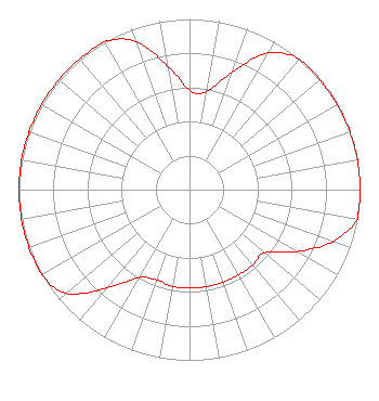 | ||||||||||||||||||
| Azimuth | Ratio | Azimuth | Ratio | Azimuth | Ratio | Azimuth | Ratio | ||||||||||||
| 0 | 0.583 | 10 | 0.583 | 20 | 0.734 | 30 | 0.924 | ||||||||||||
| 40 | 1.000 | 50 | 1.000 | 60 | 1.000 | 70 | 1.000 | ||||||||||||
| 80 | 1.000 | 90 | 1.000 | 100 | 1.000 | 110 | 0.892 | ||||||||||||
| 120 | 0.725 | 130 | 0.576 | 140 | 0.576 | 150 | 0.576 | ||||||||||||
| 160 | 0.576 | 170 | 0.576 | 180 | 0.576 | 190 | 0.576 | ||||||||||||
| 200 | 0.563 | 210 | 0.596 | 220 | 0.751 | 230 | 0.945 | ||||||||||||
| 240 | 1.000 | 250 | 1.000 | 260 | 1.000 | 270 | 1.000 | ||||||||||||
| 280 | 1.000 | 290 | 1.000 | 300 | 1.000 | 310 | 1.000 | ||||||||||||
| 320 | 1.000 | 330 | 1.000 | 340 | 0.924 | 350 | 0.734 | ||||||||||||
Structure Registration Number 1041476 Structure Type: TOWER Registered To: Educational Media Foundation Structure Address: .7 Km Se Of Int I-35 And Us 81 Atascosa, TX County Name: Bexar County ASR Issued: 03/16/2010 Date Built: 10/01/2002 Site Elevation: 216.7 m (711 ft.) Structure Height: 152.4 m (500 ft.) Height Overall: 152.4 m (500 ft.) Overall Height AMSL: 369.1 m (1211 ft.) FAA Determination: 04/30/2001 FAA Study #: 01-ASW-0236-OE FAA Circular #: 70/7460-1K Paint & Light FAA Chapters: 3, 4, 5, 12 Removed expiration date from determination. Scenario 1./jjs/case#635066 29-14-40.0 N 98-44-28.0 W (NAD 83) 29-14-39.1 N 98-44-26.9 W (Converted to NAD 27) |
5700 West Oaks Blvd Rocklin, CA 95765 Phone: 916-251-1600 Not-for-Profit | Date: 10/02/2002 Application Certifier EDUCATIONAL MEDIA FOUNDATION 5700 West Oaks Blvd Rocklin, CA 95765 Applicant SAM WALLINGTON 5700 West Oaks Boulevard Rocklin, CA 95765 DAVID D. OXENFORD Shaw Pittman Llp | |||||||||||||||||