
FCCInfo.com
A Service of Cavell, Mertz & Associates, Inc.
(855) FCC-INFO
|
|
|
|
|
||||||||||||||||
|
|
WWVU-FM Channel: 219A 91.7 MHz Morgantown, West Virginia Service: FM - A full-service FM station or application. Facility ID: 71691 Fac. Service: FM Status: License Application Accepted: 12/10/1993 Application Granted: 04/26/1995 File Number: BLED-19931210KF License Expires: 10/01/1995 Prefix Type: This is a license for a noncommercial educational FM station Application Type: License To Cover FCC Website Links: LMS Facility Details This Application CDBS Application Other WWVU-FM Applications Other WWVU-FM Applications in CDBS Including Superseded Applications Mailing Address Correspondence for WWVU-FM Correspondence related to application BLED-19931210KF Service Contour - Open Street Map or USGS Map (60 dBu) Service Contour - KML / Google Earth (60 dBu) Public Inspection Files Facility Type: NON-COMMERCIAL EDUC. FM Class: A, A Zone I; I-A; or II station; with 0.1kW-6kW ERP and a class contour distance <=28km Site Location: 39-38-09.3 N 79-56-37.2 W (NAD 83) Site Location: 39-38-09.0 N 79-56-38.0 W (Converted to NAD 27) Effective Radiated Power: 2.6 kW Antenna Center HAAT: 55 m (180 ft.) Antenna Center AMSL: 440 m (1444 ft.) Antenna Center HAG: 57 m (187 ft.) Calculated Site Elevation: 383 m. (1257 ft.) Height Overall*: 61 m (200 ft.) (* As Filed In This Application, may differ from ASR Data, Below.) Directional Antenna Antenna Make/Model: Oddball; usually designed by Applicant ODD941227IF Antenna ID: 14721 Polarization: | ||||||||||||||||||
| Antenna Data for Antenna Id: 14721 WWVU-FM FM File: BLED-19931210KF Oddball; usually designed by Applicant - ODD941227IF Service: FM | 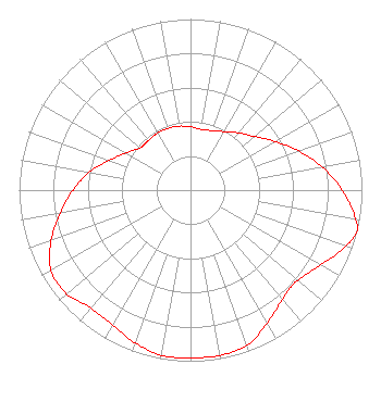 | ||||||||||||||||||
| Azimuth | Ratio | Azimuth | Ratio | Azimuth | Ratio | Azimuth | Ratio | ||||||||||||
| 0 | 0.370 | 10 | 0.360 | 20 | 0.370 | 30 | 0.395 | ||||||||||||
| 40 | 0.435 | 45 | 0.460 | 50 | 0.490 | 60 | 0.570 | ||||||||||||
| 70 | 0.670 | 80 | 0.780 | 90 | 0.885 | 100 | 0.975 | ||||||||||||
| 104 | 1.000 | 110 | 0.960 | 120 | 0.875 | 130 | 0.820 | ||||||||||||
| 135 | 0.815 | 140 | 0.835 | 150 | 0.895 | 160 | 0.965 | ||||||||||||
| 170 | 0.980 | 180 | 0.980 | 190 | 0.980 | 200 | 0.950 | ||||||||||||
| 210 | 0.910 | 220 | 0.900 | 225 | 0.920 | 230 | 0.945 | ||||||||||||
| 240 | 0.940 | 250 | 0.865 | 260 | 0.770 | 270 | 0.685 | ||||||||||||
| 280 | 0.600 | 290 | 0.505 | 300 | 0.435 | 310 | 0.385 | ||||||||||||
| 315 | 0.380 | 320 | 0.380 | 330 | 0.385 | 340 | 0.385 | ||||||||||||
| 350 | 0.380 | ||||||||||||||||||
Structure Registration Number 1233759 [ASR Heights Differ from WWVU-FM Application] Structure Type: TOWER Registered To: West Virginia University Board of Governors Structure Address: 0.2 Kilometers S.e. Willey St. And College Ave., Morgantown, WV County Name: Monongalia County ASR Issued: 05/01/2002 Date Built: 11/17/1993 Site Elevation: 382.5 m (1255 ft.) Structure Height: 60.1 m (197 ft.) Height Overall: 60.6 m (199 ft.) Overall Height AMSL: 443.1 m (1454 ft.) FAA Determination: 10/04/1988 FAA Study #: 88-AEA-0602-OE Paint & Light FAA Chapters: 1, 3, 11, 21 RED LIGHTS/PAINT 39-38-09.0 N 79-56-38.0 W (NAD 83) 39-38-08.7 N 79-56-38.8 W (Converted to NAD 27) |
Mountainlair P.o. Box 6446 Morgantown, WV 26506 Phone: 304-293-3329 Governing Body of West Virginia University | Date: 12/10/1993 Application Certifier WEST VIRGINIA BOARD OF TRUSTEES West Virginia Board Of Trustees Mountainlair, Pob 6446 Morgantown, WV 26506 Applicant | |||||||||||||||||
|
| ||||||||||||||||||