
FCCInfo.com
A Service of Cavell, Mertz & Associates, Inc.
(855) FCC-INFO
|
|
W249DD from 11/26/2013 |
|
|
||||||||||||||||
|
|
W249DD Channel: 249D 97.7 MHz Huntingdon, Pennsylvania Service: FX - A translator or application for a translator. Facility ID: 139876 Fac. Service: FX Programming Delivery Method: Unspecified Status: License Application Accepted: 09/14/2016 Application Granted: 09/21/2016 File Number: BLFT-20160914ABG License Expires: 00/00/0000 Prefix Type: This is a license for a translator Application Type: License To Cover FCC Website Links: LMS Facility Details This Application CDBS Application Other W249DD Applications Other W249DD Applications in CDBS Including Superseded Applications Mailing Address Correspondence for W249DD Correspondence related to application BLFT-20160914ABG Service Contour - Open Street Map or USGS Map (60 dBu) Service Contour - KML / Google Earth (60 dBu) Class: D, A Noncommercial educational operating with no more than 10W Site Location: 40-24-52.3 N 77-54-09.0 W (NAD 83) Site Location: 40-24-52.0 N 77-54-10.0 W (Converted to NAD 27) Effective Radiated Power: 0.108 kW Transmitter Output Power: 0.242 kW Antenna Center HAAT: 0 m Antenna Center AMSL: 722 m (2369 ft.) Antenna Center HAG: 18 m (59 ft.) Site Elevation: 704 m. (2310 ft.) Height Overall*: 58 m (190 ft.) (* As Filed In This Application, may differ from ASR Data, Below.) Directional Antenna Antenna Make/Model: None Antenna ID: 123149 Polarization:
| ||||||||||||||||||
| Antenna Data for Antenna Id: 123149 W249DD FX File: BLFT-20160914ABG None - Service: FX | 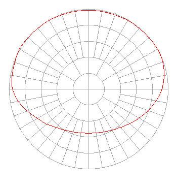 | ||||||||||||||||||
| Azimuth | Ratio | Azimuth | Ratio | Azimuth | Ratio | Azimuth | Ratio | ||||||||||||
| 0 | 0.983 | 10 | 0.983 | 20 | 0.983 | 30 | 0.988 | ||||||||||||
| 40 | 0.988 | 50 | 0.992 | 60 | 1.000 | 70 | 0.991 | ||||||||||||
| 80 | 0.963 | 90 | 0.923 | 100 | 0.862 | 110 | 0.797 | ||||||||||||
| 120 | 0.731 | 130 | 0.676 | 140 | 0.628 | 150 | 0.594 | ||||||||||||
| 160 | 0.571 | 170 | 0.558 | 180 | 0.553 | 190 | 0.558 | ||||||||||||
| 200 | 0.571 | 210 | 0.594 | 220 | 0.628 | 230 | 0.682 | ||||||||||||
| 240 | 0.738 | 250 | 0.815 | 260 | 0.897 | 270 | 0.953 | ||||||||||||
| 280 | 0.973 | 290 | 0.983 | 300 | 1.000 | 310 | 0.992 | ||||||||||||
| 320 | 0.988 | 330 | 0.988 | 340 | 0.983 | 350 | 0.983 | ||||||||||||
Structure Registration Number 1218855 Structure Type: TOWER Registered To: SBA Towers II LLC Structure Address: Top Of Jacks Mtn - Lucy Furnace Road (pa12100-a # 2) Mount Union, PA County Name: Huntingdon County ASR Issued: 01/29/2010 Date Built: 11/30/1979 Site Elevation: 704.4 m (2311 ft.) Structure Height: 54.9 m (180 ft.) Height Overall: 57.9 m (190 ft.) Overall Height AMSL: 762.3 m (2501 ft.) FAA Determination: 01/26/2010 FAA Study #: 2010-AEA-8-OE Paint & Light FAA Chapters: NONE PRIOR STUDY 2007-AEA-2097-OE 40-24-52.7 N 77-54-09.0 W (NAD 83) 40-24-52.4 N 77-54-10.0 W (Converted to NAD 27) |
115 West Main Street Frankfort, KY 40601 Phone: 502-875-1130 Limited Liability Company | Date: 09/14/2016 Application Certifier SOUTHERN BELLE, LLC C/o 115 West Main Street Frankfort, KY 40601 Applicant JOE PORTELLI 609 Benjamin Ct. State College, PA 16803 CONSULTING ENGINEER ALLAN G. MOSKOWITZ, ESQ. Allan G. Moskowitz, Esq. 10845 Tuckahoe Way North Potomac, MD 20878 | |||||||||||||||||