
FCCInfo.com
A Service of Cavell, Mertz & Associates, Inc.
(855) FCC-INFO
|
|
WCNV from 03/18/1998 |
|
|
||||||||||||||||
|
|
WCNV Channel: 206A 89.1 MHz Heathsville, Virginia Service: FM - A full-service FM station or application. Facility ID: 90292 Fac. Service: FM Analog & Digital Status: License Application Accepted: 02/21/2007 Application Granted: 03/07/2007 File Number: BLED-20070221ACN License Expires: 00/00/0000 Prefix Type: This is a license for a noncommercial educational FM station Application Type: License To Cover FCC Website Links: LMS Facility Details This Application CDBS Application Other WCNV Applications Other WCNV Applications in CDBS Including Superseded Applications Mailing Address Correspondence for WCNV Correspondence related to application BLED-20070221ACN Service Contour - Open Street Map or USGS Map (60 dBu) Service Contour - KML / Google Earth (60 dBu) Public Inspection Files Facility Type: NON-COMMERCIAL EDUC. FM Class: A, A Zone I; I-A; or II station; with 0.1kW-6kW ERP and a class contour distance <=28km Site Location: 37-54-22.5 N 76-29-07.8 W (NAD 83) Site Location: 37-54-22.0 N 76-29-09.0 W (Converted to NAD 27) Effective Radiated Power: 0 kW Horiz. ; 3.8 kW Vert. Transmitter Output Power: 1.47 kW Antenna Center HAAT: 0 m Horiz.; 97 m Vert. Antenna Center AMSL: 0 m Horiz.; 114 m Vert. Antenna Center HAG: 0 m Horiz.; 88 m Vert. Site Elevation: 26 m. (85 ft.) Height Overall*: 91 m (299 ft.) (* As Filed In This Application, may differ from ASR Data, Below.) Directional Antenna Antenna Make/Model: DIELECTRIC DCV2ERD, two sections Antenna ID: 75283 Polarization: | ||||||||||||||||||
| Antenna Data for Antenna Id: 75283 WCNV FM File: BLED-20070221ACN DIELECTRIC - DCV2ERD, two sections Service: FM | 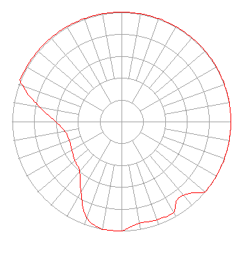 | ||||||||||||||||||
| Azimuth | Ratio | Azimuth | Ratio | Azimuth | Ratio | Azimuth | Ratio | ||||||||||||
| 0 | 1.000 | 10 | 1.000 | 20 | 1.000 | 30 | 1.000 | ||||||||||||
| 40 | 1.000 | 50 | 1.000 | 60 | 1.000 | 70 | 1.000 | ||||||||||||
| 80 | 1.000 | 90 | 1.000 | 100 | 1.000 | 110 | 1.000 | ||||||||||||
| 120 | 1.000 | 130 | 1.000 | 135 | 0.922 | 140 | 0.881 | ||||||||||||
| 145 | 0.881 | 150 | 0.955 | 160 | 0.955 | 170 | 0.944 | ||||||||||||
| 175 | 0.966 | 180 | 1.000 | 190 | 1.000 | 200 | 0.933 | ||||||||||||
| 210 | 0.741 | 220 | 0.596 | 230 | 0.556 | 240 | 0.525 | ||||||||||||
| 250 | 0.507 | 260 | 0.525 | 270 | 0.603 | 280 | 0.759 | ||||||||||||
| 290 | 0.955 | 292 | 1.000 | 300 | 1.000 | 310 | 1.000 | ||||||||||||
| 320 | 1.000 | 330 | 1.000 | 340 | 1.000 | 350 | 1.000 | ||||||||||||
Structure Registration Number 1018226 [ASR Heights Differ from WCNV Application] Structure Type: TOWER Registered To: CENTRAL VIRGINIA EDUCATIONAL TELECOMMUNICATIONS CORP Structure Address: L Side Rt 601 1 Mi S Heathsville, VA County Name: Northumberland County ASR Issued: 08/18/1997 Date Built: 01/01/1971 Site Elevation: 26.5 m (87 ft.) Structure Height: 83.7 m (275 ft.) Height Overall: 90.5 m (297 ft.) Overall Height AMSL: 117 m (384 ft.) FAA Determination: 06/11/1997 FAA Study #: 97-AEA-0902-OE FAA Circular #: 70/7460-1J Paint & Light FAA Chapters: 3, 4, 5, 13 37-54-22.0 N 76-29-08.0 W (NAD 83) 37-54-21.5 N 76-29-09.2 W (Converted to NAD 27) |
23 Sesame Street Richmond, VA 23235 Phone: 804-320-1301 | Date: 02/21/2007 Application Certifier COMMONWEALTH PUBLIC BROADCASTING CORPORATION Central Virginia Educational Television Corporation 23 Sesame Street Richmond, VA 23235 Applicant SAM STRAUS Commonwealth Public Broadcasting Corpora 23 Sesame Street Richmond, VA 23235 TECHNICAL DIRECTOR EVE KLINDERA REED Wiley Rein Llp | |||||||||||||||||