
FCCInfo.com
A Service of Cavell, Mertz & Associates, Inc.
(855) FCC-INFO
|
|
|
|
|
||||||||||||||||
|
|
W298BT Channel: 298D 107.5 MHz Keene, New Hampshire Service: FX - A translator or application for a translator. Facility ID: 140893 Fac. Service: FX Programming Delivery Method: Unspecified Status: License Application Accepted: 11/30/2018 Application Granted: 12/06/2018 File Number: BMLFT-20181130AAR License Expires: 00/00/0000 Prefix Type: This is a modification of license for a translator Application Type: Minor Modification FCC Website Links: LMS Facility Details This Application CDBS Application Other W298BT Applications Other W298BT Applications in CDBS Including Superseded Applications Mailing Address Correspondence for W298BT Correspondence related to application BMLFT-20181130AAR Service Contour - Open Street Map or USGS Map (60 dBu) Service Contour - KML / Google Earth (60 dBu) Class: D, A Noncommercial educational operating with no more than 10W Site Location: 42-55-50.3 N 72-17-58.3 W (NAD 83) Site Location: 42-55-50.0 N 72-17-60.0 W (Converted to NAD 27) Effective Radiated Power: 0.25 kW Transmitter Output Power: 0.289 kW Antenna Center HAAT: -92.6 m Horiz.; 0 m Vert. Antenna Center AMSL: 193 m (633 ft.) Antenna Center HAG: 50 m (164 ft.) Site Elevation: 143 m. (469 ft.) Height Overall*: 55 m (180 ft.) (* As Filed In This Application, may differ from ASR Data, Below.) Directional Antenna Antenna Make/Model: None Antenna ID: 116456 Polarization:
| ||||||||||||||||||
| Antenna Data for Antenna Id: 116456 W298BT FX File: BMLFT-20181130AAR None - Service: FX Pattern and Field Values Include a 340° Clockwise Rotation | 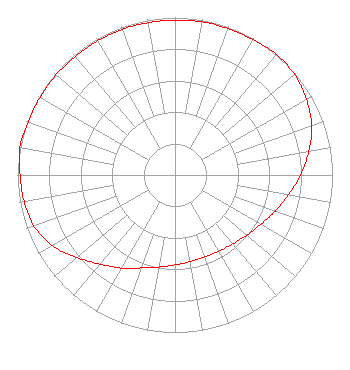 | ||||||||||||||||||
| Azimuth | Ratio | Azimuth | Ratio | Azimuth | Ratio | Azimuth | Ratio | ||||||||||||
| 0 | 0.983 | 10 | 0.988 | 20 | 0.988 | 30 | 0.992 | ||||||||||||
| 40 | 1.000 | 50 | 0.991 | 60 | 0.963 | 70 | 0.923 | ||||||||||||
| 80 | 0.862 | 90 | 0.797 | 100 | 0.731 | 110 | 0.676 | ||||||||||||
| 120 | 0.628 | 130 | 0.594 | 140 | 0.571 | 150 | 0.558 | ||||||||||||
| 160 | 0.553 | 170 | 0.558 | 180 | 0.571 | 190 | 0.594 | ||||||||||||
| 200 | 0.628 | 210 | 0.682 | 220 | 0.738 | 230 | 0.815 | ||||||||||||
| 240 | 0.897 | 250 | 0.953 | 260 | 0.973 | 270 | 0.983 | ||||||||||||
| 280 | 1.000 | 290 | 0.992 | 300 | 0.988 | 310 | 0.988 | ||||||||||||
| 320 | 0.983 | 330 | 0.983 | 340 | 0.983 | 350 | 0.983 | ||||||||||||
Structure Registration Number 1244740 [ASR Heights Differ from W298BT Application] Structure Type: TOWER Registered To: Saga Communications of New Hampshire, LLC Structure Address: 0.23 Mi S-sw Of Intersection West Street And Sr 9 Keene, NH County Name: Cheshire County ASR Issued: 08/11/2004 Date Built: 08/10/2004 Site Elevation: 143.3 m (470 ft.) Structure Height: 53.5 m (176 ft.) Height Overall: 54.5 m (179 ft.) Overall Height AMSL: 197.8 m (649 ft.) FAA Determination: 07/30/2004 FAA Study #: 2004-ANE-673-OE Paint & Light FAA Chapters: NONE 42-55-49.9 N 72-17-58.2 W (NAD 83) 42-55-49.6 N 72-17-59.9 W (Converted to NAD 27) |
73 Kercheval Avenue Grosse Pointe Farms, MI 48236 Phone: 313-886-7070 | Date: 11/30/2018 Application Certifier SAGA COMMUNICATIONS OF NEW ENGLAND, LLC 73 Kercheval Avenue Grosse Pointe Farms, MI 48236 Applicant JUSTIN ASHER Asher Broadcast Consulting, Llc 579 Babcock Road Bronson, MI 49028-9347 TECHNICAL CONSULTANT GARY S. SMITHWICK, ESQ. Smithwick & Belendiuk, P.c. 5028 Wisconsin Avenue, Nw Suite 301 Washington, DC 20016 | |||||||||||||||||