
FCCInfo.com
A Service of Cavell, Mertz & Associates, Inc.
(855) FCC-INFO
|
|
WJZE from 04/19/1991 WJZE from 08/31/1989 |
|  |
|
|||||||||||||||
|
|
WJZE Channel: 247A 97.3 MHz Oak Harbor, Ohio Service: FM - A full-service FM station or application. Facility ID: 55183 Fac. Service: FM Status: License 73.215 Station Application Accepted: 12/07/2006 Application Granted: 01/17/2007 File Number: BLH-20061207AAU License Expires: 00/00/0000 Prefix Type: This is a license for a commercial FM station Application Type: Amendment FCC Website Links: LMS Facility Details This Application CDBS Application Other WJZE Applications Other WJZE Applications in CDBS Including Superseded Applications Mailing Address Correspondence for WJZE Correspondence related to application BLH-20061207AAU Service Contour - Open Street Map or USGS Map (60 dBu) Service Contour - KML / Google Earth (60 dBu) Public Inspection Files Facility Type: FM STATION Class: A, A Zone I; I-A; or II station; with 0.1kW-6kW ERP and a class contour distance <=28km Site Location: 41-28-19.2 N 83-25-04.7 W (NAD 83) Site Location: 41-28-19.0 N 83-25-05.0 W (Converted to NAD 27) Effective Radiated Power: 4.3 kW Transmitter Output Power: 4.499 kW Antenna Center HAAT: 118.1 m (387 ft.) Antenna Center AMSL: 307.4 m (1009 ft.) Antenna Center HAG: 115.4 m (379 ft.) Calculated Site Elevation: 192 m. (630 ft.) Height Overall*: 130.8 m (429 ft.) (* As Filed In This Application, may differ from ASR Data, Below.) Directional Antenna Antenna Make/Model: Electronics Research Inc. LP-2E-DA-HW,two sections, 0.5 wavelength spacing Antenna ID: 76576 Polarization: | ||||||||||||||||||
| Antenna Data for Antenna Id: 76576 WJZE FM File: BLH-20061207AAU Electronics Research Inc. - LP-2E-DA-HW,two sections, 0.5 wavelength spacing Service: FM | 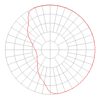 | ||||||||||||||||||
| Azimuth | Ratio | Azimuth | Ratio | Azimuth | Ratio | Azimuth | Ratio | ||||||||||||
| 0 | 1.000 | 10 | 1.000 | 20 | 1.000 | 30 | 1.000 | ||||||||||||
| 40 | 1.000 | 45 | 1.000 | 50 | 1.000 | 60 | 1.000 | ||||||||||||
| 70 | 1.000 | 80 | 1.000 | 90 | 1.000 | 100 | 1.000 | ||||||||||||
| 110 | 1.000 | 120 | 1.000 | 130 | 1.000 | 135 | 1.000 | ||||||||||||
| 140 | 1.000 | 150 | 1.000 | 160 | 1.000 | 170 | 1.000 | ||||||||||||
| 180 | 0.940 | 190 | 0.750 | 200 | 0.650 | 210 | 0.540 | ||||||||||||
| 220 | 0.430 | 225 | 0.400 | 230 | 0.370 | 240 | 0.330 | ||||||||||||
| 250 | 0.310 | 260 | 0.310 | 270 | 0.330 | 280 | 0.370 | ||||||||||||
| 290 | 0.430 | 300 | 0.540 | 310 | 0.650 | 315 | 0.700 | ||||||||||||
| 320 | 0.750 | 330 | 0.940 | 340 | 1.000 | 350 | 1.000 | ||||||||||||
Structure Registration Number 1015474 Structure Type: TOWER Registered To: Urban Radio Real Estate, LLC Structure Address: 1201 Fremont Pike Woodville, OH County Name: Wood County ASR Issued: 03/20/2019 Date Built: 03/01/1991 Site Elevation: 192 m (630 ft.) Structure Height: 130 m (427 ft.) Height Overall: 130.8 m (429 ft.) Overall Height AMSL: 322.8 m (1059 ft.) FAA Determination: 01/06/1990 FAA Study #: 89-AGL-1681-OE FAA Circular #: 70/7460-1G Paint & Light FAA Chapters: 3, 4, 5, 9 41-28-19.0 N 83-25-05.0 W (NAD 83) 41-28-18.8 N 83-25-05.3 W (Converted to NAD 27) |
C/o Glass City Multimedia, Llc 100 Se 2nd St., Ste 2000 Miami, FL 33131 Phone: 786-787-0404 Limited Liability Company | Date: 12/07/2006 Application Certifier URBAN RADIO LICENSES, LLC 273 Azalea Road Suite 1-308 Mobile, AL 36609 Applicant JEFFERSON G. BROCK Graham Brock, Inc. P. O. Box 24466 St. Simons Island, GA 31522-7466 TECHNICAL CONSULTANT HOWARD M. WEISS, ESQUIRE Fletcher, Heald & Hildreth, P.l.c. | |||||||||||||||||
| |||||||||||||||||||