
FCCInfo.com
A Service of Cavell, Mertz & Associates, Inc.
(855) FCC-INFO
|
|
|
|
|
||||||||||||||||
|
|
W263BG Channel: 263D 100.5 MHz Owensboro, Kentucky Service: FX - A translator or application for a translator. Facility ID: 138372 Fac. Service: FX Programming Delivery Method: Unspecified Status: License Application Accepted: 10/31/2005 Application Granted: 02/01/2006 File Number: BLFT-20051031ADC License Expires: 00/00/0000 Prefix Type: This is a license for a translator Application Type: License To Cover FCC Website Links: LMS Facility Details This Application CDBS Application Other W263BG Applications Other W263BG Applications in CDBS Including Superseded Applications Mailing Address Correspondence for W263BG Correspondence related to application BLFT-20051031ADC Service Contour - Open Street Map or USGS Map (60 dBu) Service Contour - KML / Google Earth (60 dBu) Class: D, A Noncommercial educational operating with no more than 10W Site Location: 37-46-32.2 N 87-09-31.0 W (NAD 83) Site Location: 37-46-32.0 N 87-09-31.0 W (Converted to NAD 27) Effective Radiated Power: 0.25 kW Transmitter Output Power: 0.1 kW Antenna Center HAAT: 116.9 m Horiz.; 0 m Vert. Antenna Center AMSL: 237 m (778 ft.) Antenna Center HAG: 115 m (377 ft.) Site Elevation: 122 m. (400 ft.) Height Overall*: 123 m (404 ft.) (* As Filed In This Application, may differ from ASR Data, Below.) Directional Antenna Antenna Make/Model: None Antenna ID: 69218 Polarization:
| ||||||||||||||||||
| Antenna Data for Antenna Id: 69218 W263BG FX File: BLFT-20051031ADC None - Service: FX | 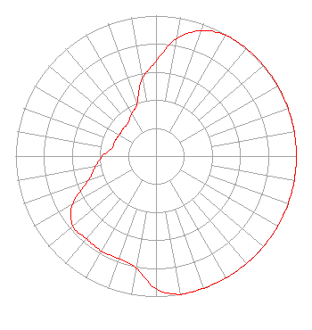 | ||||||||||||||||||
| Azimuth | Ratio | Azimuth | Ratio | Azimuth | Ratio | Azimuth | Ratio | ||||||||||||
| 0 | 0.675 | 10 | 0.850 | 20 | 0.950 | 30 | 0.993 | ||||||||||||
| 40 | 1.000 | 50 | 1.000 | 60 | 1.000 | 70 | 1.000 | ||||||||||||
| 80 | 1.000 | 90 | 1.000 | 100 | 1.000 | 110 | 1.000 | ||||||||||||
| 120 | 1.000 | 130 | 1.000 | 140 | 1.000 | 150 | 1.000 | ||||||||||||
| 160 | 1.000 | 170 | 1.000 | 180 | 0.944 | 190 | 0.807 | ||||||||||||
| 200 | 0.777 | 210 | 0.779 | 220 | 0.770 | 230 | 0.773 | ||||||||||||
| 240 | 0.688 | 250 | 0.515 | 260 | 0.439 | 270 | 0.382 | ||||||||||||
| 280 | 0.319 | 290 | 0.311 | 300 | 0.302 | 310 | 0.304 | ||||||||||||
| 320 | 0.309 | 330 | 0.348 | 340 | 0.397 | 350 | 0.558 | ||||||||||||
Structure Registration Number 1044742 Structure Type: LTOWER Registered To: Spectrum Mid-America, LLC Structure Address: 100 Industrial Drive - Tower 2 Owensboro, KY County Name: Daviess County ASR Issued: 06/08/2021 Date Built: 11/01/2007 Site Elevation: 121.9 m (400 ft.) Structure Height: 121.9 m (400 ft.) Height Overall: 123.4 m (405 ft.) Overall Height AMSL: 245.3 m (805 ft.) FAA Determination: 04/28/2021 FAA Study #: 2021-ASO-13577-OE FAA Circular #: 70/7460-1M Paint & Light FAA Chapters: 3, 4, 5, 15 PRIOR STUDY 2007-ASO-541-OE 37-46-30.4 N 87-09-32.2 W (NAD 83) 37-46-30.2 N 87-09-32.2 W (Converted to NAD 27) |
Nashville, TN 37215 Phone: 615-361-7560 Corporation | Date: 10/31/2005 Application Certifier THE CROMWELL GROUP, INC. OF KENTUCKY P.o. Box 150846 Nashville, TN 37215-0846 Applicant EDWARD L. THOMAS 4650 Rome Parkway Owensboro, KY 42301 TECHNICAL CONSULTANT JOHN F. GARZIGLIA, ESQ. Womble Carlyle Sandridge & Rice, Pllc 1401 Eye Street, N.w. Seventh Floor Washington, DC 20005 | |||||||||||||||||