
FCCInfo.com
A Service of Cavell, Mertz & Associates, Inc.
(855) FCC-INFO
|
|
W295BT from 03/10/2004 |
|
|
||||||||||||||||
|
|
W295BT Channel: 295D 106.9 MHz Connersville, Indiana Service: FX - A translator or application for a translator. Facility ID: 138099 Fac. Service: FX Programming Delivery Method: Unspecified Status: License Application Accepted: 06/03/2016 Application Granted: 06/20/2016 File Number: BLFT-20160603ABM License Expires: 00/00/0000 Prefix Type: This is a license for a translator Application Type: License To Cover FCC Website Links: LMS Facility Details This Application CDBS Application Other W295BT Applications Other W295BT Applications in CDBS Including Superseded Applications Mailing Address Correspondence for W295BT Correspondence related to application BLFT-20160603ABM Service Contour - Open Street Map or USGS Map (60 dBu) Service Contour - KML / Google Earth (60 dBu) Class: D, A Noncommercial educational operating with no more than 10W Site Location: 39-38-15.2 N 85-08-44.9 W (NAD 83) Site Location: 39-38-15.0 N 85-08-45.0 W (Converted to NAD 27) Effective Radiated Power: 0.25 kW Transmitter Output Power: 0.63 kW Antenna Center HAAT: 0 m Antenna Center AMSL: 365 m (1198 ft.) Antenna Center HAG: 60 m (197 ft.) Site Elevation: 305 m. (1001 ft.) Height Overall*: 61 m (200 ft.) (* As Filed In This Application, may differ from ASR Data, Below.) Directional Antenna Antenna Make/Model: None Antenna ID: 124501 Polarization:
| ||||||||||||||||||
| Antenna Data for Antenna Id: 124501 W295BT FX File: BLFT-20160603ABM None - Service: FX | 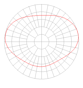 | ||||||||||||||||||
| Azimuth | Ratio | Azimuth | Ratio | Azimuth | Ratio | Azimuth | Ratio | ||||||||||||
| 0 | 0.701 | 10 | 0.715 | 20 | 0.747 | 30 | 0.794 | ||||||||||||
| 40 | 0.851 | 50 | 0.909 | 60 | 0.959 | 70 | 0.993 | ||||||||||||
| 80 | 1.000 | 90 | 0.974 | 100 | 0.916 | 110 | 0.837 | ||||||||||||
| 120 | 0.763 | 130 | 0.708 | 140 | 0.674 | 150 | 0.660 | ||||||||||||
| 160 | 0.659 | 170 | 0.664 | 180 | 0.670 | 190 | 0.670 | ||||||||||||
| 200 | 0.675 | 210 | 0.681 | 220 | 0.696 | 230 | 0.728 | ||||||||||||
| 240 | 0.779 | 250 | 0.845 | 260 | 0.915 | 270 | 0.964 | ||||||||||||
| 280 | 0.982 | 290 | 0.971 | 300 | 0.934 | 310 | 0.882 | ||||||||||||
| 320 | 0.824 | 330 | 0.771 | 340 | 0.729 | 350 | 0.706 | ||||||||||||
Structure Registration Number 1028395 Structure Type: GTOWER Registered To: RODGERS BROADCASTING CORPORATION Structure Address: 100 Summit Ave Connersville, IN County Name: Fayette County ASR Issued: 09/11/2014 Date Built: 02/11/2015 Site Elevation: 305 m (1001 ft.) Structure Height: 60.6 m (199 ft.) Height Overall: 60.6 m (199 ft.) Overall Height AMSL: 365.6 m (1199 ft.) FAA Determination: 08/27/2014 FAA Study #: 2014-AGL-8586-OE Paint & Light FAA Chapters: NONE PRIOR STUDY 1993-AGL-2090-OE 39-38-15.0 N 85-08-45.0 W (NAD 83) 39-38-14.8 N 85-08-45.1 W (Converted to NAD 27) |
2301 West Main Street Richmond, IN 47374-1646 Phone: 765-962-6533 | Date: 06/03/2016 Application Certifier RODGERS BROADCASTING CORPORATION 2301 W. Main Street Richmond, IN 47374 Applicant R. STUART GRAHAM Graham Brock, Inc. P. O. Box 24466 St. Simons Island, GA 31522-7466 TECHNICAL CONSULTANT CARY S. TEPPER Tepper Law Firm, Llc 4900 Auburn Street Suite 100 Bethesda, MD 20814-2632 | |||||||||||||||||