
FCCInfo.com
A Service of Cavell, Mertz & Associates, Inc.
(855) FCC-INFO
|
|
WXVS from 07/29/1985 WXVS from 10/31/1984 |
|
|
||||||||||||||||
|
|
WXVS Channel: 211C1 90.1 MHz Waycross, Georgia Service: FM - A full-service FM station or application. Facility ID: 23923 Fac. Service: FM Analog & Digital Status: License Application Accepted: 01/31/2008 Application Granted: 03/04/2008 File Number: BMLED-20080131AJH License Expires: 00/00/0000 Prefix Type: This is a modification of license for a noncommercial educational FM station Application Type: Minor Modification FCC Website Links: LMS Facility Details This Application CDBS Application Other WXVS Applications Other WXVS Applications in CDBS Including Superseded Applications Mailing Address Correspondence for WXVS Correspondence related to application BMLED-20080131AJH Service Contour - Open Street Map or USGS Map (60 dBu) Service Contour - KML / Google Earth (60 dBu) Public Inspection Files Facility Type: NON-COMMERCIAL EDUC. FM Class: C1, A Zone II station; with 50kW-100kW ERP and a class contour distance 52km-72km Site Location: 31-13-17.8 N 82-34-23.5 W (NAD 83) Site Location: 31-13-17.0 N 82-34-24.0 W (Converted to NAD 27) Effective Radiated Power: 79 kW Horiz. ; 77.6 kW Vert. Transmitter Output Power: 16.6 kW Antenna Center HAAT: 280 m (919 ft.) Antenna Center AMSL: 329 m (1079 ft.) Antenna Center HAG: 280 m (919 ft.) Calculated Site Elevation: 49 m. (161 ft.) Height Overall*: 332 m (1089 ft.) (* As Filed In This Application, may differ from ASR Data, Below.) Directional Antenna Antenna Make/Model: Jampro JSCP-6D-DA, six sections Antenna ID: 13693 Polarization: | ||||||||||||||||||
| Antenna Data for Antenna Id: 13693 WXVS FM File: BMLED-20080131AJH Jampro - JSCP-6D-DA, six sections Service: FM | 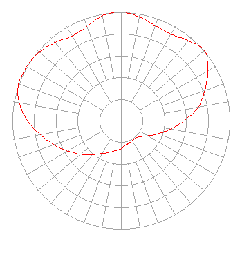 | ||||||||||||||||||
| Azimuth | Ratio | Azimuth | Ratio | Azimuth | Ratio | Azimuth | Ratio | ||||||||||||
| 0 | 1.000 | 10 | 0.970 | 20 | 0.930 | 30 | 0.920 | ||||||||||||
| 40 | 0.960 | 50 | 1.000 | 60 | 0.920 | 70 | 0.820 | ||||||||||||
| 80 | 0.720 | 90 | 0.580 | 100 | 0.460 | 110 | 0.360 | ||||||||||||
| 120 | 0.280 | 130 | 0.230 | 140 | 0.210 | 150 | 0.210 | ||||||||||||
| 160 | 0.220 | 170 | 0.230 | 180 | 0.260 | 190 | 0.280 | ||||||||||||
| 200 | 0.310 | 210 | 0.350 | 220 | 0.410 | 230 | 0.480 | ||||||||||||
| 240 | 0.560 | 250 | 0.650 | 260 | 0.750 | 270 | 0.860 | ||||||||||||
| 280 | 0.950 | 290 | 1.000 | 300 | 1.000 | 310 | 0.980 | ||||||||||||
| 320 | 0.940 | 330 | 0.900 | 340 | 0.920 | 350 | 0.980 | ||||||||||||
Structure Registration Number 1018780 [ASR Heights Differ from WXVS Application] Structure Type: GTOWER Registered To: Georgia Public Telecommunications Commission Structure Address: 6433 Tv Tower Rd. (3.1 Miles Se Of Fairfax, Ga). Fairfax, GA County Name: Ware County ASR Issued: 01/05/2024 Date Built: 03/08/2016 Site Elevation: 52.1 m (171 ft.) Structure Height: 331.9 m (1089 ft.) Height Overall: 331.9 m (1089 ft.) Overall Height AMSL: 384 m (1260 ft.) FAA Determination: 10/24/2023 FAA Study #: 2023-ASO-29631-OE FAA Circular #: 70/7460-1M Paint & Light FAA Chapters: 4, 9, 15 PRIOR STUDY 2015-ASO-7317-OE 31-13-22.8 N 82-34-40.5 W (NAD 83) 31-13-22.0 N 82-34-41.0 W (Converted to NAD 27) |
260 14th St Nw Atlanta, GA 30318-5360 Phone: 404-685-2410 Government Entity | Date: 01/31/2008 Application Certifier GEORGIA PUBLIC TELECOMMUNICATIONS COMMISSION 260 Fourteenth Street, N.w. Atlanta, GA 30318 Applicant WILLIAM T. GODFREY, JR. Kessler And Gehman Associates, Inc. 507 Nw 60th Street, Suite C Gainesville, FL 32606-2702 CONSULTING ENGINEER THEODORE D. FRANK Arnold & Porter Llp | |||||||||||||||||