
FCCInfo.com
A Service of Cavell, Mertz & Associates, Inc.
(855) FCC-INFO
|
|
|
|
|
||||||||||||||||
|
|
KOYR Channel: 203C3 88.5 MHz Yorktown, Arkansas Service: FM - A full-service FM station or application. Facility ID: 176803 Fac. Service: FM Status: License Application Accepted: 03/11/2013 Application Granted: 04/02/2013 File Number: BLED-20130311AEP License Expires: 00/00/0000 Prefix Type: This is a license for a noncommercial educational FM station Application Type: Amendment FCC Website Links: LMS Facility Details This Application CDBS Application Other KOYR Applications Other KOYR Applications in CDBS Including Superseded Applications Mailing Address Correspondence for KOYR Correspondence related to application BLED-20130311AEP Service Contour - Open Street Map or USGS Map (60 dBu) Service Contour - KML / Google Earth (60 dBu) Public Inspection Files Facility Type: NON-COMMERCIAL EDUC. FM Class: C3, A Zone II station; with 6kW-25kW ERP and a class contour distance 28km-39km Site Location: 33-43-49.4 N 91-48-56.5 W (NAD 83) Site Location: 33-43-49.0 N 91-48-56.0 W (Converted to NAD 27) Effective Radiated Power: 4.5 kW Transmitter Output Power: 1 kW Antenna Center HAAT: 190 m (623 ft.) Antenna Center AMSL: 260 m (853 ft.) Antenna Center HAG: 145.7 m (478 ft.) Calculated Site Elevation: 114.3 m. (375 ft.) Height Overall*: 152 m (499 ft.) (* As Filed In This Application, may differ from ASR Data, Below.) Directional Antenna Antenna Make/Model: ETC FM-4CP-DA, four sections, 0.75 wavelength spaced Antenna ID: 13375 Polarization: | ||||||||||||||||||
| Antenna Data for Antenna Id: 13375 KOYR FM File: BLED-20130311AEP ETC - FM-4CP-DA, four sections, 0.75 wavelength spaced Service: FM | 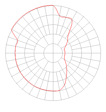 | ||||||||||||||||||
| Azimuth | Ratio | Azimuth | Ratio | Azimuth | Ratio | Azimuth | Ratio | ||||||||||||
| 0 | 1.000 | 10 | 0.794 | 20 | 0.794 | 30 | 0.794 | ||||||||||||
| 40 | 0.501 | 50 | 0.398 | 60 | 0.315 | 70 | 0.251 | ||||||||||||
| 80 | 0.251 | 90 | 0.251 | 100 | 0.251 | 110 | 0.251 | ||||||||||||
| 120 | 0.282 | 130 | 0.355 | 140 | 0.447 | 150 | 0.562 | ||||||||||||
| 160 | 0.708 | 170 | 0.794 | 180 | 0.794 | 190 | 0.794 | ||||||||||||
| 200 | 0.794 | 210 | 0.794 | 220 | 0.794 | 230 | 0.794 | ||||||||||||
| 240 | 0.794 | 250 | 0.794 | 260 | 0.794 | 270 | 0.794 | ||||||||||||
| 280 | 0.794 | 290 | 0.794 | 300 | 1.000 | 310 | 1.000 | ||||||||||||
| 320 | 1.000 | 330 | 1.000 | 340 | 1.000 | 350 | 1.000 | ||||||||||||
Structure Registration Number 1062917 Structure Type: TOWER Registered To: Pine Broadcasting, Inc. Structure Address: 7.3 Km Southeast Plantersville, AR County Name: Drew County ASR Issued: 03/19/2014 Date Built: 04/01/1997 Site Elevation: 114.3 m (375 ft.) Structure Height: 151 m (495 ft.) Height Overall: 152 m (499 ft.) Overall Height AMSL: 266.3 m (874 ft.) FAA Determination: 12/06/1995 FAA Study #: 95-ASW-2260-OE FAA Circular #: 70/7460-1H Paint & Light FAA Chapters: 3, 4, 5, 13 33-43-49.0 N 91-48-56.0 W (NAD 83) 33-43-48.6 N 91-48-55.5 W (Converted to NAD 27) |
3302 N. Van Dyke Rd. Imlay City, MI 48444 Phone: 810-724-2638 Not-for-Profit | Date: 03/11/2013 Application Certifier SMILE FM 3302 N. Van Dyke Imlay City, MI 48444 Applicant EDWARD CZELADA 3302 N. Van Dyke Rd Imlay City, MI 48444 PRESIDENT EDWARD CZELADA Smile Fm | |||||||||||||||||