
FCCInfo.com
A Service of Cavell, Mertz & Associates, Inc.
(855) FCC-INFO
|
|
K266CJ from 12/22/2016 K266CJ from 12/03/2013 |
|
|
||||||||||||||||
|
|
K266CJ Channel: 266D 101.1 MHz Everett, Washington Service: FX - A translator or application for a translator. Facility ID: 156877 Fac. Service: FX Programming Delivery Method: Unspecified Status: License Application Accepted: 03/13/2017 Application Granted: 03/22/2017 File Number: BMLFT-20170313ABN License Expires: 00/00/0000 Prefix Type: This is a modification of license for a translator Application Type: Minor Modification FCC Website Links: LMS Facility Details This Application CDBS Application Other K266CJ Applications Other K266CJ Applications in CDBS Including Superseded Applications Mailing Address Correspondence for K266CJ Correspondence related to application BMLFT-20170313ABN Service Contour - Open Street Map or USGS Map (60 dBu) Service Contour - KML / Google Earth (60 dBu) Class: D, A Noncommercial educational operating with no more than 10W Site Location: 47-55-46.3 N 122-14-56.5 W (NAD 83) Site Location: 47-55-47.0 N 122-14-52.0 W (Converted to NAD 27) Effective Radiated Power: 0.25 kW Transmitter Output Power: 0.351 kW Antenna Center HAAT: 0 m Antenna Center AMSL: 209 m (686 ft.) Antenna Center HAG: 57 m (187 ft.) Site Elevation: 152 m. (499 ft.) Height Overall*: 76 m (249 ft.) (* As Filed In This Application, may differ from ASR Data, Below.) Directional Antenna Antenna Make/Model: None Antenna ID: 125210 Polarization:
| ||||||||||||||||||
| Antenna Data for Antenna Id: 125210 K266CJ FX File: BMLFT-20170313ABN None - Service: FX | 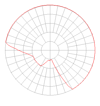 | ||||||||||||||||||
| Azimuth | Ratio | Azimuth | Ratio | Azimuth | Ratio | Azimuth | Ratio | ||||||||||||
| 0 | 1.000 | 10 | 1.000 | 20 | 1.000 | 30 | 1.000 | ||||||||||||
| 40 | 1.000 | 50 | 1.000 | 60 | 1.000 | 70 | 1.000 | ||||||||||||
| 80 | 1.000 | 90 | 1.000 | 100 | 1.000 | 110 | 1.000 | ||||||||||||
| 120 | 1.000 | 130 | 1.000 | 140 | 1.000 | 150 | 1.000 | ||||||||||||
| 160 | 0.500 | 170 | 0.230 | 180 | 0.230 | 190 | 0.230 | ||||||||||||
| 200 | 0.300 | 210 | 0.400 | 220 | 0.400 | 230 | 0.400 | ||||||||||||
| 240 | 0.400 | 250 | 0.400 | 260 | 0.500 | 270 | 0.700 | ||||||||||||
| 280 | 1.000 | 290 | 1.000 | 300 | 1.000 | 310 | 1.000 | ||||||||||||
| 320 | 1.000 | 330 | 1.000 | 340 | 1.000 | 350 | 1.000 | ||||||||||||
Structure Registration Number 1239952 Structure Type: TOWER Registered To: JACOTOWER, INC. Structure Address: Nw Corner Of Hardeson Rd. And 75th St. Sw Everett, WA County Name: Snohomish County ASR Issued: 08/15/2003 Date Built: 06/30/2007 Site Elevation: 152.4 m (500 ft.) Structure Height: 76.2 m (250 ft.) Height Overall: 76.2 m (250 ft.) Overall Height AMSL: 228.6 m (750 ft.) FAA Determination: 01/03/2003 FAA Study #: 2002-ANM-2136-OE FAA Circular #: 70/7460-1K Paint & Light FAA Chapters: 3, 4, 5, 12 47-55-46.2 N 122-14-56.5 W (NAD 83) 47-55-46.9 N 122-14-52.0 W (Converted to NAD 27) |
2707 Colby Avenue, Suite 1380 Everett, WA 98201 Phone: 425-304-1381 Limited Liability Company | Date: 03/13/2017 Application Certifier CAAM PARTNERSHIP LLC P.o. Box 5267 Everett, WA 98206-5267 Applicant MARK LIPP Wiley Rein Llp 1776 K Street Nw Washington, DC 20006 CHARLES M. ANDERSON Anderson Communications, Llc 1519 Euclid Avenue Bowling Green, KY 42103 CONSULTING ENGINEER | |||||||||||||||||