
FCCInfo.com
A Service of Cavell, Mertz & Associates, Inc.
(855) FCC-INFO
|
|
|
|
|
||||||||||||||||
|
|
KJCC Channel: 208C2 89.5 MHz Carnegie, Oklahoma Service: FM - A full-service FM station or application. Facility ID: 122517 Fac. Service: FM Status: License Application Accepted: 02/27/2017 Application Granted: 03/24/2017 File Number: BLED-20170227AAD License Expires: 00/00/0000 Prefix Type: This is a license for a noncommercial educational FM station Application Type: License To Cover FCC Website Links: LMS Facility Details This Application CDBS Application Other KJCC Applications Other KJCC Applications in CDBS Including Superseded Applications Mailing Address Correspondence for KJCC Correspondence related to application BLED-20170227AAD Service Contour - Open Street Map or USGS Map (60 dBu) Service Contour - KML / Google Earth (60 dBu) Public Inspection Files Facility Type: NON-COMMERCIAL EDUC. FM Class: C2, A Zone II station; with 25kW-50kW ERP and a class contour distance 39km-52km Site Location: 35-21-17.2 N 98-13-59.2 W (NAD 83) Site Location: 35-21-17.0 N 98-13-58.0 W (Converted to NAD 27) Effective Radiated Power: 23.5 kW Transmitter Output Power: 8.002 kW Antenna Center HAAT: 118.8 m (390 ft.) Antenna Center AMSL: 562 m (1844 ft.) Antenna Center HAG: 64 m (210 ft.) Site Elevation: 498 m. (1634 ft.) Height Overall*: 106.4 m (349 ft.) (* As Filed In This Application, may differ from ASR Data, Below.) Directional Antenna Antenna Make/Model: Propagation System Inc PSIFMR-4C-R-DA, four sections Antenna ID: 124704 Polarization:
| ||||||||||||||||||
| Antenna Data for Antenna Id: 124704 KJCC FM File: BLED-20170227AAD Propagation System Inc - PSIFMR-4C-R-DA, four sections Service: FM | 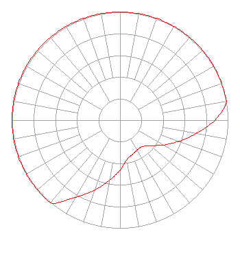 | ||||||||||||||||||
| Azimuth | Ratio | Azimuth | Ratio | Azimuth | Ratio | Azimuth | Ratio | ||||||||||||
| 0 | 1.000 | 10 | 1.000 | 20 | 1.000 | 30 | 1.000 | ||||||||||||
| 40 | 1.000 | 50 | 1.000 | 60 | 1.000 | 70 | 1.000 | ||||||||||||
| 80 | 1.000 | 90 | 0.879 | 100 | 0.715 | 110 | 0.577 | ||||||||||||
| 120 | 0.461 | 130 | 0.367 | 140 | 0.320 | 150 | 0.318 | ||||||||||||
| 160 | 0.338 | 170 | 0.370 | 180 | 0.466 | 190 | 0.566 | ||||||||||||
| 200 | 0.691 | 210 | 0.823 | 220 | 1.000 | 230 | 1.000 | ||||||||||||
| 240 | 1.000 | 250 | 1.000 | 260 | 1.000 | 270 | 1.000 | ||||||||||||
| 280 | 1.000 | 290 | 1.000 | 300 | 1.000 | 310 | 1.000 | ||||||||||||
| 320 | 1.000 | 330 | 1.000 | 340 | 1.000 | 350 | 1.000 | ||||||||||||
Structure Registration Number 1272122 Structure Type: TOWER Registered To: SBA Monarch Towers I, LLC Structure Address: 14090 County Street 2670 (ok01730c) Hinton, OK County Name: Caddo County ASR Issued: 03/20/2020 Date Built: 11/23/2009 Site Elevation: 498.3 m (1635 ft.) Structure Height: 106.4 m (349 ft.) Height Overall: 106.4 m (349 ft.) Overall Height AMSL: 604.7 m (1984 ft.) FAA Determination: 07/24/2009 FAA Study #: 2009-ASW-3152-OE FAA Circular #: 70/7460-1K Paint & Light FAA Chapters: 4, 8, 12 Removed expiration date from determination. Scenario 1./jjs/case#635066 35-21-17.5 N 98-13-59.5 W (NAD 83) 35-21-17.3 N 98-13-58.3 W (Converted to NAD 27) |
4002 N. 3300 E. Twin Falls, ID 83303 Phone: 208-733-3133 Not-for-Profit | Date: 02/27/2017 Application Certifier CALVARY CHAPEL OF TWIN FALLS, INC. Po Box 391 Twin Falls, ID 83303 Applicant LOIS MILLS P.o. Box 391 Twin Falls, ID 83303 APPLICATION TECHNICIAN CARY TEPPER Tepper Law Firm, Llc | |||||||||||||||||