
FCCInfo.com
A Service of Cavell, Mertz & Associates, Inc.
(855) FCC-INFO
|
|
WVMU from 07/06/2009 |
|  |
|
|||||||||||||||
|
|
WVMU Channel: 219A 91.7 MHz Ashtabula, Ohio Service: FM - A full-service FM station or application. Facility ID: 172330 Fac. Service: FM Status: License Application Accepted: 06/12/2012 Application Granted: 10/18/2012 File Number: BLED-20120612ABQ License Expires: 00/00/0000 Prefix Type: This is a license for a noncommercial educational FM station Application Type: License To Cover FCC Website Links: LMS Facility Details This Application CDBS Application Other WVMU Applications Other WVMU Applications in CDBS Including Superseded Applications Mailing Address Correspondence for WVMU Correspondence related to application BLED-20120612ABQ Service Contour - Open Street Map or USGS Map (60 dBu) Service Contour - KML / Google Earth (60 dBu) Public Inspection Files Facility Type: NON-COMMERCIAL EDUC. FM Class: A, A Zone I; I-A; or II station; with 0.1kW-6kW ERP and a class contour distance <=28km Site Location: 41-51-14.0 N 80-41-20.0 W (NAD 83) Site Location: 41-51-13.8 N 80-41-20.7 W (Converted to NAD 27) Effective Radiated Power: 3.2 kW Transmitter Output Power: 2.6 kW Antenna Center HAAT: 104.3 m (342 ft.) Antenna Center AMSL: 344.2 m (1129 ft.) Antenna Center HAG: 67.1 m (220 ft.) Calculated Site Elevation: 277.1 m. (909 ft.) Height Overall*: 70.1 m (230 ft.) (* As Filed In This Application, may differ from ASR Data, Below.) Directional Antenna Antenna Make/Model: Systems With Reliability Inc. FMEC/2-PLUS-HWS-DA 2 bay.5 wavelength spaced Antenna ID: 109072 Polarization:
| ||||||||||||||||||
| Antenna Data for Antenna Id: 109072 WVMU FM File: BLED-20120612ABQ Systems With Reliability Inc. - FMEC/2-PLUS-HWS-DA 2 bay.5 wavelength spaced Service: FM | 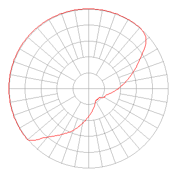 | ||||||||||||||||||
| Azimuth | Ratio | Azimuth | Ratio | Azimuth | Ratio | Azimuth | Ratio | ||||||||||||
| 0 | 1.000 | 10 | 1.000 | 20 | 1.000 | 30 | 1.000 | ||||||||||||
| 40 | 1.000 | 50 | 0.944 | 60 | 0.750 | 70 | 0.596 | ||||||||||||
| 80 | 0.474 | 90 | 0.377 | 100 | 0.300 | 110 | 0.239 | ||||||||||||
| 120 | 0.224 | 130 | 0.179 | 140 | 0.178 | 150 | 0.179 | ||||||||||||
| 160 | 0.225 | 170 | 0.283 | 180 | 0.356 | 190 | 0.448 | ||||||||||||
| 200 | 0.563 | 210 | 0.665 | 220 | 0.800 | 230 | 1.000 | ||||||||||||
| 240 | 1.000 | 250 | 1.000 | 260 | 1.000 | 270 | 1.000 | ||||||||||||
| 280 | 1.000 | 290 | 1.000 | 300 | 1.000 | 310 | 1.000 | ||||||||||||
| 320 | 1.000 | 330 | 1.000 | 340 | 1.000 | 350 | 1.000 | ||||||||||||
Structure Registration Number 1023664 [ASR Heights Differ from WVMU Application] Structure Type: LTOWER Registered To: Subcarrier Communications, Inc. Structure Address: 2724 Plymouth Ridge Rd Kingsville, OH County Name: Ashtabula County ASR Issued: 01/12/2024 Date Built: 03/30/2016 Site Elevation: 277.1 m (909 ft.) Structure Height: 75.5 m (248 ft.) Height Overall: 76.2 m (250 ft.) Overall Height AMSL: 353.3 m (1159 ft.) FAA Determination: 11/03/2023 FAA Study #: 2023-AGL-19911-OE FAA Circular #: 70/7460-1M Paint & Light FAA Chapters: 4, 8, 15 PRIOR STUDY 2015-AGL-9020-OE 41-51-14.0 N 80-41-20.0 W (NAD 83) 41-51-13.8 N 80-41-20.7 W (Converted to NAD 27) |
820 North Lasalle Chicago, IL 60610 Phone: 312-329-4290 Not-for-Profit | Date: 06/12/2012 Application Certifier LAMB OF GOD COMMUNICATIONS 4459 Lake Road East Geneva, OH 44041 Applicant ROY P. STYPE, III P. O. Box 807 2324 North Cleveland-massillon Road Bath, OH 44210-0807 CONSULTING ENGINEER STUART W. NOLAN JR. Legalworks Apostolate, Pllc | |||||||||||||||||