
FCCInfo.com
A Service of Cavell, Mertz & Associates, Inc.
(855) FCC-INFO
|
|
|
|  |
|
||||||||||||||||||
|
|
WMKY Channel: 212C1 90.3 MHz Morehead, Kentucky Service: FM - A full-service FM station or application. Facility ID: 43765 Fac. Service: FM Analog & Digital Status: License Application Accepted: 10/22/2003 Application Granted: 10/31/2003 File Number: BLED-20031022ALF License Expires: 00/00/0000 Prefix Type: This is a license for a noncommercial educational FM station Application Type: License To Cover FCC Website Links: LMS Facility Details This Application CDBS Application Other WMKY Applications Other WMKY Applications in CDBS Including Superseded Applications Mailing Address Correspondence for WMKY Correspondence related to application BLED-20031022ALF Service Contour - Open Street Map or USGS Map (60 dBu) Service Contour - KML / Google Earth (60 dBu) Public Inspection Files History Cards for WMKY Facility Type: NON-COMMERCIAL EDUC. FM Class: C1, A Zone II station; with 50kW-100kW ERP and a class contour distance 52km-72km Site Location: 38-10-38.3 N 83-24-16.7 W (NAD 83) Site Location: 38-10-38.0 N 83-24-17.0 W (Converted to NAD 27) Effective Radiated Power: 37 kW Transmitter Output Power: 16.5 kW Antenna Center HAAT: 275.6 m (904 ft.) Antenna Center AMSL: 571.4 m (1875 ft.) Antenna Center HAG: 148 m (486 ft.) Site Elevation: 423.4 m. (1389 ft.) Height Overall*: 185 m (607 ft.) (* As Filed In This Application, may differ from ASR Data, Below.) Directional Antenna Antenna Make/Model: DIELECTRIC DCRC3EHD Antenna ID: 64519 Polarization:
| |||||||||||||||||||||
| Antenna Data for Antenna Id: 64519 WMKY FM File: BLED-20031022ALF DIELECTRIC - DCRC3EHD Service: FM | 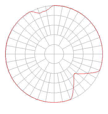 | |||||||||||||||||||||
| Azimuth | Ratio | Azimuth | Ratio | Azimuth | Ratio | Azimuth | Ratio | |||||||||||||||
| 0 | 1.000 | 10 | 1.000 | 20 | 1.000 | 30 | 1.000 | |||||||||||||||
| 40 | 1.000 | 50 | 1.000 | 60 | 1.000 | 70 | 1.000 | |||||||||||||||
| 80 | 1.000 | 90 | 1.000 | 100 | 1.000 | 110 | 1.000 | |||||||||||||||
| 120 | 0.800 | 130 | 0.643 | 134 | 0.586 | 140 | 0.640 | |||||||||||||||
| 150 | 0.800 | 160 | 1.000 | 170 | 1.000 | 180 | 1.000 | |||||||||||||||
| 190 | 1.000 | 200 | 1.000 | 210 | 1.000 | 220 | 1.000 | |||||||||||||||
| 230 | 1.000 | 240 | 1.000 | 250 | 1.000 | 260 | 1.000 | |||||||||||||||
| 270 | 1.000 | 280 | 1.000 | 283 | 1.000 | 290 | 1.000 | |||||||||||||||
| 300 | 1.000 | 310 | 1.000 | 320 | 1.000 | 330 | 1.000 | |||||||||||||||
| 340 | 0.897 | 345 | 0.900 | 350 | 0.909 | |||||||||||||||||
Structure Registration Number 1044041 Structure Type: TOWER Registered To: KENTUCKY AUTHORITY FOR EDUCATIONAL TELEVISION DBA = WKMR Structure Address: 2.6 Km E Near Usda Lookout Morehead, KY County Name: Rowan County ASR Issued: 08/03/1998 Date Built: 01/01/1968 Site Elevation: 423.4 m (1389 ft.) Structure Height: 170.8 m (560 ft.) Height Overall: 185 m (607 ft.) Overall Height AMSL: 608.4 m (1996 ft.) FAA Determination: 07/14/1998 FAA Study #: 98-ASO-4075-OE Paint & Light FAA Chapters: 1, 3, 5, 14, 21 PREV. 66-CLE-0143-OE. 38-10-38.0 N 83-24-17.0 W (NAD 83) 38-10-37.7 N 83-24-17.3 W (Converted to NAD 27) |
132 Breckinridge Hall Morehead State University Morehead, KY 40351 Phone: 606-783-2334 Government Entity | Date: 10/22/2003 Application Certifier BOARD OF REGENTS - MOREHEAD STATE UNIVERSITY 132 Breckinridge Morehead State University Morehead, KY 40351-1689 Applicant LOUIS A. WILLIAMS, JR. 2092 Arrowood Place Cincinnati, OH 45231-2241 REGISTERED PROFESSIONAL ENGINEER LOUIS A. WILLIAMS, JR. Louis A. Williams, Jr. And Associates | ||||||||||||||||||||
| ||||||||||||||||||||||