
FCCInfo.com
A Service of Cavell, Mertz & Associates, Inc.
(855) FCC-INFO
|
|
W280EW from 12/31/2013 |
|
|
||||||||||||||||
|
|
W280EW Channel: 280D 103.9 MHz Wheeling, West Virginia Service: FX - A translator or application for a translator. Facility ID: 140908 Fac. Service: FX Programming Delivery Method: Unspecified Status: License Application Accepted: 05/11/2017 Application Granted: 05/25/2017 File Number: BLFT-20170511AAE License Expires: 00/00/0000 Prefix Type: This is a license for a translator Application Type: License To Cover FCC Website Links: LMS Facility Details This Application CDBS Application Other W280EW Applications Other W280EW Applications in CDBS Including Superseded Applications Mailing Address Correspondence for W280EW Correspondence related to application BLFT-20170511AAE Service Contour - Open Street Map or USGS Map (60 dBu) Service Contour - KML / Google Earth (60 dBu) Class: D, A Noncommercial educational operating with no more than 10W Site Location: 40-03-41.3 N 80-45-07.3 W (NAD 83) Site Location: 40-03-41.0 N 80-45-08.0 W (Converted to NAD 27) Effective Radiated Power: 0 kW Horiz. ; 0.25 kW Vert. Transmitter Output Power: 0.235 kW Antenna Center HAAT: 0 m Antenna Center AMSL: 0 m Horiz.; 491 m Vert. Antenna Center HAG: 0 m Horiz.; 99 m Vert. Site Elevation: 392 m. (1286 ft.) Height Overall*: 225 m (738 ft.) (* As Filed In This Application, may differ from ASR Data, Below.) Directional Antenna Antenna Make/Model: None Antenna ID: 127026 Polarization:
| ||||||||||||||||||
| Antenna Data for Antenna Id: 127026 W280EW FX File: BLFT-20170511AAE None - Service: FX | 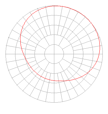 | ||||||||||||||||||
| Azimuth | Ratio | Azimuth | Ratio | Azimuth | Ratio | Azimuth | Ratio | ||||||||||||
| 0 | 0.987 | 10 | 0.995 | 20 | 0.999 | 30 | 1.000 | ||||||||||||
| 40 | 0.999 | 50 | 0.995 | 60 | 0.987 | 70 | 0.975 | ||||||||||||
| 80 | 0.956 | 90 | 0.929 | 100 | 0.892 | 110 | 0.845 | ||||||||||||
| 120 | 0.792 | 130 | 0.735 | 140 | 0.679 | 150 | 0.630 | ||||||||||||
| 160 | 0.592 | 170 | 0.566 | 180 | 0.549 | 190 | 0.540 | ||||||||||||
| 200 | 0.535 | 210 | 0.534 | 220 | 0.535 | 230 | 0.540 | ||||||||||||
| 240 | 0.549 | 250 | 0.566 | 260 | 0.592 | 270 | 0.630 | ||||||||||||
| 280 | 0.679 | 290 | 0.735 | 300 | 0.792 | 310 | 0.845 | ||||||||||||
| 320 | 0.892 | 330 | 0.929 | 340 | 0.956 | 350 | 0.975 | ||||||||||||
Structure Registration Number 1035146 Structure Type: Registered To: Nexstar Media Inc. Structure Address: Twr 1 Kirkwood Hgts Bridgeport, OH County Name: Belmont County ASR Issued: 05/28/2021 Date Built: 02/17/2009 Site Elevation: 391.6 m (1285 ft.) Structure Height: 195 m (640 ft.) Height Overall: 225 m (738 ft.) Overall Height AMSL: 616.6 m (2023 ft.) FAA Determination: 09/04/1962 FAA Study #: 1-OE-1765 Paint & Light FAA Chapters: 1, 3, 5, 14, 21 RED LIGHTS/PAINT 40-03-41.3 N 80-45-07.3 W (NAD 83) 40-03-41.0 N 80-45-08.0 W (Converted to NAD 27) |
7136 S. Yale Avenue Suite 501 Tulsa, OK 74136 Phone: 918-664-4581 | Date: 05/11/2017 Application Certifier CAPSTAR TX LLC 2625 S. Memorial Drive, Suite A Tulsa, OK 74129 Applicant MICHAEL GUIDOTTI 2625 S Memorial Dr Suite A Tulsa, OK 74129 REGIONAL ENGINEER TROY LANGHAM Iheartmedia, Inc. 2625 S. Memorial Drive, Suite A Tulsa, OK 74129 | |||||||||||||||||