
FCCInfo.com
A Service of Cavell, Mertz & Associates, Inc.
(855) FCC-INFO
|
|
WBNZ from 04/05/2001 WBNZ from 07/13/1999 WBNZ from 07/19/1996 WBNZ from 06/17/1994 WBNZ from 08/05/1994 |
|  |
|
|||||||||||||||
|
|
WBNZ Channel: 222C2 92.3 MHz Frankfort, Michigan Service: FM - A full-service FM station or application. Facility ID: 57414 Fac. Service: FM Status: License (Licensed And Silent) 73.215 Station Application Accepted: 02/24/2011 Application Granted: 05/06/2011 File Number: BLH-20110224AAK License Expires: 00/00/0000 Prefix Type: This is a license for a commercial FM station Application Type: Amendment FCC Website Links: LMS Facility Details This Application CDBS Application Other WBNZ Applications Other WBNZ Applications in CDBS Including Superseded Applications Mailing Address Correspondence for WBNZ Correspondence related to application BLH-20110224AAK Service Contour - Open Street Map or USGS Map (60 dBu) Service Contour - KML / Google Earth (60 dBu) Public Inspection Files Facility Type: FM STATION Class: C2, A Zone II station; with 25kW-50kW ERP and a class contour distance 39km-52km Site Location: 44-36-38.0 N 86-09-38.3 W (NAD 83) Site Location: 44-36-38.0 N 86-09-38.0 W (Converted to NAD 27) Effective Radiated Power: 50 kW Transmitter Output Power: 23 kW Antenna Center HAAT: 136 m (446 ft.) Antenna Center AMSL: 346 m (1135 ft.) Antenna Center HAG: 84 m (276 ft.) Calculated Site Elevation: 262 m. (860 ft.) Height Overall*: 92 m (302 ft.) (* As Filed In This Application, may differ from ASR Data, Below.) Directional Antenna Antenna Make/Model: Electronics Research Inc. MP-3E-DA Antenna ID: 94604 Polarization: | ||||||||||||||||||
| Antenna Data for Antenna Id: 94604 WBNZ FM File: BLH-20110224AAK Electronics Research Inc. - MP-3E-DA Service: FM | 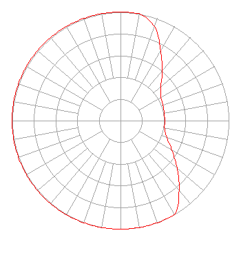 | ||||||||||||||||||
| Azimuth | Ratio | Azimuth | Ratio | Azimuth | Ratio | Azimuth | Ratio | ||||||||||||
| 0 | 1.000 | 10 | 1.000 | 20 | 0.920 | 30 | 0.740 | ||||||||||||
| 40 | 0.598 | 50 | 0.486 | 60 | 0.431 | 70 | 0.417 | ||||||||||||
| 80 | 0.409 | 90 | 0.408 | 100 | 0.413 | 110 | 0.453 | ||||||||||||
| 120 | 0.547 | 130 | 0.680 | 140 | 0.840 | 150 | 1.000 | ||||||||||||
| 160 | 1.000 | 170 | 1.000 | 180 | 1.000 | 190 | 1.000 | ||||||||||||
| 200 | 1.000 | 210 | 1.000 | 220 | 1.000 | 230 | 1.000 | ||||||||||||
| 240 | 1.000 | 250 | 1.000 | 260 | 1.000 | 270 | 1.000 | ||||||||||||
| 280 | 1.000 | 290 | 1.000 | 300 | 1.000 | 310 | 1.000 | ||||||||||||
| 320 | 1.000 | 330 | 1.000 | 340 | 1.000 | 350 | 1.000 | ||||||||||||
Structure Registration Number 1023398 Structure Type: TOWER Structure Address: 1532 Forrester Rd Frankfort, MI County Name: Benzie County ASR Issued: 05/23/2012 Date Built: 10/01/1978 Site Elevation: 262.1 m (860 ft.) Structure Height: 92 m (302 ft.) Height Overall: 92.1 m (302 ft.) Overall Height AMSL: 354.2 m (1162 ft.) FAA Determination: 12/12/1996 FAA Study #: 96-AGL-3577-OE FAA Circular #: 70/7460-1J Paint & Light FAA Chapters: 3, 4, 5, 13 44-36-38.0 N 86-09-38.0 W (NAD 83) 44-36-38.0 N 86-09-37.7 W (Converted to NAD 27) |
Brenham, TX 77833 Phone: 231-947-3220 Individual | Date: 02/24/2011 Application Certifier ROY E. HENDERSON Po Box 709 Traverse City, MI 49685 Applicant GARY L. GRAHAM Po Box 3030 Weatherford, TX 76086 TECHNICAL CONSULTANT GARY GRAHAM Gary Graham Broadcast Engineering | |||||||||||||||||