
FCCInfo.com
A Service of Cavell, Mertz & Associates, Inc.
(855) FCC-INFO
|
|
|
|  |
|
|||||||||||||||
|
|
WWFR Channel: 219A 91.7 MHz Stuart, Florida Service: FM - A full-service FM station or application. Facility ID: 20785 Fac. Service: FM Status: License Application Accepted: 11/18/2013 Application Granted: 12/06/2013 File Number: BMLED-20131118ALW License Expires: 00/00/0000 Prefix Type: This is a modification of license for a noncommercial educational FM station Application Type: Minor Modification FCC Website Links: LMS Facility Details This Application CDBS Application Other WWFR Applications Other WWFR Applications in CDBS Including Superseded Applications Mailing Address Correspondence for WWFR Correspondence related to application BMLED-20131118ALW Service Contour - Open Street Map or USGS Map (60 dBu) Service Contour - KML / Google Earth (60 dBu) Public Inspection Files Facility Type: NON-COMMERCIAL EDUC. FM Class: A, A Zone I; I-A; or II station; with 0.1kW-6kW ERP and a class contour distance <=28km Site Location: 27-07-15.2 N 80-23-58.2 W (NAD 83) Site Location: 27-07-14.0 N 80-23-59.0 W (Converted to NAD 27) Effective Radiated Power: 2.65 kW Transmitter Output Power: 1.55 kW Antenna Center HAAT: 152 m (499 ft.) Antenna Center AMSL: 157 m (515 ft.) Antenna Center HAG: 148 m (486 ft.) Site Elevation: 9 m. (30 ft.) Height Overall*: 152 m (499 ft.) (* As Filed In This Application, may differ from ASR Data, Below.) Directional Antenna Antenna Make/Model: Jampro JMPC-2 DA Antenna ID: 15578 Polarization: | ||||||||||||||||||
| Antenna Data for Antenna Id: 15578 WWFR FM File: BMLED-20131118ALW Jampro - JMPC-2 DA Service: FM | 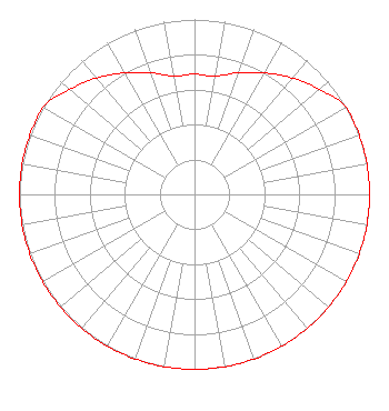 | ||||||||||||||||||
| Azimuth | Ratio | Azimuth | Ratio | Azimuth | Ratio | Azimuth | Ratio | ||||||||||||
| 0 | 0.687 | 10 | 0.687 | 20 | 0.740 | 30 | 0.801 | ||||||||||||
| 40 | 0.869 | 50 | 0.932 | 60 | 1.000 | 70 | 1.000 | ||||||||||||
| 80 | 1.000 | 90 | 1.000 | 100 | 1.000 | 110 | 1.000 | ||||||||||||
| 120 | 1.000 | 130 | 1.000 | 140 | 1.000 | 150 | 1.000 | ||||||||||||
| 160 | 1.000 | 170 | 1.000 | 180 | 1.000 | 190 | 1.000 | ||||||||||||
| 200 | 1.000 | 210 | 1.000 | 220 | 1.000 | 230 | 1.000 | ||||||||||||
| 240 | 1.000 | 250 | 1.000 | 260 | 1.000 | 270 | 1.000 | ||||||||||||
| 280 | 1.000 | 290 | 1.000 | 300 | 1.000 | 310 | 0.932 | ||||||||||||
| 320 | 0.869 | 330 | 0.801 | 340 | 0.740 | 350 | 0.687 | ||||||||||||
Structure Registration Number 1018575 [ASR Heights Differ from WWFR Application] Structure Type: GTOWER Registered To: American Towers LLC Structure Address: 12008 Sw Martin Hwy (#5050) Palm City, FL County Name: Martin County ASR Issued: 01/03/2020 Date Built: 09/15/1997 Site Elevation: 9.8 m (32 ft.) Structure Height: 152.4 m (500 ft.) Height Overall: 152.4 m (500 ft.) Overall Height AMSL: 162.2 m (532 ft.) FAA Determination: 12/23/2019 FAA Study #: 2019-ASO-33911-OE FAA Circular #: 70/7460-1L Paint & Light FAA Chapters: 4, 8, 12 PRIOR STUDY 2007-ASO-893-OE 27-07-17.5 N 80-23-57.8 W (NAD 83) 27-07-16.3 N 80-23-58.6 W (Converted to NAD 27) |
112 North Elm Street Shenandoah, IA 51601 Phone: 712-246-5151 Corporation | Date: 11/18/2013 Application Certifier FAMILY STATIONS, INC. 4135 Northgate Blvd., Suite 1 Sacramento, CA 95834 Applicant LINDA ADAMS 4135 Northgate Blvd. Suite 1 Sacramento, CA 95834 TECHNICAL CONSULTANT MICHELLE A. MCCLURE, ESQ. Fletcher, Heald & Hildreth, P.l.c. | |||||||||||||||||