
FCCInfo.com
A Service of Cavell, Mertz & Associates, Inc.
(855) FCC-INFO
|
|
|
|
|
||||||||||||||||
|
|
WLMN Channel: 209C3 89.7 MHz Manistee, Michigan Service: FM - A full-service FM station or application. Facility ID: 172572 Fac. Service: FM Status: License Application Accepted: 07/28/2010 Application Granted: 08/03/2010 File Number: BLED-20100728AFC License Expires: 00/00/0000 Prefix Type: This is a license for a noncommercial educational FM station Application Type: License To Cover FCC Website Links: LMS Facility Details This Application CDBS Application Other WLMN Applications Other WLMN Applications in CDBS Including Superseded Applications Mailing Address Correspondence for WLMN Correspondence related to application BLED-20100728AFC Service Contour - Open Street Map or USGS Map (60 dBu) Service Contour - KML / Google Earth (60 dBu) Public Inspection Files Facility Type: NON-COMMERCIAL EDUC. FM Class: C3, A Zone II station; with 6kW-25kW ERP and a class contour distance 28km-39km Site Location: 44-06-18.0 N 86-15-01.3 W (NAD 83) Site Location: 44-06-18.0 N 86-15-01.0 W (Converted to NAD 27) Effective Radiated Power: 15 kW Transmitter Output Power: 3.41 kW Antenna Center HAAT: 86 m (282 ft.) Antenna Center AMSL: 292 m (958 ft.) Antenna Center HAG: 76 m (249 ft.) Calculated Site Elevation: 216 m. (709 ft.) Height Overall*: 83 m (272 ft.) (* As Filed In This Application, may differ from ASR Data, Below.) Directional Antenna Antenna Make/Model: None Dielectric DCRH4ERD, 4 section Antenna ID: 86615 Polarization: | ||||||||||||||||||
| Antenna Data for Antenna Id: 86615 WLMN FM File: BLED-20100728AFC None - Dielectric DCRH4ERD, 4 section Service: FM | 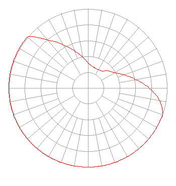 | ||||||||||||||||||
| Azimuth | Ratio | Azimuth | Ratio | Azimuth | Ratio | Azimuth | Ratio | ||||||||||||
| 0 | 0.316 | 10 | 0.281 | 20 | 0.266 | 30 | 0.266 | ||||||||||||
| 40 | 0.281 | 50 | 0.335 | 60 | 0.386 | 70 | 0.486 | ||||||||||||
| 80 | 0.612 | 90 | 0.771 | 100 | 0.916 | 110 | 1.000 | ||||||||||||
| 120 | 1.000 | 130 | 1.000 | 140 | 1.000 | 150 | 1.000 | ||||||||||||
| 160 | 1.000 | 170 | 1.000 | 180 | 1.000 | 190 | 1.000 | ||||||||||||
| 200 | 1.000 | 210 | 1.000 | 220 | 1.000 | 230 | 1.000 | ||||||||||||
| 240 | 1.000 | 250 | 1.000 | 260 | 1.000 | 270 | 1.000 | ||||||||||||
| 280 | 1.000 | 290 | 1.000 | 300 | 1.000 | 310 | 0.999 | ||||||||||||
| 320 | 0.793 | 330 | 0.630 | 340 | 0.501 | 350 | 0.398 | ||||||||||||
Structure Registration Number 1217840 Structure Type: TOWER Structure Address: 8137 N Ordway Rd. (kran # 93740) Freesoil, MI County Name: Mason County ASR Issued: 05/27/2003 Date Built: 02/12/2002 Site Elevation: 216.4 m (710 ft.) Structure Height: 80.8 m (265 ft.) Height Overall: 82.6 m (271 ft.) Overall Height AMSL: 299 m (981 ft.) FAA Determination: 02/12/2002 FAA Study #: 01-AGL-9366-OE FAA Circular #: 70/7460-1J Paint & Light FAA Chapters: 4, 8, 13 PRIOR STUDY 99-AGL-6030-OE 44-06-18.4 N 86-15-01.3 W (NAD 83) 44-06-18.4 N 86-15-01.0 W (Converted to NAD 27) |
P.o. Box 199 Interlochen, MI 49643 Phone: 231-276-4400 Private Not-for-Profit Educational Institution | Date: 07/28/2010 Application Certifier INTERLOCHEN CENTER FOR THE ARTS P. O. Box 199 Interlochen, MI 49643-0199 Applicant JUSTIN W. ASHER Munn-reese, Inc. P.o. Box 220, 385 Airport Dr. Coldwater, MI 49036-0220 CONSULTING ENGINEER JOHN CRIGLER, ESQ. Garvey Schubert Barer | |||||||||||||||||
| |||||||||||||||||||