
FCCInfo.com
A Service of Cavell, Mertz & Associates, Inc.
(855) FCC-INFO
|
|
|
|  |
|
|||||||||||||||||||||
|
|
WYPL Channel: 207C0 89.3 MHz Memphis, Tennessee Service: FM - A full-service FM station or application. Facility ID: 13996 Fac. Service: FM Status: License Application Accepted: 05/19/2004 Application Granted: 04/18/2005 File Number: BLED-20040519ADN License Expires: 00/00/0000 Prefix Type: This is a license for a noncommercial educational FM station Application Type: License To Cover FCC Website Links: LMS Facility Details This Application CDBS Application Other WYPL Applications Other WYPL Applications in CDBS Including Superseded Applications Mailing Address Correspondence for WYPL Correspondence related to application BLED-20040519ADN Service Contour - Open Street Map or USGS Map (60 dBu) Service Contour - KML / Google Earth (60 dBu) Public Inspection Files Facility Type: NON-COMMERCIAL EDUC. FM Class: C0, C0 Site Location: 35-28-03.3 N 90-11-27.3 W (NAD 83) Site Location: 35-28-03.0 N 90-11-27.0 W (Converted to NAD 27) Effective Radiated Power: 100 kW Transmitter Output Power: 25.2 kW Antenna Center HAAT: 382 m (1253 ft.) Antenna Center AMSL: 447 m (1467 ft.) Antenna Center HAG: 378 m (1240 ft.) Site Elevation: 69 m. (226 ft.) Height Overall*: 403 m (1322 ft.) (* As Filed In This Application, may differ from ASR Data, Below.) Directional Antenna Antenna Make/Model: Shivley 6810, four sections Antenna ID: 58838 Polarization: | ||||||||||||||||||||||||
| Antenna Data for Antenna Id: 58838 WYPL FM File: BLED-20040519ADN Shivley - 6810, four sections Service: FM | 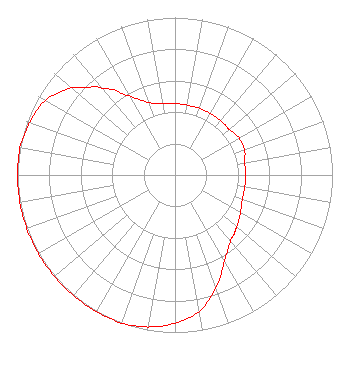 | ||||||||||||||||||||||||
| Azimuth | Ratio | Azimuth | Ratio | Azimuth | Ratio | Azimuth | Ratio | ||||||||||||||||||
| 0 | 0.455 | 10 | 0.450 | 20 | 0.450 | 30 | 0.450 | ||||||||||||||||||
| 40 | 0.450 | 45 | 0.450 | 50 | 0.450 | 60 | 0.470 | ||||||||||||||||||
| 70 | 0.470 | 80 | 0.450 | 90 | 0.450 | 100 | 0.450 | ||||||||||||||||||
| 110 | 0.455 | 120 | 0.480 | 130 | 0.510 | 135 | 0.530 | ||||||||||||||||||
| 140 | 0.550 | 150 | 0.630 | 160 | 0.760 | 170 | 0.880 | ||||||||||||||||||
| 180 | 0.940 | 190 | 0.980 | 200 | 1.000 | 210 | 1.000 | ||||||||||||||||||
| 220 | 1.000 | 225 | 1.000 | 230 | 1.000 | 240 | 1.000 | ||||||||||||||||||
| 250 | 1.000 | 260 | 1.000 | 270 | 1.000 | 280 | 1.000 | ||||||||||||||||||
| 290 | 0.980 | 300 | 0.950 | 310 | 0.860 | 315 | 0.790 | ||||||||||||||||||
| 320 | 0.720 | 330 | 0.580 | 340 | 0.490 | 350 | 0.458 | ||||||||||||||||||
Structure Registration Number 1044106 Structure Type: TOWER Registered To: COSSITT LIBRARY DBA = MEMPHIS/SHELBY CNTY PUB. LIB. & INFO CNT Structure Address: Road 308, 0.7 Km West Of Us 61 Frenchman's Bayou, AR County Name: Mississippi County ASR Issued: 04/16/1998 Date Built: 01/01/1989 Site Elevation: 68.9 m (226 ft.) Structure Height: 402.4 m (1320 ft.) Height Overall: 403.3 m (1323 ft.) Overall Height AMSL: 472.2 m (1549 ft.) FAA Determination: 03/18/1996 FAA Study #: 96-ASW-0047-OE Paint & Light FAA Chapters: B, E, H 35-28-03.0 N 90-11-27.0 W (NAD 83) 35-28-02.7 N 90-11-26.7 W (Converted to NAD 27) |
Radio Station Wypl 3030 Poplar Avenue Memphis, TN 38111 Phone: 901-415-2829 Government Entity | Date: 05/19/2004 Application Certifier MEMPHIS/SHELBY COUNTY PUBLIC LIBRARY & INFORMATION CENTER Station Wypl 3030 Poplar Ave. Memphis, TN 38111 Applicant STEVE TERRY Memphis Public Library & Information Cen 3030 Poplar Ave. Memphis, TN 38111 CHIEF ENGINEER MATTHEW H. MCCORMICK, ESQ. Reddy, Begley & Mccormick, Llp | |||||||||||||||||||||||
|
| ||||||||||||||||||||||||