
FCCInfo.com
A Service of Cavell, Mertz & Associates, Inc.
(855) FCC-INFO
|
|
WMGP from 08/02/1999 WMGP from 07/30/1999 WMGP from 01/20/1995 WMGP from 08/09/1991 |
|
|
||||||||||||||||
|
|
WMGP Channel: 251C3 98.1 MHz Hogansville, Georgia Service: FM - A full-service FM station or application. Facility ID: 39619 Fac. Service: FM Status: License 73.215 Station Application Accepted: 10/07/1999 Application Granted: 11/15/1999 File Number: BLH-19990927AAJ License Expires: 00/00/0000 Prefix Type: This is a license for a commercial FM station Application Type: License To Cover FCC Website Links: LMS Facility Details This Application CDBS Application Other WMGP Applications Other WMGP Applications in CDBS Including Superseded Applications Mailing Address Correspondence for WMGP Correspondence related to application BLH-19990927AAJ Service Contour - Open Street Map or USGS Map (60 dBu) Service Contour - KML / Google Earth (60 dBu) Public Inspection Files Facility Type: FM STATION Class: C3, A Zone II station; with 6kW-25kW ERP and a class contour distance 28km-39km Site Location: 33-03-54.4 N 84-57-22.8 W (NAD 83) Site Location: 33-03-54.0 N 84-57-23.0 W (Converted to NAD 27) Effective Radiated Power: 25 kW Transmitter Output Power: 8.9 kW Antenna Center HAAT: 100 m (328 ft.) Antenna Center AMSL: 326 m (1070 ft.) Antenna Center HAG: 113 m (371 ft.) Calculated Site Elevation: 213 m. (699 ft.) Height Overall*: 123 m (404 ft.) (* As Filed In This Application, may differ from ASR Data, Below.) Directional Antenna Antenna Make/Model: Electronics Research Inc. LP-8C-DA-HW Antenna ID: 15207 Polarization: | ||||||||||||||||||
| Antenna Data for Antenna Id: 15207 WMGP FM File: BLH-19990927AAJ Electronics Research Inc. - LP-8C-DA-HW Service: FM | 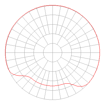 | ||||||||||||||||||
| Azimuth | Ratio | Azimuth | Ratio | Azimuth | Ratio | Azimuth | Ratio | ||||||||||||
| 0 | 1.000 | 10 | 1.000 | 20 | 1.000 | 30 | 1.000 | ||||||||||||
| 40 | 1.000 | 50 | 1.000 | 60 | 1.000 | 70 | 1.000 | ||||||||||||
| 80 | 1.000 | 90 | 1.000 | 100 | 1.000 | 110 | 1.000 | ||||||||||||
| 120 | 1.000 | 130 | 1.000 | 135 | 0.982 | 140 | 0.933 | ||||||||||||
| 150 | 0.774 | 155 | 0.725 | 160 | 0.707 | 170 | 0.707 | ||||||||||||
| 180 | 0.707 | 190 | 0.707 | 200 | 0.707 | 210 | 0.707 | ||||||||||||
| 220 | 0.707 | 225 | 0.725 | 230 | 0.774 | 240 | 0.933 | ||||||||||||
| 245 | 0.982 | 250 | 1.000 | 260 | 1.000 | 270 | 1.000 | ||||||||||||
| 280 | 1.000 | 290 | 1.000 | 300 | 1.000 | 310 | 1.000 | ||||||||||||
| 320 | 1.000 | 330 | 1.000 | 340 | 1.000 | 350 | 1.000 | ||||||||||||
Structure Registration Number 1022901 Structure Type: TOWER Registered To: Vertical Bridge CC FM, LLC Structure Address: Bell Rd Hogansville, GA County Name: Troup County ASR Issued: 11/08/2018 Date Built: 01/01/1993 Site Elevation: 213 m (699 ft.) Structure Height: 123 m (404 ft.) Height Overall: 123 m (404 ft.) Overall Height AMSL: 336 m (1102 ft.) FAA Determination: 08/24/1988 FAA Study #: 88-ASO-1273-OE FAA Circular #: 70/7460-1G Paint & Light FAA Chapters: 3, 4, 5, 9 33-03-54.0 N 84-57-23.0 W (NAD 83) 33-03-53.6 N 84-57-23.2 W (Converted to NAD 27) |
7136 S. Yale Avenue Suite 501 Tulsa, OK 74136 Phone: 918-664-4581 | Date: 09/27/1999 Application Certifier CITICASTERS CO. 200 Concord Plaza Suite 600 San Antonio, TX 78216 Applicant TECHNICAL DIRECTOR | |||||||||||||||||