
FCCInfo.com
A Service of Cavell, Mertz & Associates, Inc.
(855) FCC-INFO
|
|
|
|  |
|
|||||||||||||||
|
|
WVAV Channel: 218B1 91.5 MHz Vicksburg, Michigan Service: FM - A full-service FM station or application. Facility ID: 173547 Fac. Service: FM Status: License Application Accepted: 06/20/2013 Application Granted: 06/27/2013 File Number: BLED-20130620AAS License Expires: 00/00/0000 Prefix Type: This is a license for a noncommercial educational FM station Application Type: License To Cover FCC Website Links: LMS Facility Details This Application CDBS Application Other WVAV Applications Other WVAV Applications in CDBS Including Superseded Applications Mailing Address Correspondence for WVAV Correspondence related to application BLED-20130620AAS Service Contour - Open Street Map or USGS Map (60 dBu) Service Contour - KML / Google Earth (60 dBu) Public Inspection Files Facility Type: NON-COMMERCIAL EDUC. FM Class: B1, A Zone I or I-A station; with 6kW-25kW ERP and a class contour distance 28km-39km Site Location: 42-01-13.5 N 85-24-36.8 W (NAD 83) Site Location: 42-01-13.3 N 85-24-36.8 W (Converted to NAD 27) Effective Radiated Power: 0 kW Horiz. ; 20 kW Vert. Transmitter Output Power: 5.24 kW Antenna Center HAAT: 0 m Horiz.; 53 m Vert. Antenna Center AMSL: 0 m Horiz.; 316.6 m Vert. Antenna Center HAG: 0 m Horiz.; 60 m Vert. Site Elevation: 256.6 m. (842 ft.) Height Overall*: 69.5 m (228 ft.) (* As Filed In This Application, may differ from ASR Data, Below.) Directional Antenna Antenna Make/Model: Shivley 6014-V-2/2-DA, two sections Antenna ID: 82735 Polarization: | ||||||||||||||||||
| Antenna Data for Antenna Id: 82735 WVAV FM File: BLED-20130620AAS Shivley - 6014-V-2/2-DA, two sections Service: FM | 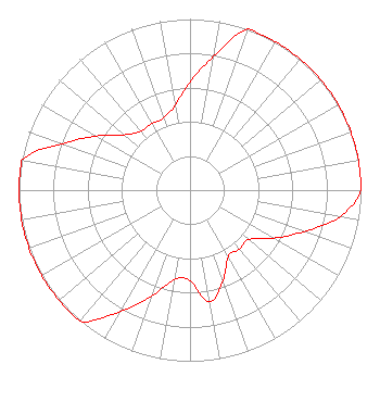 | ||||||||||||||||||
| Azimuth | Ratio | Azimuth | Ratio | Azimuth | Ratio | Azimuth | Ratio | ||||||||||||
| 0 | 0.632 | 10 | 0.795 | 20 | 1.000 | 30 | 1.000 | ||||||||||||
| 40 | 1.000 | 50 | 1.000 | 60 | 1.000 | 70 | 1.000 | ||||||||||||
| 80 | 1.000 | 90 | 1.000 | 100 | 0.890 | 110 | 0.708 | ||||||||||||
| 120 | 0.563 | 130 | 0.448 | 140 | 0.448 | 150 | 0.448 | ||||||||||||
| 160 | 0.563 | 170 | 0.660 | 180 | 0.530 | 190 | 0.530 | ||||||||||||
| 200 | 0.660 | 210 | 0.820 | 220 | 1.000 | 230 | 1.000 | ||||||||||||
| 240 | 1.000 | 250 | 1.000 | 260 | 1.000 | 270 | 1.000 | ||||||||||||
| 280 | 1.000 | 290 | 0.795 | 300 | 0.632 | 310 | 0.503 | ||||||||||||
| 320 | 0.448 | 330 | 0.448 | 340 | 0.448 | 350 | 0.503 | ||||||||||||
Structure Registration Number 1227853 Structure Type: TOWER Registered To: Crown Castle Towers 05 LLC Structure Address: 28005 Pleasant Road. Mi00521 Mendon, MI County Name: St. Joseph County ASR Issued: 05/06/2016 Date Built: 03/30/2004 Site Elevation: 256.6 m (842 ft.) Structure Height: 67.1 m (220 ft.) Height Overall: 69.5 m (228 ft.) Overall Height AMSL: 326.1 m (1070 ft.) FAA Determination: 12/18/2000 FAA Study #: 00-AGL-7908-OE FAA Circular #: 70/7460-1K Paint & Light FAA Chapters: 4, 8, 12 42-01-13.5 N 85-24-36.8 W (NAD 83) 42-01-13.3 N 85-24-36.8 W (Converted to NAD 27) |
2504 Ardmore Street, Se Grand Rapids, MI 49506-4901 Phone: 616-956-1140 | Date: 06/20/2013 Application Certifier VINEYARD ACADEMY P.o. Box 102 8510 M-89 Richland, MI 49083 Applicant DENNIS J. KELLY Law Office Of Dennis J. Kelly Post Office Box 41177 Washington, DC 20018-0577 ATTORNEY/CONSULTANT DENNIS J. KELLY Law Office Of Dennis J. Kelly | |||||||||||||||||