
FCCInfo.com
A Service of Cavell, Mertz & Associates, Inc.
(855) FCC-INFO
|
|
WKVB from 02/26/2020 |
|
|
||||||||||||||||
|
|
WKVB Channel: 297B 107.3 MHz Westborough, Massachusetts Service: FS - A full service FM station auxiliary transmitting antenna or application. Facility ID: 74467 Fac. Service: FM Analog & Digital Status: License Application Accepted: 05/12/2015 Application Granted: 05/15/2015 File Number: BXLH-20150512ACH License Expires: 00/00/0000 Prefix Type: This is BXLH Application Type: License To Cover FCC Website Links: LMS Facility Details This Application CDBS Application Other WKVB Applications Other WKVB Applications in CDBS Including Superseded Applications Mailing Address Correspondence for WKVB Correspondence related to application BXLH-20150512ACH Service Contour - Open Street Map or USGS Map (54 dBu) Service Contour - KML / Google Earth (54 dBu) Public Inspection Files History Cards for WKVB Facility Type: FM STATION Class: B, A Zone I or I-A station; with 25kW-50kW ERP and a class contour distance 39km-52km Site Location: 42-18-11.3 N 71-53-50.3 W (NAD 83) Site Location: 42-18-11.0 N 71-53-52.0 W (Converted to NAD 27) Effective Radiated Power: 15 kW Transmitter Output Power: 5.46 kW Antenna Center HAAT: 239 m (784 ft.) Antenna Center AMSL: 477 m (1565 ft.) Antenna Center HAG: 57 m (187 ft.) Calculated Site Elevation: 420 m. (1378 ft.) Height Overall*: 77 m (253 ft.) (* As Filed In This Application, may differ from ASR Data, Below.) Directional Antenna Antenna Make/Model: Shivley 6810-3R-SS(0.5)-DA, 3 bays, 0.5 wavelength spaced Antenna ID: 119686 Polarization:
| ||||||||||||||||||
| Antenna Data for Antenna Id: 119686 WKVB FS File: BXLH-20150512ACH Shivley - 6810-3R-SS(0.5)-DA, 3 bays, 0.5 wavelength spaced Service: FS | 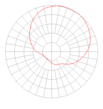 | ||||||||||||||||||
| Azimuth | Ratio | Azimuth | Ratio | Azimuth | Ratio | Azimuth | Ratio | ||||||||||||
| 0 | 0.968 | 10 | 1.000 | 20 | 1.000 | 30 | 1.000 | ||||||||||||
| 40 | 0.994 | 50 | 0.964 | 60 | 0.932 | 70 | 0.890 | ||||||||||||
| 80 | 0.836 | 90 | 0.764 | 100 | 0.684 | 110 | 0.604 | ||||||||||||
| 120 | 0.520 | 130 | 0.422 | 140 | 0.344 | 150 | 0.318 | ||||||||||||
| 160 | 0.304 | 170 | 0.274 | 180 | 0.244 | 190 | 0.214 | ||||||||||||
| 200 | 0.188 | 210 | 0.180 | 220 | 0.180 | 230 | 0.180 | ||||||||||||
| 240 | 0.184 | 250 | 0.208 | 260 | 0.254 | 270 | 0.324 | ||||||||||||
| 280 | 0.394 | 290 | 0.464 | 300 | 0.536 | 310 | 0.616 | ||||||||||||
| 320 | 0.700 | 330 | 0.796 | 340 | 0.874 | 350 | 0.936 | ||||||||||||
Structure Registration Number 1003939 Structure Type: TOWER Registered To: RADIO TOWER COMMUNICATION CORP Structure Address: Asnebumskit Rd Paxton, MA County Name: Worcester County ASR Issued: 11/15/1996 Date Built: 01/01/1933 Site Elevation: 420.3 m (1379 ft.) Structure Height: 74.6 m (245 ft.) Height Overall: 76.8 m (252 ft.) Overall Height AMSL: 497.1 m (1631 ft.) FAA Determination: 01/31/1996 FAA Study #: 95-ANE-0472-OE FAA Circular #: 70/7460-1H Paint & Light FAA Chapters: 3, 4, 5, 13 42-18-11.0 N 71-53-50.0 W (NAD 83) 42-18-10.7 N 71-53-51.7 W (Converted to NAD 27) |
5700 West Oaks Blvd. Rocklin, CA 95765 Phone: 916-251-1600 Not-for-Profit | Date: 05/12/2015 Application Certifier ENTERCOM LICENSE, LLC 401 E. City Avenue Suite 809 Bala Cynwyd, PA 19004 Applicant CLARENCE M BEVERAGE Communications Technologies, Inc. P.o. Box 1130 Marlton, NJ 08053 BROADCAST ENGINEERING CONSULTANT CARRIE A. WARD, ESQ. Entercom Communications Corp. | |||||||||||||||||