
FCCInfo.com
A Service of Cavell, Mertz & Associates, Inc.
(855) FCC-INFO
|
|
KYUA from 05/26/2005 KYUA from 04/07/1999 |
|
|
||||||||||||||||
|
|
KYUA Channel: 203B1 88.5 MHz Inyokern, California Service: FM - A full-service FM station or application. Facility ID: 93175 Fac. Service: FM Status: License Application Accepted: 04/24/2008 Application Granted: 05/23/2008 File Number: BLED-20080424ACC License Expires: 00/00/0000 Prefix Type: This is a license for a noncommercial educational FM station Application Type: Amendment FCC Website Links: LMS Facility Details This Application CDBS Application Other KYUA Applications Other KYUA Applications in CDBS Including Superseded Applications Mailing Address Correspondence for KYUA Correspondence related to application BLED-20080424ACC Service Contour - Open Street Map or USGS Map (60 dBu) Service Contour - KML / Google Earth (60 dBu) Public Inspection Files Facility Type: NON-COMMERCIAL EDUC. FM Class: B1, A Zone I or I-A station; with 6kW-25kW ERP and a class contour distance 28km-39km Site Location: 35-28-38.9 N 117-42-01.2 W (NAD 83) Site Location: 35-28-39.0 N 117-41-58.0 W (Converted to NAD 27) Effective Radiated Power: 1 kW Transmitter Output Power: 0.391 kW Antenna Center HAAT: 396 m (1299 ft.) Antenna Center AMSL: 1360 m (4462 ft.) Antenna Center HAG: 27 m (89 ft.) Calculated Site Elevation: 1333 m. (4373 ft.) Height Overall*: 46 m (151 ft.) (* As Filed In This Application, may differ from ASR Data, Below.) Directional Antenna Antenna Make/Model: Scala CA5-FM/CP/RM-1/1 Antenna ID: 79922 Polarization:
| ||||||||||||||||||
| Antenna Data for Antenna Id: 79922 KYUA FM File: BLED-20080424ACC Scala - CA5-FM/CP/RM-1/1 Service: FM | 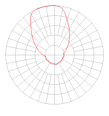 | ||||||||||||||||||
| Azimuth | Ratio | Azimuth | Ratio | Azimuth | Ratio | Azimuth | Ratio | ||||||||||||
| 0 | 1.000 | 10 | 0.944 | 20 | 0.750 | 30 | 0.599 | ||||||||||||
| 40 | 0.476 | 50 | 0.378 | 60 | 0.300 | 70 | 0.239 | ||||||||||||
| 80 | 0.189 | 90 | 0.185 | 100 | 0.190 | 110 | 0.178 | ||||||||||||
| 120 | 0.178 | 130 | 0.178 | 140 | 0.178 | 150 | 0.178 | ||||||||||||
| 160 | 0.182 | 170 | 0.193 | 180 | 0.182 | 190 | 0.178 | ||||||||||||
| 200 | 0.178 | 210 | 0.178 | 220 | 0.178 | 230 | 0.178 | ||||||||||||
| 240 | 0.190 | 250 | 0.185 | 260 | 0.189 | 270 | 0.239 | ||||||||||||
| 280 | 0.300 | 290 | 0.378 | 300 | 0.476 | 310 | 0.596 | ||||||||||||
| 320 | 0.750 | 330 | 0.944 | 340 | 1.000 | 350 | 1.000 | ||||||||||||
Structure Registration Number 1022898 Structure Type: TOWER Registered To: KITCHEN PRODUCTIONS INC DBA = TORTOISE COMMUNICATIONS Structure Address: El Paso Peaks Electronic Site Ridgecrest, CA County Name: Kern County ASR Issued: 06/19/1997 Date Built: 06/01/1991 Site Elevation: 1332.7 m (4372 ft.) Structure Height: 42.4 m (139 ft.) Height Overall: 45.7 m (150 ft.) Overall Height AMSL: 1378.4 m (4522 ft.) Paint & Light FAA Chapters: None 35-28-39.0 N 117-42-01.0 W (NAD 83) 35-28-39.1 N 117-41-57.8 W (Converted to NAD 27) |
5700 West Oaks Boulevard Rocklin, CA 95765 Phone: 916-251-1600 Not-for-Profit | Date: 04/24/2008 Application Certifier EDUCATIONAL MEDIA FOUNDATION 5700 West Oaks Blvd Rocklin, CA 95765 Applicant SAM WALLINGTON 5700 West Oaks Blvd Rocklin, CA 95765 VP OF ENGINEERING DAVID D. OXENFORD, ESQ Davis Wright Tremaine Llp | |||||||||||||||||