
FCCInfo.com
A Service of Cavell, Mertz & Associates, Inc.
(855) FCC-INFO
|
|
|
|
|
||||||||||||||||
|
|
K294CR Channel: 294D 106.7 MHz Tucson, Arizona Service: FX - A translator or application for a translator. Facility ID: 152140 Fac. Service: FX Programming Delivery Method: Unspecified Status: License Application Accepted: 02/21/2017 Application Granted: 03/07/2017 File Number: BLFT-20170221AAX License Expires: 00/00/0000 Prefix Type: This is a license for a translator Application Type: License To Cover FCC Website Links: LMS Facility Details This Application CDBS Application Other K294CR Applications Other K294CR Applications in CDBS Including Superseded Applications Mailing Address Correspondence for K294CR Correspondence related to application BLFT-20170221AAX Service Contour - Open Street Map or USGS Map (60 dBu) Service Contour - KML / Google Earth (60 dBu) Class: D, A Noncommercial educational operating with no more than 10W Site Location: 32-14-57.3 N 111-06-59.3 W (NAD 83) Site Location: 32-14-57.0 N 111-06-56.9 W (Converted to NAD 27) Effective Radiated Power: 0.067 kW Transmitter Output Power: 0.05 kW Antenna Center HAAT: 0 m Antenna Center AMSL: 1341 m (4400 ft.) Antenna Center HAG: 16 m (52 ft.) Site Elevation: 1325 m. (4347 ft.) Height Overall*: 60 m (197 ft.) (* As Filed In This Application, may differ from ASR Data, Below.) Directional Antenna Antenna Make/Model: None Antenna ID: 16150 Polarization:
| ||||||||||||||||||
| Antenna Data for Antenna Id: 16150 K294CR FX File: BLFT-20170221AAX None - Service: FX Pattern and Field Values Include a 55° Clockwise Rotation | 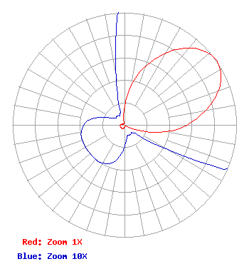 | ||||||||||||||||||
| Azimuth | Ratio | Azimuth | Ratio | Azimuth | Ratio | Azimuth | Ratio | ||||||||||||
| 5 | 0.250 | 15 | 0.470 | 25 | 0.645 | 35 | 0.820 | ||||||||||||
| 45 | 0.950 | 55 | 1.000 | 65 | 0.950 | 75 | 0.820 | ||||||||||||
| 85 | 0.645 | 95 | 0.470 | 105 | 0.250 | 115 | 0.085 | ||||||||||||
| 125 | 0.020 | 135 | 0.010 | 145 | 0.010 | 155 | 0.010 | ||||||||||||
| 165 | 0.010 | 175 | 0.015 | 185 | 0.025 | 195 | 0.034 | ||||||||||||
| 205 | 0.038 | 215 | 0.040 | 225 | 0.040 | 235 | 0.040 | ||||||||||||
| 245 | 0.040 | 255 | 0.040 | 265 | 0.038 | 275 | 0.034 | ||||||||||||
| 285 | 0.025 | 295 | 0.015 | 305 | 0.010 | 315 | 0.010 | ||||||||||||
| 325 | 0.010 | 335 | 0.010 | 345 | 0.020 | 355 | 0.085 | ||||||||||||
Structure Registration Number 1218220 [ASR Heights Differ from K294CR Application] Structure Type: GTOWER Registered To: American Towers LLC Structure Address: 7120 W. Lost Canyon Rd. (tucson Mtn, T5 #8171--dsm) Tucson, AZ County Name: Pima County ASR Issued: 09/01/2020 Date Built: 01/26/1998 Site Elevation: 1334.1 m (4377 ft.) Structure Height: 60.1 m (197 ft.) Height Overall: 60.1 m (197 ft.) Overall Height AMSL: 1394.2 m (4574 ft.) FAA Determination: 08/31/2020 FAA Study #: 2020-AWP-9090-OE Paint & Light FAA Chapters: NONE PRIOR STUDY 2011-AWP-6649-OE 32-14-56.2 N 111-07-01.1 W (NAD 83) 32-14-55.9 N 111-06-58.7 W (Converted to NAD 27) |
4111 Plains Blvd Amarillo, TX 79106 Phone: 208-733-3551 | Date: 02/21/2017 Application Certifier EDGEWATER BROADCASTING, INC. 160 W Gooding Street Twin Falls, ID 83301 Applicant GENE WISNIEWSKI 160 Gooding Street West Suite A Twin Falls, ID 83301 CONSULTING ENGINEER CLARK PARRISH Edgewater Broadcasting, Inc. 160 W Gooding Street Twin Falls, ID 83301 | |||||||||||||||||