
FCCInfo.com
A Service of Cavell, Mertz & Associates, Inc.
(855) FCC-INFO
|
|
|
|
|
||||||||||||||||
|
|
W248AW Channel: 248D 97.5 MHz Indianapolis, Indiana Service: FX - A translator or application for a translator. Facility ID: 140551 Fac. Service: FX Programming Delivery Method: Unspecified Status: License Application Accepted: 07/18/2019 Application Granted: 07/24/2019 File Number: BMLFT-20190718AAF License Expires: 00/00/0000 Prefix Type: This is a modification of license for a translator Application Type: Minor Modification FCC Website Links: LMS Facility Details This Application CDBS Application Other W248AW Applications Other W248AW Applications in CDBS Including Superseded Applications Mailing Address Correspondence for W248AW Correspondence related to application BMLFT-20190718AAF Service Contour - Open Street Map or USGS Map (60 dBu) Service Contour - KML / Google Earth (60 dBu) Class: D, A Noncommercial educational operating with no more than 10W Site Location: 39-53-40.0 N 86-12-21.0 W (NAD 83) Site Location: 39-53-39.9 N 86-12-21.0 W (Converted to NAD 27) Effective Radiated Power: 0 kW Horiz. ; 0.15 kW Vert. Transmitter Output Power: 0.159 kW Antenna Center HAAT: 0 m Antenna Center AMSL: 0 m Horiz.; 527 m Vert. Antenna Center HAG: 0 m Horiz.; 272 m Vert. Site Elevation: 255 m. (837 ft.) Height Overall*: 308 m (1010 ft.) (* As Filed In This Application, may differ from ASR Data, Below.) Directional Antenna Antenna Make/Model: None Antenna ID: 121459 Polarization:
| ||||||||||||||||||
| Antenna Data for Antenna Id: 121459 W248AW FX File: BMLFT-20190718AAF None - Service: FX | 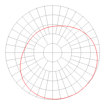 | ||||||||||||||||||
| Azimuth | Ratio | Azimuth | Ratio | Azimuth | Ratio | Azimuth | Ratio | ||||||||||||
| 0 | 0.551 | 10 | 0.570 | 20 | 0.599 | 30 | 0.639 | ||||||||||||
| 40 | 0.689 | 50 | 0.746 | 60 | 0.803 | 70 | 0.856 | ||||||||||||
| 80 | 0.900 | 90 | 0.935 | 100 | 0.961 | 110 | 0.978 | ||||||||||||
| 120 | 0.990 | 130 | 0.995 | 140 | 0.999 | 150 | 1.000 | ||||||||||||
| 160 | 0.998 | 170 | 0.993 | 180 | 0.985 | 190 | 0.972 | ||||||||||||
| 200 | 0.952 | 210 | 0.923 | 220 | 0.883 | 230 | 0.836 | ||||||||||||
| 240 | 0.781 | 250 | 0.723 | 260 | 0.668 | 270 | 0.622 | ||||||||||||
| 280 | 0.586 | 290 | 0.562 | 300 | 0.546 | 310 | 0.538 | ||||||||||||
| 320 | 0.535 | 330 | 0.534 | 340 | 0.536 | 350 | 0.541 | ||||||||||||
Structure Registration Number 1253064 [ASR Heights Differ from W248AW Application] Structure Type: GTOWER Registered To: American Towers LLC Structure Address: 7701 Walnut Drive (282661) Indianapolis, IN County Name: Marion County ASR Issued: 02/29/2024 Date Built: 07/24/2006 Site Elevation: 252.7 m (829 ft.) Structure Height: 259 m (850 ft.) Height Overall: 307.8 m (1010 ft.) Overall Height AMSL: 560.5 m (1839 ft.) FAA Determination: 06/29/2015 FAA Study #: 2015-AGL-6839-OE FAA Circular #: 70/7460-1K Paint & Light FAA Chapters: 4, 9, 12 OM&L to remain the same as prior study = A HIGH-DUAL SYSTEM 39-53-39.2 N 86-12-20.5 W (NAD 83) 39-53-39.1 N 86-12-20.5 W (Converted to NAD 27) |
5700 West Oaks Blvd. Rocklin, CA 95765 Phone: 916-251-1600 | Date: 07/18/2019 Application Certifier CAPSTAR TX, LLC 7136 S. Yale Avenue Suite 501 Tulsa, OK 74136 Applicant TROY G. LANGHAM 7136 South Yale Avenue Suite 501 Tulsa, OK 74136 VP, TECHNICAL REGULATORY AFFAIRS CAPSTAR TX, LLC Capstar Tx, Llc 7136 S. Yale Avenue Suite 501 Tulsa, OK 74136 | |||||||||||||||||