
FCCInfo.com
A Service of Cavell, Mertz & Associates, Inc.
(855) FCC-INFO
|
|
|
|  |
|
|||||||||||||||
|
|
KSQM Channel: 218A 91.5 MHz Sequim, Washington Service: FM - A full-service FM station or application. Facility ID: 172153 Fac. Service: FM Status: License Application Accepted: 11/12/2015 Application Granted: 11/20/2015 File Number: BLED-20151112XON License Expires: 00/00/0000 Prefix Type: This is a license for a noncommercial educational FM station Application Type: License To Cover FCC Website Links: LMS Facility Details This Application CDBS Application Other KSQM Applications Other KSQM Applications in CDBS Including Superseded Applications Mailing Address Correspondence for KSQM Correspondence related to application BLED-20151112XON Service Contour - Open Street Map or USGS Map (60 dBu) Service Contour - KML / Google Earth (60 dBu) Public Inspection Files Facility Type: NON-COMMERCIAL EDUC. FM Class: A, A Zone I; I-A; or II station; with 0.1kW-6kW ERP and a class contour distance <=28km Site Location: 48-05-00.3 N 123-16-01.6 W (NAD 83) Site Location: 48-05-01.0 N 123-15-56.9 W (Converted to NAD 27) Effective Radiated Power: 2.05 kW Transmitter Output Power: 1.122 kW Antenna Center HAAT: -62 m Antenna Center AMSL: 207 m (679 ft.) Antenna Center HAG: 44 m (144 ft.) Calculated Site Elevation: 163 m. (535 ft.) Height Overall*: 48 m (157 ft.) (* As Filed In This Application, may differ from ASR Data, Below.) Directional Antenna Antenna Make/Model: Propagation System Inc FM3-DA Antenna ID: 118714 Polarization: | ||||||||||||||||||
| Antenna Data for Antenna Id: 118714 KSQM FM File: BLED-20151112XON Propagation System Inc - FM3-DA Service: FM | 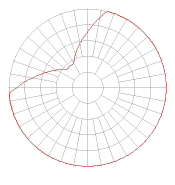 | ||||||||||||||||||
| Azimuth | Ratio | Azimuth | Ratio | Azimuth | Ratio | Azimuth | Ratio | ||||||||||||
| 0 | 0.708 | 10 | 0.891 | 15 | 1.000 | 20 | 1.000 | ||||||||||||
| 30 | 1.000 | 40 | 1.000 | 50 | 1.000 | 60 | 1.000 | ||||||||||||
| 70 | 1.000 | 80 | 1.000 | 90 | 1.000 | 100 | 1.000 | ||||||||||||
| 110 | 1.000 | 120 | 1.000 | 130 | 1.000 | 140 | 1.000 | ||||||||||||
| 150 | 1.000 | 160 | 1.000 | 170 | 1.000 | 180 | 1.000 | ||||||||||||
| 190 | 1.000 | 200 | 1.000 | 210 | 1.000 | 220 | 1.000 | ||||||||||||
| 230 | 1.000 | 240 | 1.000 | 250 | 1.000 | 260 | 1.000 | ||||||||||||
| 265 | 1.000 | 270 | 0.891 | 280 | 0.708 | 290 | 0.562 | ||||||||||||
| 300 | 0.447 | 310 | 0.355 | 320 | 0.355 | 330 | 0.355 | ||||||||||||
| 340 | 0.447 | 350 | 0.562 | ||||||||||||||||
Structure Registration Number 1275623 Structure Type: LTOWER Registered To: Sequim Community Broadcasting Structure Address: East Of Blue Mountain Road, South Of Highway 101 Port Angeles, WA County Name: Clallam County ASR Issued: 06/22/2014 Date Built: 10/04/2013 Site Elevation: 163.5 m (536 ft.) Structure Height: 47.2 m (155 ft.) Height Overall: 48 m (157 ft.) Overall Height AMSL: 211.5 m (694 ft.) FAA Determination: 06/03/2014 FAA Study #: 2014-ANM-671-OE Paint & Light FAA Chapters: NONE PRIOR STUDY 2013-ANM-2682-OE 48-05-00.8 N 123-16-02.2 W (NAD 83) 48-05-01.5 N 123-15-57.5 W (Converted to NAD 27) |
Sequim, WA 98382 Phone: 360-681-0000 Not-for-Profit | Date: 11/12/2015 Application Certifier SEQUIM COMMUNITY BROADCASTING P.o. Box 723 Sequim, WA 98382 Applicant JOHN JOSEPH MCVEIGH 16230 Falls Road Box 128 Butler, MD 21023-0128 COMMUNICATIONS COUNSEL JOHN JOSEPH MCVEIGH, ESQ. J.j. Mcveigh, Attorney At Law | |||||||||||||||||
| |||||||||||||||||||