
FCCInfo.com
A Service of Cavell, Mertz & Associates, Inc.
(855) FCC-INFO
|
|
KVEO-TV from 12/10/1981 KVEO-TV from 11/10/1980 |
Virtual Channel 23 |  |
|
|||||||||||||||||||||
|
|
Repacking Information: No changes Status: License Application Accepted: 06/30/2005 License Expires: 08/01/2022 File Number: BLCDT-20050630AGL Prefix Type: This is a License for a commercial digital TV station FCC Website Links: LMS Facility Details This Application Other KVEO-TV Applications Including Superseded Applications Mailing Address Correspondence for KVEO-TV Correspondence related to application BLCDT-20050630AGL Service Contour - Open Street Map or USGS Map (41 dBu) Service Contour - KML / Google Earth (41 dBu) Public Inspection Files History Cards for KVEO-TV Rabbit Ears Info Search for KVEO-TV Site Location: 26-06-02.3 N 97-50-21.5 W (NAD 83) Site Location: 26-06-01.0 N 97-50-20.5 W (Converted to NAD 27) ERP: 1000 kW Polarization: Horizontally polarized HAAT: 445 m (1460 ft.) Electrical Beam Tilt: 0.75 degrees R/C AGL: 446.2 m (1464 ft.) R/C AMSL: 463.3 m (1520 ft.) Site Elevation: 17.1 m. (56 ft.) Height Overall*: 454.8 m (1492 ft.) (* As Filed In This Application, may differ from ASR Data, Below.) Directional Antenna - Antenna Make/Model: Andrew ATW27H5-HTC1L-23H Antenna ID: 39305 Polarization: Horizontally polarized | ||||||||||||||||||||||||
| Antenna Data for Antenna Id: 39305 KVEO-TV DT File: BLCDT-20050630AGL Andrew - ATW27H5-HTC1L-23H Service: DT Standard Pattern: Y | 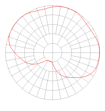 | ||||||||||||||||||||||||
| Azimuth | Ratio | Azimuth | Ratio | Azimuth | Ratio | Azimuth | Ratio | ||||||||||||||||||
| 0 | 0.963 | 10 | 0.985 | 20 | 0.992 | 30 | 0.987 | ||||||||||||||||||
| 40 | 0.966 | 50 | 0.938 | 60 | 0.935 | 70 | 0.963 | ||||||||||||||||||
| 80 | 0.989 | 90 | 0.994 | 100 | 0.987 | 110 | 0.974 | ||||||||||||||||||
| 120 | 0.921 | 130 | 0.811 | 140 | 0.695 | 150 | 0.604 | ||||||||||||||||||
| 160 | 0.504 | 170 | 0.363 | 180 | 0.235 | 190 | 0.190 | ||||||||||||||||||
| 200 | 0.195 | 210 | 0.193 | 220 | 0.228 | 230 | 0.348 | ||||||||||||||||||
| 240 | 0.495 | 250 | 0.602 | 260 | 0.691 | 270 | 0.803 | ||||||||||||||||||
| 280 | 0.917 | 290 | 0.979 | 300 | 0.993 | 310 | 0.999 | ||||||||||||||||||
| 320 | 0.996 | 330 | 0.972 | 340 | 0.941 | 350 | 0.937 | ||||||||||||||||||
Structure Registration Number 1222106 [ASR Heights Differ from KVEO-TV Application] Structure Type: GTOWER Registered To: Pinnacle Towers LLC Structure Address: 31578 County Road 629 La Feria, TX County Name: Cameron County ASR Issued: 12/01/2021 Date Built: 08/20/2001 Site Elevation: 17.1 m (56 ft.) Structure Height: 427.6 m (1403 ft.) Height Overall: 454.5 m (1491 ft.) Overall Height AMSL: 471.6 m (1547 ft.) FAA Determination: 04/01/2010 FAA Study #: 2009-ASW-5731-OE FAA Circular #: 70/7460-1K Paint & Light FAA Chapters: 4, 9, 12 PRIOR STUDY 2009-ASW-4241-OE 26-06-02.3 N 97-50-21.5 W (NAD 83) 26-06-01.0 N 97-50-20.5 W (Converted to NAD 27) |
545 E. John Carpenter Freeway Suite 700 Irving, TX 75062 Phone: 972-373-8800 Corporation | Date: 06/30/2005 Application Certifier COMCORP OF TEXAS LICENSE CORP. P.o. Box 53708 Lafayette, LA 70505-3708 Applicant MATTHEW A. SANDERFORD, JR., P.E. P.o. Box 485 Alvarado, TX 76009-0485 CONSULTING ENGINEER VINCENT J. CURTIS, JR. Fletcher, Heald & Hildreth, P.l.c. 1300 N. 17th Street Eleventh Floor Arlington, VA 22209 | |||||||||||||||||||||||
| |||||||||||||||||||||||||