
FCCInfo.com
A Service of Cavell, Mertz & Associates, Inc.
(855) FCC-INFO
|
|
|
Post-repack Channel 20 Virtual Channel 33 |  |
|
|||||||||||||||||||||||||||||||||||||||||||||
|
|
Repacking Information: Pre-Repack Channel: 25 Post-Repack Channel: 20 Post-Repack ERP: 111 kW Phase: 5 Completion Deadline: 9/11/2019 Upstream/Downstream Dependencies Other Linked Stations Find nearby TV Facilities Status: License (Licensed And Reduced Power) Application Accepted: 04/01/2003 License Expires: 12/01/2020 File Number: BLEDT-20030401BAI Prefix Type: This is a license for a noncommercial educational digital TV station FCC Website Links: LMS Facility Details This Application Other WUNF-TV Applications Including Superseded Applications Mailing Address Correspondence for WUNF-TV Correspondence related to application BLEDT-20030401BAI Service Contour - Open Street Map or USGS Map (41 dBu) Service Contour - KML / Google Earth (41 dBu) Public Inspection Files History Cards for WUNF-TV Rabbit Ears Info Search for WUNF-TV Site Location: 35-25-32.0 N 82-45-24.0 W (NAD 83) Site Location: 35-25-31.6 N 82-45-24.5 W (Converted to NAD 27) ERP: 125 kW Polarization: Horizontally polarized HAAT: 816 m (2677 ft.) Electrical Beam Tilt: 0.75 degrees R/C AGL: 59 m (194 ft.) R/C AMSL: 1802 m (5912 ft.) Site Elevation: 1743 m. (5719 ft.) Height Overall*: 103 m (338 ft.) (* As Filed In This Application, may differ from ASR Data, Below.) Directional Antenna - Antenna Make/Model: DIELECTRIC TFU-10DSC-RC170 Antenna ID: 87421 Polarization: Horizontally polarized
| ||||||||||||||||||||||||||||||||||||||||||||||||
| Antenna Data for Antenna Id: 87421 WUNF-TV DT File: BLEDT-20030401BAI DIELECTRIC - TFU-10DSC-RC170 Service: DT Standard Pattern: Y | 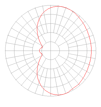 | ||||||||||||||||||||||||||||||||||||||||||||||||
| Azimuth | Ratio | Azimuth | Ratio | Azimuth | Ratio | Azimuth | Ratio | ||||||||||||||||||||||||||||||||||||||||||
| 0 | 0.940 | 10 | 0.987 | 20 | 1.000 | 30 | 0.988 | ||||||||||||||||||||||||||||||||||||||||||
| 40 | 0.963 | 45 | 0.949 | 50 | 0.936 | 60 | 0.917 | ||||||||||||||||||||||||||||||||||||||||||
| 70 | 0.905 | 80 | 0.900 | 90 | 0.899 | 100 | 0.900 | ||||||||||||||||||||||||||||||||||||||||||
| 110 | 0.905 | 120 | 0.917 | 130 | 0.936 | 135 | 0.949 | ||||||||||||||||||||||||||||||||||||||||||
| 140 | 0.963 | 150 | 0.968 | 160 | 1.000 | 170 | 0.987 | ||||||||||||||||||||||||||||||||||||||||||
| 180 | 0.940 | 190 | 0.854 | 200 | 0.733 | 210 | 0.588 | ||||||||||||||||||||||||||||||||||||||||||
| 220 | 0.437 | 225 | 0.365 | 230 | 0.302 | 240 | 0.218 | ||||||||||||||||||||||||||||||||||||||||||
| 250 | 0.207 | 260 | 0.232 | 270 | 0.245 | 280 | 0.232 | ||||||||||||||||||||||||||||||||||||||||||
| 290 | 0.201 | 300 | 0.218 | 310 | 0.302 | 315 | 0.365 | ||||||||||||||||||||||||||||||||||||||||||
| 320 | 0.437 | 330 | 0.588 | 340 | 0.730 | 350 | 0.854 | ||||||||||||||||||||||||||||||||||||||||||
Structure Registration Number 1035173 Structure Type: TOWER Registered To: Sinclair Communications, LLC Structure Address: Top Of Mount Pisgah, Near Asheville Canton, NC County Name: Haywood County ASR Issued: 01/11/2017 Date Built: 01/01/1954 Site Elevation: 1742.8 m (5718 ft.) Structure Height: 102.3 m (336 ft.) Height Overall: 103.2 m (339 ft.) Overall Height AMSL: 1846 m (6056 ft.) FAA Determination: 10/16/2008 FAA Study #: 2008-ASO-5728-OE FAA Circular #: 70/7460-1K Paint & Light FAA Chapters: 4, 8, 12 PRIOR STUDY 1977-ASO-1226-OE 35-25-32.0 N 82-45-24.0 W (NAD 83) 35-25-31.6 N 82-45-24.5 W (Converted to NAD 27) |
10 Unc-tv Drive Research Triangle Park, NC 27709 Phone: 919-549-7000 Government Entity | Date: 04/01/2003 Application Certifier UNIVERSITY OF NORTH CAROLINA P.o. Box 14900 Research Triangle Pa, NC 27709 Applicant WAYNE ESTABROOKS P.o. Box 14900 Research Triangle Pk, NC 27709 CHIEF ENGINEER - TRANSMISSION MARCUS W. TRATHEN Brooks, Pierce Et. Al. P.o. Box 1800 Raleigh, NC 27602 | |||||||||||||||||||||||||||||||||||||||||||||||
| |||||||||||||||||||||||||||||||||||||||||||||||||