
FCCInfo.com
A Service of Cavell, Mertz & Associates, Inc.
(855) FCC-INFO
|
|
KPTF-DT from 06/29/2000 KPTF-DT from 06/01/1998 |
Virtual Channel 18 |
|
||||||||||||||||
|
|
Repacking Information: No changes Status: License Application Accepted: 06/12/2009 License Expires: 08/01/2022 File Number: BLCDT-20090612AEB Prefix Type: This is a License for a commercial digital TV station FCC Website Links: LMS Facility Details This Application Other KPTF-DT Applications Including Superseded Applications Mailing Address Correspondence for KPTF-DT Correspondence related to application BLCDT-20090612AEB Service Contour - Open Street Map or USGS Map (41 dBu) Service Contour - KML / Google Earth (41 dBu) Public Inspection Files Rabbit Ears Info Search for KPTF-DT Site Location: 34-26-21.3 N 103-12-23.8 W (NAD 83) Site Location: 34-26-21.0 N 103-12-22.0 W (Converted to NAD 27) ERP: 50 kW Polarization: Horizontally polarized HAAT: 112 m (367 ft.) R/C AGL: 109.7 m (360 ft.) R/C AMSL: 1423.7 m (4671 ft.) Site Elevation: 1314 m. (4311 ft.) Height Overall*: 140 m (459 ft.) (* As Filed In This Application, may differ from ASR Data, Below.) Directional Antenna - Antenna Make/Model: Propagation System Inc PSILPD28MBFA/18 Antenna ID: 85180 Polarization: Horizontally polarized | ||||||||||||||||||
| Antenna Data for Antenna Id: 85180 KPTF-DT DT File: BLCDT-20090612AEB Propagation System Inc - PSILPD28MBFA/18 Service: DT Standard Pattern: Y | 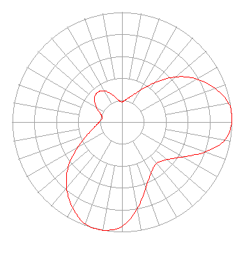 | ||||||||||||||||||
| Azimuth | Ratio | Azimuth | Ratio | Azimuth | Ratio | Azimuth | Ratio | ||||||||||||
| 0 | 0.184 | 10 | 0.208 | 20 | 0.252 | 30 | 0.332 | ||||||||||||
| 40 | 0.467 | 50 | 0.640 | 60 | 0.785 | 70 | 0.900 | ||||||||||||
| 80 | 0.985 | 85 | 1.000 | 90 | 1.000 | 100 | 0.950 | ||||||||||||
| 110 | 0.800 | 120 | 0.635 | 130 | 0.533 | 140 | 0.491 | ||||||||||||
| 150 | 0.533 | 160 | 0.635 | 170 | 0.800 | 180 | 0.950 | ||||||||||||
| 190 | 1.000 | 200 | 0.985 | 210 | 0.900 | 220 | 0.785 | ||||||||||||
| 230 | 0.640 | 240 | 0.467 | 250 | 0.332 | 260 | 0.252 | ||||||||||||
| 270 | 0.208 | 280 | 0.184 | 290 | 0.204 | 300 | 0.268 | ||||||||||||
| 310 | 0.329 | 320 | 0.350 | 330 | 0.329 | 340 | 0.268 | ||||||||||||
| 350 | 0.204 | ||||||||||||||||||
Structure Registration Number 1218040 Structure Type: GTOWER Registered To: American Towers LLC Structure Address: 1074 State Route 245 (#209129) Clovis, NM County Name: Curry County ASR Issued: 12/16/2021 Date Built: 08/29/2014 Site Elevation: 1313.7 m (4310 ft.) Structure Height: 134.1 m (440 ft.) Height Overall: 140.2 m (460 ft.) Overall Height AMSL: 1453.9 m (4770 ft.) FAA Determination: 12/07/2021 FAA Study #: 2021-ASW-11359-OE FAA Circular #: 70/7460-1M Paint & Light FAA Chapters: 4, 8, 15 PRIOR STUDY 2014-ASW-3513-OE 34-26-24.2 N 103-12-31.8 W (NAD 83) 34-26-23.9 N 103-12-30.0 W (Converted to NAD 27) |
12706 W Hwy 80 E Odessa, TX 79765 Phone: 432-563-5200 Corporation | Date: 06/12/2009 Application Certifier PRIME TIME CHRISTIAN BROADCASTING, INC 12706 West Highway 80 East Odessa, TX 79765 Applicant DELBERT DICK Po Box 61000 Midland, TX 79711 ASSISTANT CHIEF ENGINEER JEROLD L. JACOBS, ESQ. Cohn And Marks Llp 1920 N Street, N.w. Suite 300 Washington, DC 20036-1622 | |||||||||||||||||